TopoQuest Logo
Do you find TopoQuest useful?
Help keep TopoQuest running and adding new maps/features by donating!
Bitcoin:  19c7KJd3qBynnjoSw5npx9KScwjBe4ifkT
Litecoin:  LXs6TkuXGGXo1vDsWCkWVdjQX94eUKd6ui
Home View Maps Find Maps Find Places Resources & Links


North Twin Lake, Minnesota Topographic Map

USGS Map Title: North Twin Lake, MN
USGS Map MRC: 47095C6
DRG (GeoTIFF) Download: o47095c6.tif


Neighboring USGS Topographic Map Quads:


  Mahnomen NE, MN  
47095D7
 

  Ebro NW, MN  
47095D6
 

  Ebro, MN  
47095D5
 

  Beaulieu, MN  
47095C7
 

  North Twin Lake, MN  
47095C6
 

  Roy Lake, MN  
47095C5
 

  Ogema NE, MN  
47095B7
 

  Snider Lake, MN  
47095B6
 

  Tulaby Lake, MN  
47095B5


Map MRC Location:

N48°
W96°
N48°
W95°
H8 H7 H6 H5 H4 H3 H2 H1
G8 G7 G6 G5 G4 G3 G2 G1
F8 F7 F6 F5 F4 F3 F2 F1
E8 E7 E6 E5 E4 E3 E2 E1
D8 D7 D6 D5 D4 D3 D2 D1
C8 C7 C6 C5 C4 C3 C2 C1
B8 B7 B6 B5 B4 B3 B2 B1
A8 A7 A6 A5 A4 A3 A2 A1
N47°
W96°
N47°
W95°

North Twin Lake, MN USGS 1:24K Topographic Map Preview:
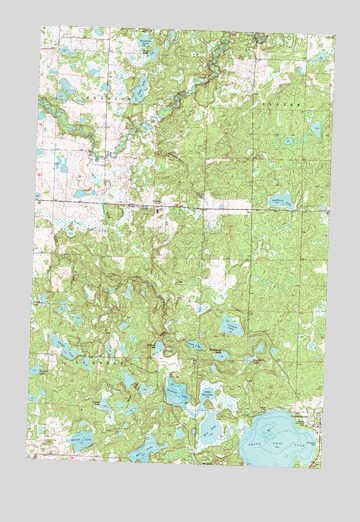
North Twin Lake, MN USGS Topographic Map
Click on map above to begin viewing in our Map Viewer.

This topographic map contains these locations and features:
Feature Name Type Latitude Longitude GNIS ID View Map
Badboy CreekStreamN47.2594°W95.6284°639554View Map
Barney LakesLakeN47.2738°W95.7081°639640View Map
Buresh LakeLakeN47.2557°W95.7267°640652View Map
Crooked LakeLakeN47.2659°W95.7173°642464View Map
Daigle LakeLakeN47.2822°W95.7353°642596View Map
Fairbanks LakeLakeN47.2806°W95.6575°643496View Map
Gardner LakeLakeN47.2750°W95.7498°644035View Map
Goodwin LakeLakeN47.3266°W95.6462°644231View Map
Grass LakeLakeN47.2844°W95.6806°644381View Map
Hart LakeLakeN47.2534°W95.7000°644703View Map
Indian CemeteryCemeteryN47.2666°W95.6495°645401View Map
Island LakeLakeN47.3667°W95.7018°645490View Map
Little Rice LakeLakeN47.2705°W95.6750°646904View Map
Lizzard LakeLakeN47.2899°W95.6652°646975View Map
Long LakeLakeN47.3571°W95.7073°647102View Map
NaytahwaushPopulated PlaceN47.2627°W95.6261°648434View Map
Naytahwaush Census Designated PlaceCensusN47.2703°W95.6335°2393144View Map
Naytahwaush Post OfficePost OfficeN47.2628°W95.6258°2082701View Map
Naytahwaush SchoolSchoolN47.2622°W95.6269°2082700View Map
North Twin LakeLakeN47.2563°W95.6447°648708View Map
Peabody LakeLakeN47.2837°W95.6950°649197View Map
Rice LakeLakeN47.2600°W95.6726°650018View Map
Saint Anne Catholic ChurchChurchN47.2628°W95.6258°2082698View Map
Samuel Memorial CemeteryCemeteryN47.2633°W95.6325°651128View Map
Samuel Memorial Lutheran ChurchChurchN47.2628°W95.6258°2082699View Map
Sargent LakeLakeN47.2758°W95.6909°651217View Map
Schimmelhorn CreekStreamN47.3461°W95.7025°651286View Map
Swanson LakeLakeN47.3713°W95.7061°652915View Map
The Ranch Census Designated PlaceCensusN47.3198°W95.6952°2583781View Map
Township of BeaulieuCivilN47.3678°W95.7417°663535View Map
Township of La GardeCivilN47.2806°W95.7422°664656View Map
Twin CreekStreamN47.3386°W95.7270°653410View Map
Twin Lakes Volunteer Fire DepartmentBuildingN47.2602°W95.6270°2666363View Map
Woodchuck LakeLakeN47.2815°W95.6689°654349View Map

Note: Coordinates in the location and feature list above are referenced to NAD83 datum.


Copyright (C) 2008-2025 Ryan Niemi / Sunset Dynamics ... All Rights Reserved