TopoQuest Logo
Do you find TopoQuest useful?
Help keep TopoQuest running and adding new maps/features by donating!
Bitcoin:  19c7KJd3qBynnjoSw5npx9KScwjBe4ifkT
Litecoin:  LXs6TkuXGGXo1vDsWCkWVdjQX94eUKd6ui
Home View Maps Find Maps Find Places Resources & Links


Norton, Kansas Topographic Map

USGS Map Title: Norton, KS
USGS Map MRC: 39099G8
DRG (GeoTIFF) Download: o39099g8.tif


Neighboring USGS Topographic Map Quads:


  Devizes, KS  
39100H1
 

  Norton NW, KS  
39099H8
 

  Norton NE, KS  
39099H7
 

  Reager, KS  
39100G1
 

  Norton, KS  
39099G8
 

  Calvert, KS  
39099G7
 

  Clayton NE, KS  
39100F1
 

  Edmond NW, KS  
39099F8
 

  Edmond, KS  
39099F7


Map MRC Location:

N40°
W100°
N40°
W99°
H8 H7 H6 H5 H4 H3 H2 H1
G8 G7 G6 G5 G4 G3 G2 G1
F8 F7 F6 F5 F4 F3 F2 F1
E8 E7 E6 E5 E4 E3 E2 E1
D8 D7 D6 D5 D4 D3 D2 D1
C8 C7 C6 C5 C4 C3 C2 C1
B8 B7 B6 B5 B4 B3 B2 B1
A8 A7 A6 A5 A4 A3 A2 A1
N39°
W100°
N39°
W99°

Norton, KS USGS 1:24K Topographic Map Preview:
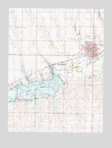
Norton, KS USGS Topographic Map
Click on map above to begin viewing in our Map Viewer.

This topographic map contains these locations and features:
Feature Name Type Latitude Longitude GNIS ID View Map
City of NortonCivilN39.8364°W99.8916°485631View Map
Community Full Gospel ChurchChurchN39.8303°W99.8925°2690964View Map
Cope CemeteryCemeteryN39.7838°W99.9501°471902View Map
Eisenhower Elementary SchoolSchoolN39.8409°W99.8945°480195View Map
Elmwood Park SpeedwayLocaleN39.8249°W99.8842°2692839View Map
First Baptist ChurchChurchN39.8285°W99.8850°2690965View Map
First Church of GodChurchN39.8400°W99.8980°2689711View Map
First United Methodist ChurchChurchN39.8365°W99.8988°2690440View Map
Horseshoe HillSummitN39.8056°W99.8893°471900View Map
Immanuel Lutheran ChurchChurchN39.8378°W99.8919°2690966View Map
Kansas Department of Transportation District Three OfficeBuildingN39.8263°W99.8918°2625201View Map
Kansas National Guard Armory NortonMilitaryN39.8428°W99.8895°2625182View Map
Keith Sebelius LakeReservoirN39.8042°W99.9321°471029View Map
KQNK - FM (Norton)BuildingN39.7975°W99.8917°2625300View Map
Living Hope FellowshipChurchN39.8123°W99.8891°2690967View Map
NortonPopulated PlaceN39.8339°W99.8915°471901View Map
Norton Christian ChurchChurchN39.8307°W99.8886°2690968View Map
Norton City HallBuildingN39.8285°W99.8869°2693228View Map
Norton City Volunteer Fire DepartmentBuildingN39.8285°W99.8868°2111671View Map
Norton Community High SchoolSchoolN39.8362°W99.8956°480192View Map
Norton CountyCivilN39.7844°W99.9035°485032View Map
Norton County CourthouseBuildingN39.8287°W99.8878°2625113View Map
Norton County Emergency Medical ServicesBuildingN39.8377°W99.8872°2696574View Map
Norton County Equine FacilityLocaleN39.8239°W99.8863°2692718View Map
Norton County Health DepartmentBuildingN39.8372°W99.8872°2695043View Map
Norton County Historical Society and MuseumBuildingN39.8304°W99.8886°2694909View Map
Norton County HospitalHospitalN39.8380°W99.8881°2499085View Map
Norton County JailBuildingN39.8286°W99.8876°2504350View Map
Norton County Rural Fire District 2BuildingN39.8399°W99.8892°2111672View Map
Norton County Sheriff's OfficeBuildingN39.8286°W99.8876°2503945View Map
Norton DamDamN39.8042°W99.9321°480194View Map
Norton Junior High SchoolSchoolN39.8367°W99.8948°480193View Map
Norton Municipal AirportAirportN39.8466°W99.8918°481337View Map
Norton Municipal Power PlantLocaleN39.8210°W99.8935°2692443View Map
Norton Police DepartmentBuildingN39.8285°W99.8867°2504067View Map
Norton Post OfficePost OfficeN39.8280°W99.8869°2693887View Map
Norton Seventh Day Adventist ChurchChurchN39.8286°W99.8936°2689293View Map
Norton Water Treatment PlantLocaleN39.8208°W99.8944°2693590View Map
Norton Wildlife AreaParkN39.7828°W99.9793°471028View Map
Prairie Dog Golf ClubLocaleN39.8161°W99.8767°2694505View Map
Prairie Dog State ParkParkN39.8069°W99.9515°471899View Map
Prairie Dog State Park Branded Cedar CampgroundLocaleN39.8004°W99.9705°2624998View Map
Prairie Dog State Park Meadowlark CampgroundLocaleN39.8008°W99.9609°2624999View Map
Prairie Dog State Park OfficeBuildingN39.8121°W99.9630°2625206View Map
Prairie Dog State Park Prairie Dog CampgroundLocaleN39.8050°W99.9436°2625000View Map
Prairie Dog State Park Shady Rest CampgroundLocaleN39.8029°W99.9449°2625001View Map
Prairie Dog State Park West Shoreline Loop CampingLocaleN39.7986°W99.9616°2625002View Map
Redeemer Evangelical Lutheran ChurchChurchN39.8377°W99.9000°2690969View Map
Robinson CreekStreamN39.8250°W99.8962°471728View Map
Saint Francis of Assisi Catholic ChurchChurchN39.8283°W99.8863°2690970View Map
Trinity Episcopal ChurchChurchN39.8325°W99.8886°2690971View Map
Valley Hope Association Treatment CenterBuildingN39.8387°W99.8971°2499060View Map

Note: Coordinates in the location and feature list above are referenced to NAD83 datum.


Copyright (C) 2008-2025 Ryan Niemi / Sunset Dynamics ... All Rights Reserved