TopoQuest Logo
Do you find TopoQuest useful?
Help keep TopoQuest running and adding new maps/features by donating!
Bitcoin:  19c7KJd3qBynnjoSw5npx9KScwjBe4ifkT
Litecoin:  LXs6TkuXGGXo1vDsWCkWVdjQX94eUKd6ui
Home View Maps Find Maps Find Places Resources & Links


Noxon, Montana Topographic Map

USGS Map Title: Noxon, MT
USGS Map MRC: 47115H7
DRG (GeoTIFF) Download: o47115h7.tif


Neighboring USGS Topographic Map Quads:


  Heron, MT  
48115A8
 

  Smeads Bench, MT  
48115A7
 

  Elephant Peak, MT  
48115A6
 

  Gem Peak, MT  
47115H8
 

  Noxon, MT  
47115H7
 

  Noxon Rapids Dam, MT  
47115H6
 

  Taylor Peak, ID  
47115G8
 

  Bloom Peak, MT  
47115G7
 

  Larchwood, MT  
47115G6


Map MRC Location:

N48°
W116°
N48°
W115°
H8 H7 H6 H5 H4 H3 H2 H1
G8 G7 G6 G5 G4 G3 G2 G1
F8 F7 F6 F5 F4 F3 F2 F1
E8 E7 E6 E5 E4 E3 E2 E1
D8 D7 D6 D5 D4 D3 D2 D1
C8 C7 C6 C5 C4 C3 C2 C1
B8 B7 B6 B5 B4 B3 B2 B1
A8 A7 A6 A5 A4 A3 A2 A1
N47°
W116°
N47°
W115°

Noxon, MT USGS 1:24K Topographic Map Preview:
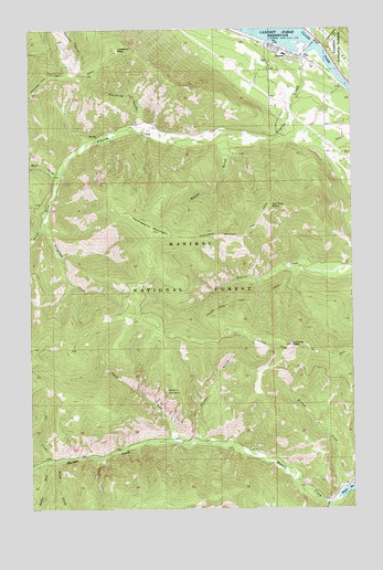
Noxon, MT USGS Topographic Map
Click on map above to begin viewing in our Map Viewer.

This topographic map contains these locations and features:
Feature Name Type Latitude Longitude GNIS ID View Map
26N32W19CDDB01 WellWellN47.9905°W115.7741°825391View Map
26N32W30BABA01 WellWellN47.9891°W115.7752°825377View Map
26N33W25ADDA01 WellWellN47.9833°W115.7830°825356View Map
Baxter GulchValleyN47.9722°W115.7949°779453View Map
Clinton GulchValleyN47.8922°W115.8088°781404View Map
Devil GapValleyN47.8930°W115.8199°782321View Map
Fir CreekStreamN47.8874°W115.8674°783400View Map
Fourmile GulchValleyN47.9741°W115.8307°783650View Map
Government CreekStreamN47.9949°W115.7616°784138View Map
Hole-in-the-WallBasinN47.9060°W115.8243°784934View Map
Huckleberry MountainSummitN47.9472°W115.8263°785134View Map
Huckleberry Mountain TrailTrailN47.9463°W115.7921°785136View Map
Kismet CreekStreamN47.8805°W115.7543°785776View Map
Loveland PeakSummitN47.9947°W115.8418°786651View Map
Marten CreekStreamN47.8780°W115.7571°786872View Map
NoxonPopulated PlaceN47.9960°W115.7816°788328View Map
Noxon BridgeBridgeN47.9958°W115.7663°1780921View Map
Noxon CemeteryCemeteryN47.9905°W115.7834°1780932View Map
Noxon Census Designated PlaceCensusN47.9850°W115.7709°2408959View Map
Noxon ClinicHospitalN47.9960°W115.7816°1780891View Map
Noxon Community AmbulanceBuildingN47.9945°W115.7766°2637883View Map
Noxon Community MuseumBuildingN47.9960°W115.7816°1780897View Map
Noxon Methodist ChurchChurchN47.9960°W115.7816°1780874View Map
Noxon Post OfficePost OfficeN47.9928°W115.7738°1781008View Map
Noxon Public SchoolsSchoolN47.9930°W115.7768°1780851View Map
Noxon Rural Fire DistrictBuildingN47.9948°W115.7773°1780826View Map
Old Trail PointCliffN47.9538°W115.7824°788427View Map
Pilgrim CreekStreamN47.9947°W115.7652°788860View Map
Rabbit RunStreamN47.8871°W115.8705°789315View Map
South Fork Marten CreekStreamN47.8766°W115.7604°791011View Map
South Fork Pilgrim CreekStreamN47.9635°W115.8630°791026View Map
Steep CreekStreamN47.8874°W115.8657°791484View Map
Stevens Creek TrailTrailN47.9277°W115.7979°791499View Map
Stevens PeakSummitN47.9177°W115.7749°791502View Map
Stevens Ridge TrailTrailN47.9227°W115.8505°791503View Map
Telegraph CreekStreamN47.9499°W115.8699°791942View Map
Weares Spur (historical)LocaleN47.9994°W115.7613°1781029View Map
West Fork Pilgrim CreekStreamN47.9635°W115.8630°793057View Map
White Star MineMineN47.9655°W115.8671°805128View Map

Note: Coordinates in the location and feature list above are referenced to NAD83 datum.


Copyright (C) 2008-2025 Ryan Niemi / Sunset Dynamics ... All Rights Reserved