TopoQuest Logo
Do you find TopoQuest useful?
Help keep TopoQuest running and adding new maps/features by donating!
Bitcoin:  19c7KJd3qBynnjoSw5npx9KScwjBe4ifkT
Litecoin:  LXs6TkuXGGXo1vDsWCkWVdjQX94eUKd6ui
Home View Maps Find Maps Find Places Resources & Links


Nutall Rise, Florida Topographic Map

USGS Map Title: Nutall Rise, FL
USGS Map MRC: 30083B8
DRG (GeoTIFF) Download: o30083b8.tif


Neighboring USGS Topographic Map Quads:


  Cody, FL  
30084C1
 

  Wacissa, FL  
30083C8
 

  Lamont SE, FL  
30083C7


  Nutall Rise, FL  
30083B8
 

  Johnson Hammock, FL  
30083B7
 

  Cobb Rocks, FL  
30084A1
 

  Snipe Island, FL  
30083A8
 

  Manlin Hammock, FL  
30083A7


Map MRC Location:

N31°
W84°
N31°
W83°
H8 H7 H6 H5 H4 H3 H2 H1
G8 G7 G6 G5 G4 G3 G2 G1
F8 F7 F6 F5 F4 F3 F2 F1
E8 E7 E6 E5 E4 E3 E2 E1
D8 D7 D6 D5 D4 D3 D2 D1
C8 C7 C6 C5 C4 C3 C2 C1
B8 B7 B6 B5 B4 B3 B2 B1
A8 A7 A6 A5 A4 A3 A2 A1
N30°
W84°
N30°
W83°

Nutall Rise, FL USGS 1:24K Topographic Map Preview:
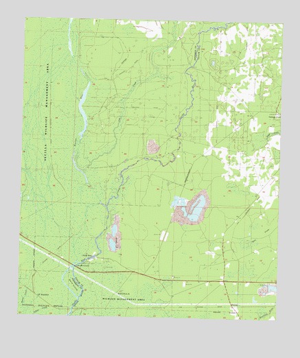
Nutall Rise, FL USGS Topographic Map
Click on map above to begin viewing in our Map Viewer.

This topographic map contains these locations and features:
Feature Name Type Latitude Longitude GNIS ID View Map
Aucilla Wildlife Management AreaParkN30.1880°W83.9782°304924View Map
BuckhornPopulated PlaceN30.1358°W83.9149°300834View Map
Bushy HammockIslandN30.1647°W83.8868°300835View Map
Cabbage Grove Lookout TowerTowerN30.2122°W83.8765°300837View Map
Cow CreekStreamN30.1852°W83.9693°280926View Map
Goose PastureFlatN30.2038°W83.9616°300049View Map
Hells Half AcreIslandN30.2191°W83.9821°300050View Map
Ilcombe (historical)Populated PlaceN30.1335°W83.8999°294534View Map
Little Ward IslandIslandN30.1469°W83.9721°285848View Map
Nutall RisePopulated PlaceN30.1505°W83.9641°287917View Map
Page CreekStreamN30.2010°W83.8818°288371View Map
Powell HammockIslandN30.1791°W83.9077°300836View Map
San Juan de Guacara (historical)Populated PlaceN30.1835°W83.9332°294541View Map
ScanlonPopulated PlaceN30.1305°W83.8960°295603View Map
Slave CanalCanalN30.1653°W83.9686°2081604View Map
Wacissa RiverStreamN30.1716°W83.9582°292811View Map
Ward IslandIslandN30.1380°W83.9738°292873View Map

Note: Coordinates in the location and feature list above are referenced to NAD83 datum.


Copyright (C) 2008-2024 Ryan Niemi / Sunset Dynamics ... All Rights Reserved