TopoQuest Logo
Do you find TopoQuest useful?
Help keep TopoQuest running and adding new maps/features by donating!
Bitcoin:  19c7KJd3qBynnjoSw5npx9KScwjBe4ifkT
Litecoin:  LXs6TkuXGGXo1vDsWCkWVdjQX94eUKd6ui
Home View Maps Find Maps Find Places Resources & Links


Belvidere, New Jersey Topographic Map

USGS Map Title: Belvidere, NJ
USGS Map MRC: 40075G1
DRG (GeoTIFF) Download: o40075g1.tif


Neighboring USGS Topographic Map Quads:


  Stroudsburg, PA  
40075H2
 

  Portland, PA  
40075H1
 

  Blairstown, NJ  
40074H8
 

  Bangor, PA  
40075G2
 

  Belvidere, NJ  
40075G1
 

  Washington, NJ  
40074G8
 

  Easton, PA  
40075F2
 

  Bloomsbury, NJ  
40075F1
 

  High Bridge, NJ  
40074F8


Map MRC Location:

N41°
W76°
N41°
W75°
H8 H7 H6 H5 H4 H3 H2 H1
G8 G7 G6 G5 G4 G3 G2 G1
F8 F7 F6 F5 F4 F3 F2 F1
E8 E7 E6 E5 E4 E3 E2 E1
D8 D7 D6 D5 D4 D3 D2 D1
C8 C7 C6 C5 C4 C3 C2 C1
B8 B7 B6 B5 B4 B3 B2 B1
A8 A7 A6 A5 A4 A3 A2 A1
N40°
W76°
N40°
W75°

Belvidere, NJ USGS 1:24K Topographic Map Preview:
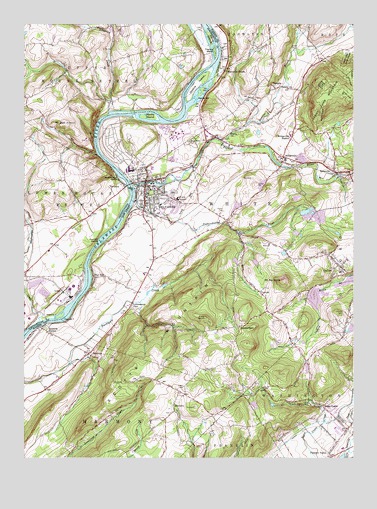
Belvidere, NJ USGS Topographic Map
Click on map above to begin viewing in our Map Viewer.

This topographic map contains these locations and features:
Feature Name Type Latitude Longitude GNIS ID View Map
Allegheny CreekStreamN40.8493°W75.0924°1168167View Map
Angens PondReservoirN40.7654°W75.0372°883814View Map
Angens Pond DamDamN40.7659°W75.0371°883813View Map
Attins IslandsIslandN40.8709°W75.0538°1168493View Map
Beaver BrookStreamN40.8415°W75.0505°874612View Map
BelviderePopulated PlaceN40.8298°W75.0777°874662View Map
Belvidere Corner SchoolSchoolN40.8626°W75.0760°1196217View Map
Belvidere Ferry (historical)LocaleN40.8268°W75.0835°1210919View Map
Belvidere Police DepartmentBuildingN40.8329°W75.0671°2730887View Map
Belvidere Volunteer Ambulance CorpsBuildingN40.8316°W75.0801°2659765View Map
Brass CastlePopulated PlaceN40.7648°W75.0110°874910View Map
Brass Castle Census Designated PlaceCensusN40.7621°W75.0141°2389234View Map
Brass Castle Elementary SchoolSchoolN40.7588°W75.0060°2372508View Map
BridgevillePopulated PlaceN40.8368°W75.0260°874932View Map
Bridgeville Census Designated PlaceCensusN40.8371°W75.0244°2583973View Map
Bridgeville StationLocaleN40.8420°W75.0230°874933View Map
Brookfield Census Designated PlaceCensusN40.8184°W75.0613°2583976View Map
ButtzvillePopulated PlaceN40.8323°W75.0063°875065View Map
Buttzville Census Designated PlaceCensusN40.8311°W75.0051°2583978View Map
Capush IslandIslandN40.7901°W75.1091°875196View Map
CornishPopulated PlaceN40.7976°W75.0346°875655View Map
Dildine IslandIslandN40.8579°W75.0585°875920View Map
DSM Emergency Medical ServicesBuildingN40.8411°W75.0653°2660195View Map
DSM Industrial Products Fire and Rescue BrigadeBuildingN40.8424°W75.0650°2614398View Map
Foul RiftPopulated PlaceN40.8023°W75.0977°876430View Map
Foul RiftChannelN40.8101°W75.0980°1196222View Map
Foul Rift FallsFallsN40.8112°W75.0949°883779View Map
Foul Rift FerryLocaleN40.8101°W75.0980°1210920View Map
Foul Rift IslandsIslandN40.8141°W75.0943°876431View Map
Good Will Fire Company Station 1BuildingN40.8327°W75.0687°2613784View Map
Gravel Hill School (historical)SchoolN40.8251°W75.1043°1196221View Map
Hartzells FerryPopulated PlaceN40.8526°W75.0910°1212005View Map
Hartzells Ferry (historical)LocaleN40.8495°W75.0882°1196218View Map
HazenPopulated PlaceN40.8143°W75.0430°877022View Map
Hazen CemeteryCemeteryN40.8206°W75.0507°877023View Map
Hillside CemeteryCemeteryN40.7913°W75.0025°877131View Map
Johnson Farms Airport (historical)AirportN40.7501°W75.0657°884664View Map
Lommasons GlenPopulated PlaceN40.7943°W75.0830°877899View Map
Mackeys OrchardLocaleN40.8056°W75.0900°2516007View Map
Macks BarBarN40.8534°W75.0588°878009View Map
Macks IslandIslandN40.8484°W75.0763°878010View Map
Manunka ChunkPopulated PlaceN40.8615°W75.0482°878087View Map
Martins Creek Airport (historical)AirportN40.8084°W75.1135°2026725View Map
Masons IslandIslandN40.7907°W75.1107°1180532View Map
Matarazzo FarmsLocaleN40.8647°W75.0167°2516008View Map
Matthews AirportAirportN40.7935°W75.0721°884663View Map
McElhaneys IslandIslandN40.8301°W75.0871°1180704View Map
Mill CreekStreamN40.8376°W75.0968°1202327View Map
MontanaPopulated PlaceN40.7651°W75.0674°878446View Map
Mount JackSummitN40.8465°W75.1085°1177900View Map
Mount Jack County ParkParkN40.8490°W75.0960°1196219View Map
Mount No MoreSummitN40.8007°W75.0263°878810View Map
Ott HillSummitN40.8495°W75.1230°1196220View Map
Oughoughton CreekStreamN40.7890°W75.1191°1183095View Map
Oxford QuarryMineN40.8200°W75.0178°2559292View Map
Pequest RiverStreamN40.8286°W75.0832°879231View Map
Pleasant ValleyPopulated PlaceN40.7515°W75.0082°879366View Map
Pophandusing BrookStreamN40.8241°W75.0829°879429View Map
RivertonPopulated PlaceN40.8279°W75.0860°1204518View Map
RoxburgPopulated PlaceN40.7801°W75.0996°879847View Map
Roxburg StationLocaleN40.7873°W75.1152°879846View Map
SareptaPopulated PlaceN40.8568°W75.0296°880268View Map
Schoch SchoolSchoolN40.8740°W75.0924°1196216View Map
Stoneyfield OrchardsLocaleN40.8311°W75.0583°2516014View Map
SummerfieldPopulated PlaceN40.7876°W75.0430°880991View Map
Thomas IslandIslandN40.8676°W75.0521°1189482View Map
Town of BelvidereCivilN40.8294°W75.0728°885156View Map
Township of HarmonyCivilN40.7527°W75.1246°882248View Map
Township of WhiteCivilN40.8218°W75.0414°882246View Map
Warren County Correctional CenterBuildingN40.8025°W75.0809°2733222View Map
Warren County Sheriff's Office - Police OfficeBuildingN40.8276°W75.0767°2730743View Map
Washington Township Volunteer Fire DepartmentBuildingN40.7568°W75.0039°2614411View Map
White Township SchoolSchoolN40.8362°W75.0274°2026726View Map

Note: Coordinates in the location and feature list above are referenced to NAD83 datum.


Copyright (C) 2008-2024 Ryan Niemi / Sunset Dynamics ... All Rights Reserved