TopoQuest Logo
Do you find TopoQuest useful?
Help keep TopoQuest running and adding new maps/features by donating!
Bitcoin:  19c7KJd3qBynnjoSw5npx9KScwjBe4ifkT
Litecoin:  LXs6TkuXGGXo1vDsWCkWVdjQX94eUKd6ui
Home View Maps Find Maps Find Places Resources & Links


Oaktown, Indiana Topographic Map

USGS Map Title: Oaktown, IN
USGS Map MRC: 38087G4
DRG (GeoTIFF) Download: o38087g4.tif


Neighboring USGS Topographic Map Quads:


  Heathsville, IL  
38087H5
 

  Carlisle, IN  
38087H4
 

  Bucktown, IN  
38087H3
 

  Russellville, IL  
38087G5
 

  Oaktown, IN  
38087G4
 

  Bicknell, IN  
38087G3
 

  Vincennes, IN  
38087F5
 

  Fritchton, IN  
38087F4
 

  Wheatland, IN  
38087F3


Map MRC Location:

N39°
W88°
N39°
W87°
H8 H7 H6 H5 H4 H3 H2 H1
G8 G7 G6 G5 G4 G3 G2 G1
F8 F7 F6 F5 F4 F3 F2 F1
E8 E7 E6 E5 E4 E3 E2 E1
D8 D7 D6 D5 D4 D3 D2 D1
C8 C7 C6 C5 C4 C3 C2 C1
B8 B7 B6 B5 B4 B3 B2 B1
A8 A7 A6 A5 A4 A3 A2 A1
N38°
W88°
N38°
W87°

Oaktown, IN USGS 1:24K Topographic Map Preview:
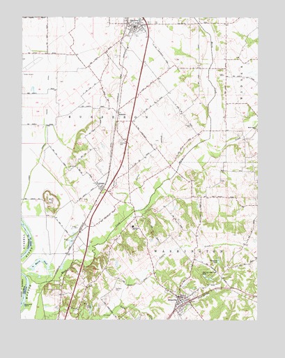
Oaktown, IN USGS Topographic Map
Click on map above to begin viewing in our Map Viewer.

This topographic map contains these locations and features:
Feature Name Type Latitude Longitude GNIS ID View Map
BrucevillePopulated PlaceN38.7595°W87.4156°431657View Map
Bruceville CemeteryCemeteryN38.7658°W87.4113°2769997View Map
BusseronPopulated PlaceN38.8356°W87.4492°431894View Map
Camp ArthurParkN38.7553°W87.4647°432008View Map
Charley CemeteryCemeteryN38.8303°W87.4108°432426View Map
Cleveland PondReservoirN38.7745°W87.3955°432649View Map
Cleveland Pond DamDamN38.7750°W87.3967°447749View Map
Cotton BranchStreamN38.7953°W87.4397°433018View Map
EmisonPopulated PlaceN38.8050°W87.4581°434167View Map
Emison Census Designated PlaceCensusN38.7991°W87.4604°2583451View Map
Hoke CemeteryCemeteryN38.7639°W87.4647°436301View Map
Light CemeteryCemeteryN38.8514°W87.3936°437880View Map
Lower Shaker Prairie DitchCanalN38.8517°W87.4856°438372View Map
Maria CreekStreamN38.7678°W87.4970°438602View Map
Maria Creek ChurchChurchN38.8295°W87.3759°438603View Map
Maria PondLakeN38.7740°W87.4906°438604View Map
North Knox West Elementary SchoolSchoolN38.7887°W87.4411°440269View Map
OaktownPopulated PlaceN38.8712°W87.4414°440482View Map
Oaktown Busseron Township Volunteer Fire DepartmentBuildingN38.8715°W87.4393°2625763View Map
Oaktown Police DepartmentBuildingN38.8710°W87.4409°2758254View Map
Ocheltree CemeteryCemeteryN38.8239°W87.4483°440497View Map
Price CemeteryCemeteryN38.8075°W87.3925°441590View Map
Rod and Gun Club DamDamN38.7687°W87.4036°447748View Map
Rod and Gun Club LakeReservoirN38.7683°W87.4031°442236View Map
Sevenmile IslandIslandN38.7548°W87.4995°443227View Map
Shaker PrairieFlatN38.8417°W87.4875°448380View Map
Shaker Prairie DitchCanalN38.8681°W87.4784°443268View Map
South Fork Smalls CreekStreamN38.7559°W87.4475°443813View Map
Threlkeld CemeteryCemeteryN38.7625°W87.4500°444746View Map
Town of BrucevilleCivilN38.7580°W87.4154°2396613View Map
Town of OaktownCivilN38.8717°W87.4412°2396827View Map
Township of BusseronCivilN38.8455°W87.4717°453147View Map
Township of WashingtonCivilN38.7678°W87.3939°454002View Map
Washington Township Volunteer Fire Department BrucevilleBuildingN38.7567°W87.4150°2625785View Map
Wolf HillSummitN38.7989°W87.4845°446249View Map

Note: Coordinates in the location and feature list above are referenced to NAD83 datum.


Copyright (C) 2008-2024 Ryan Niemi / Sunset Dynamics ... All Rights Reserved