TopoQuest Logo
Do you find TopoQuest useful?
Help keep TopoQuest running and adding new maps/features by donating!
Bitcoin:  19c7KJd3qBynnjoSw5npx9KScwjBe4ifkT
Litecoin:  LXs6TkuXGGXo1vDsWCkWVdjQX94eUKd6ui
Home View Maps Find Maps Find Places Resources & Links


Ogallala, Nebraska Topographic Map

USGS Map Title: Ogallala, NE
USGS Map MRC: 41101B6
DRG (GeoTIFF) Download: o41101b6.tif


Neighboring USGS Topographic Map Quads:


  Lemoyne, NE  
41101C7
 

  Martin, NE  
41101C6
 

  Glinn Ranch, NE  
41101C5
 

  Brule NE, NE  
41101B7
 

  Ogallala, NE  
41101B6
 

  Keystone, NE  
41101B5
 

  Brule SE, NE  
41101A7
 

  Ogallala SW, NE  
41101A6
 

  Ogallala SE, NE  
41101A5


Map MRC Location:

N42°
W102°
N42°
W101°
H8 H7 H6 H5 H4 H3 H2 H1
G8 G7 G6 G5 G4 G3 G2 G1
F8 F7 F6 F5 F4 F3 F2 F1
E8 E7 E6 E5 E4 E3 E2 E1
D8 D7 D6 D5 D4 D3 D2 D1
C8 C7 C6 C5 C4 C3 C2 C1
B8 B7 B6 B5 B4 B3 B2 B1
A8 A7 A6 A5 A4 A3 A2 A1
N41°
W102°
N41°
W101°

Ogallala, NE USGS 1:24K Topographic Map Preview:
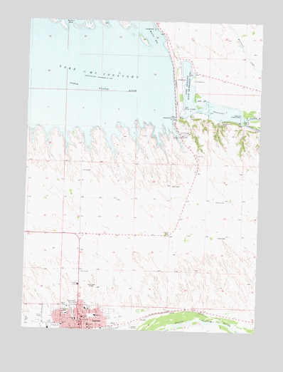
Ogallala, NE USGS Topographic Map
Click on map above to begin viewing in our Map Viewer.

This topographic map contains these locations and features:
Feature Name Type Latitude Longitude GNIS ID View Map
Anchor Baptist ChurchChurchN41.1280°W101.7196°1836157View Map
Arthur BayBayN41.2492°W101.7266°827063View Map
Berean Fundamental ChurchChurchN41.1292°W101.7005°1836159View Map
Boot Hill CemeteryCemeteryN41.1325°W101.7260°827563View Map
Boot Hill Historical MarkerParkN41.1328°W101.7255°1836237View Map
Caddi Shack CampgroundLocaleN41.2319°W101.6616°1836212View Map
Cedar Point CampLocaleN41.2092°W101.6468°828012View Map
Church of ChristChurchN41.1272°W101.7327°1836161View Map
Church of GodChurchN41.1305°W101.7277°1836162View Map
City of OgallalaCivilN41.1294°W101.7209°2395305View Map
Colister ParkParkN41.1297°W101.7080°1836174View Map
Cowboy Capital Historical MarkerParkN41.1280°W101.7196°1836236View Map
Cozy Country CoveLocaleN41.1280°W101.7196°1836207View Map
Cure Creek Dam 1-ADamN41.1367°W101.7088°1767170View Map
Cure Creek Reservoir 1-AReservoirN41.1375°W101.7092°1767171View Map
Ear Nose Throat and Sinus ClinicHospitalN41.1333°W101.7171°1836156View Map
Faith Evangelical Free ChurchChurchN41.1255°W101.7171°1836164View Map
Family Medical CenterHospitalN41.1333°W101.7174°1836151View Map
First Baptist ChurchChurchN41.1280°W101.7196°1836158View Map
First Congregational United Church of ChristChurchN41.1267°W101.7199°1836169View Map
Glines/Nye ParkParkN41.1333°W101.7255°1836178View Map
Goodall City LibraryBuildingN41.1258°W101.7202°1836140View Map
Goodall Recreation CenterBuildingN41.1300°W101.7102°1836150View Map
Humphreys PondParkN41.1258°W101.7043°1836175View Map
Indian Hills ManorHospitalN41.1430°W101.7210°1836149View Map
Jehovahs Witnesses Kingdom HallChurchN41.1278°W101.7074°1836165View Map
Keith CountyCivilN41.1988°W101.6614°835872View Map
Keith County CourthouseBuildingN41.1289°W101.7193°1836148View Map
Keith County FairgroundsLocaleN41.1255°W101.7324°1836134View Map
Keith County SheriffBuildingN41.1283°W101.7198°1836147View Map
Keystone Diversion DamDamN41.2117°W101.6363°830491View Map
Keystone Pond-Lake OgallalaReservoirN41.2150°W101.6355°1768767View Map
Kingsley DamDamN41.2230°W101.6721°830516View Map
Kingsley Dam Eagle Viewing FacilityBuildingN41.2111°W101.6685°1836133View Map
Kingsley Lodge CampgroundLocaleN41.2047°W101.6680°1836216View Map
KMCX-FM (Ogallala)TowerN41.1339°W101.6955°837421View Map
KOGA-AM (Ogallala)TowerN41.1422°W101.7138°837357View Map
L and L Mobile Home ParkPopulated PlaceN41.1280°W101.7196°1836146View Map
Lake Ogallala State Recreation AreaParkN41.2261°W101.6630°830589View Map
Lake Ogallala TrailTrailN41.2083°W101.6671°1836234View Map
Legion FieldParkN41.1333°W101.7255°1836177View Map
Lighthouse Baptist ChurchChurchN41.1258°W101.7088°1836172View Map
Mansion on the HillBuildingN41.1333°W101.7213°1836183View Map
Martin BayBayN41.2458°W101.6877°831067View Map
Nebraska National Trails MuseumBuildingN41.1255°W101.7121°1836182View Map
North ParkParkN41.1319°W101.7232°831717View Map
North Platte Foot ClinicHospitalN41.1333°W101.7171°1836155View Map
OgallalaPopulated PlaceN41.1280°W101.7196°831832View Map
Ogallala Beach CampgroundLocaleN41.2055°W101.7241°1836217View Map
Ogallala CemeteryCemeteryN41.1286°W101.7477°831833View Map
Ogallala Community HospitalHospitalN41.1512°W101.7188°1836153View Map
Ogallala Dam EastDamN41.1350°W101.7238°1768362View Map
Ogallala Dam WestDamN41.1350°W101.7321°1768363View Map
Ogallala High SchoolSchoolN41.1305°W101.7110°1836141View Map
Ogallala LakeLakeN41.2178°W101.6557°831835View Map
Ogallala Medical GroupHospitalN41.1278°W101.7199°1836139View Map
Ogallala Middle SchoolSchoolN41.1300°W101.7180°1836142View Map
Ogallala Police DeptBuildingN41.1265°W101.7150°1836144View Map
Ogallala Post OfficePost OfficeN41.1269°W101.7192°1836138View Map
Ogallala TrailTrailN41.1255°W101.7338°1836235View Map
Ogallala Volunteer Fire DepartmentBuildingN41.1264°W101.7153°1836145View Map
Pioneer ParkParkN41.1642°W101.6746°832125View Map
Platte Valley Diversion-1 DamDamN41.2150°W101.6355°1768766View Map
Prairie Mobile ClinicHospitalN41.1333°W101.7171°1836154View Map
Prairie View Elementary SchoolSchoolN41.1314°W101.7005°1836143View Map
Progress SchoolSchoolN41.1292°W101.7218°832399View Map
Radiant Life Assembly of God ChurchChurchN41.1361°W101.7282°1836173View Map
Saint Lukes Catholic ChurchChurchN41.1272°W101.7152°1836160View Map
Saint Lukes SchoolSchoolN41.1267°W101.7149°832964View Map
Saint Pauls Episcopal ChurchChurchN41.1272°W101.7188°1836163View Map
Saint Pauls Lutheran ChurchChurchN41.1253°W101.7224°1836166View Map
Saint Pauls SchoolSchoolN41.1258°W101.7199°833084View Map
School Number 18SchoolN41.1778°W101.6441°836328View Map
Searle ParkParkN41.1280°W101.7196°1836180View Map
Seventh Day Adventist ChurchChurchN41.1333°W101.7116°1836171View Map
Spillway BayBayN41.2069°W101.6727°1836214View Map
Spillway Bay CampgroundLocaleN41.2075°W101.6699°1836215View Map
Spillway ParkParkN41.1958°W101.6574°1836213View Map
United Methodist ChurchChurchN41.1280°W101.7193°1836167View Map
United Pentecostal ChurchChurchN41.1283°W101.7168°1836168View Map
Victory Baptist ChurchChurchN41.1292°W101.7155°1836170View Map
West 5th SchoolSchoolN41.1267°W101.7291°834558View Map
West ParkParkN41.1305°W101.7352°1836176View Map
Williams ParkParkN41.1486°W101.7213°1836179View Map

Note: Coordinates in the location and feature list above are referenced to NAD83 datum.


Copyright (C) 2008-2024 Ryan Niemi / Sunset Dynamics ... All Rights Reserved