TopoQuest Logo
Do you find TopoQuest useful?
Help keep TopoQuest running and adding new maps/features by donating!
Bitcoin:  19c7KJd3qBynnjoSw5npx9KScwjBe4ifkT
Litecoin:  LXs6TkuXGGXo1vDsWCkWVdjQX94eUKd6ui
Home View Maps Find Maps Find Places Resources & Links


Bend, South Dakota Topographic Map

USGS Map Title: Bend, SD
USGS Map MRC: 44103B1
DRG (GeoTIFF) Download: o44103b1.tif


Neighboring USGS Topographic Map Quads:


  Cottonwood Draw, SD  
44103C2
 

  Lone Tree Creek, SD  
44103C1
 

  Hereford SW, SD  
44102C8
 

  Rapid City NW, SD  
44103B2
 

  Bend, SD  
44103B1
 

  New Underwood NW, SD  
44102B8
 

  Rapid City East, SD  
44103A2
 

  Box Elder, SD  
44103A1
 

  New Underwood SW, SD  
44102A8


Map MRC Location:

N45°
W104°
N45°
W103°
H8 H7 H6 H5 H4 H3 H2 H1
G8 G7 G6 G5 G4 G3 G2 G1
F8 F7 F6 F5 F4 F3 F2 F1
E8 E7 E6 E5 E4 E3 E2 E1
D8 D7 D6 D5 D4 D3 D2 D1
C8 C7 C6 C5 C4 C3 C2 C1
B8 B7 B6 B5 B4 B3 B2 B1
A8 A7 A6 A5 A4 A3 A2 A1
N44°
W104°
N44°
W103°

Bend, SD USGS 1:24K Topographic Map Preview:
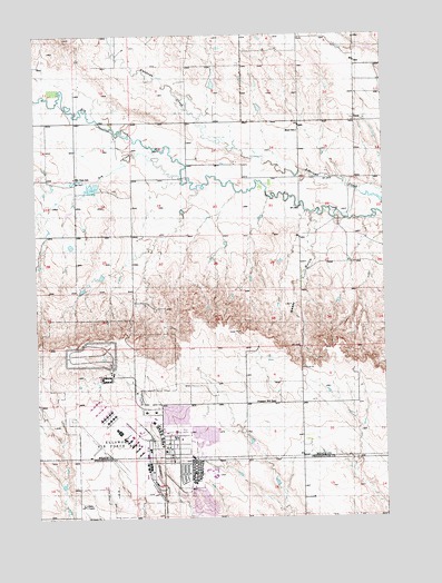
Bend, SD USGS Topographic Map
Click on map above to begin viewing in our Map Viewer.

This topographic map contains these locations and features:
Feature Name Type Latitude Longitude GNIS ID View Map
Badger Clark/Carrousel Elementary SchoolSchoolN44.1376°W103.0649°2728595View Map
BendPopulated PlaceN44.2278°W103.0102°1260981View Map
Bend SchoolSchoolN44.2250°W103.0310°1253848View Map
Box Elder City HallBuildingN44.1343°W103.0699°2724688View Map
Box Elder Police DepartmentBuildingN44.1334°W103.0643°2755461View Map
Box Elder Post OfficePost OfficeN44.1340°W103.0715°2709685View Map
Douglas High SchoolSchoolN44.1357°W103.0619°2728596View Map
Douglas Middle SchoolSchoolN44.1394°W103.0620°2728597View Map
Dry CreekStreamN44.2125°W103.0727°1254758View Map
Elk Dale SchoolSchoolN44.2130°W103.1110°1254904View Map
Ellsworth Air Force BaseMilitaryN44.1510°W103.0949°2512175View Map
Ellsworth Air Force BaseAirportN44.1449°W103.0979°2443984View Map
Ellsworth Air Force Base Census Designated Place (historical)CensusN44.1439°W103.0751°2392990View Map
Ellsworth Air Force Base Fire DepartmentBuildingN44.1463°W103.0946°2580810View Map
Francis Case Elementary SchoolSchoolN44.1375°W103.0613°2728598View Map
Pleasant Hill SchoolSchoolN44.1547°W103.0402°1257110View Map
Running Colors AirportAirportN44.1993°W103.0803°2443983View Map
South Dakota Air and Space MuseumBuildingN44.1336°W103.0731°2728664View Map
Sweet GulchValleyN44.2035°W103.0262°1258476View Map
Vandenberg Elementary SchoolSchoolN44.1408°W103.0698°2728599View Map
Villa Ranchero Shopping CenterLocaleN44.1347°W103.0699°1259528View Map

Note: Coordinates in the location and feature list above are referenced to NAD83 datum.


Copyright (C) 2008-2025 Ryan Niemi / Sunset Dynamics ... All Rights Reserved