TopoQuest Logo
Do you find TopoQuest useful?
Help keep TopoQuest running and adding new maps/features by donating!
Bitcoin:  19c7KJd3qBynnjoSw5npx9KScwjBe4ifkT
Litecoin:  LXs6TkuXGGXo1vDsWCkWVdjQX94eUKd6ui
Home View Maps Find Maps Find Places Resources & Links


Onehorse Slough, Oregon Topographic Map

USGS Map Title: Onehorse Slough, OR
USGS Map MRC: 44122E7
DRG (GeoTIFF) Download: o44122e7.tif


Neighboring USGS Topographic Map Quads:


  Crabtree, OR  
44122F8
 

  Scio, OR  
44122F7
 

  Jordan, OR  
44122F6
 

  Lebanon, OR  
44122E8
 

  Onehorse Slough, OR  
44122E7
 

  Lacomb, OR  
44122E6
 

  Brownsville, OR  
44122D8
 

  Waterloo, OR  
44122D7
 

  Sweet Home, OR  
44122D6


Map MRC Location:

N45°
W123°
N45°
W122°
H8 H7 H6 H5 H4 H3 H2 H1
G8 G7 G6 G5 G4 G3 G2 G1
F8 F7 F6 F5 F4 F3 F2 F1
E8 E7 E6 E5 E4 E3 E2 E1
D8 D7 D6 D5 D4 D3 D2 D1
C8 C7 C6 C5 C4 C3 C2 C1
B8 B7 B6 B5 B4 B3 B2 B1
A8 A7 A6 A5 A4 A3 A2 A1
N44°
W123°
N44°
W122°

Onehorse Slough, OR USGS 1:24K Topographic Map Preview:
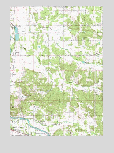
Onehorse Slough, OR USGS Topographic Map
Click on map above to begin viewing in our Map Viewer.

This topographic map contains these locations and features:
Feature Name Type Latitude Longitude GNIS ID View Map
Abberdeen Post Office (historical)Post OfficeN44.5679°W122.7854°1164167View Map
Barr BridgeBridgeN44.5771°W122.8423°1162618View Map
Bellinger CemeteryCemeteryN44.5273°W122.7873°1117500View Map
Berthelson PondLakeN44.5922°W122.7684°1130587View Map
Brewster (historical)LocaleN44.5801°W122.8684°1136092View Map
Calvins PondLakeN44.5940°W122.7561°1130586View Map
Carter CreekStreamN44.5735°W122.7870°1118633View Map
Clarks PondLakeN44.5468°W122.8041°1130589View Map
Claypool BridgeBridgeN44.5921°W122.8690°1851673View Map
Cold Spring CreekStreamN44.6040°W122.8254°1119116View Map
Davenport PondReservoirN44.5939°W122.7778°1119698View Map
First CreekStreamN44.5168°W122.8531°1120743View Map
Golden ValleyValleyN44.5465°W122.8718°1121222View Map
GriggsLocaleN44.6062°W122.8715°1143089View Map
Griggs School (historical)SchoolN44.6048°W122.8723°1638829View Map
Hamilton CreekStreamN44.5160°W122.8540°1121535View Map
Hamilton Creek SchoolSchoolN44.5134°W122.8357°1121537View Map
Johnson LakeReservoirN44.5695°W122.7938°1162617View Map
Kelley Timber Products (historical)LocaleN44.5010°W122.8545°1637798View Map
Lebanon DamDamN44.5165°W122.8628°1158319View Map
Lebanon SubstationLocaleN44.5043°W122.8654°1123017View Map
Little ReservoirReservoirN44.5844°W122.7666°1130588View Map
Long PassLocaleN44.5054°W122.8729°1136497View Map
Mt Hope AirportAirportN44.5583°W122.8275°2645987View Map
Mystery Hills ReservoirReservoirN44.6075°W122.7577°1130585View Map
Onehorse SloughStreamN44.5915°W122.8698°1124996View Map
Ornoname 5 DamDamN44.5965°W122.8695°1163800View Map
Pacific Northwest Moulding Company (historical)LocaleN44.5026°W122.8609°1637797View Map
Providence CemeteryCemeteryN44.6243°W122.8027°1125680View Map
Ridgeway ButteSummitN44.5262°W122.8745°1126002View Map
Snow Peak Log PondReservoirN44.5953°W122.8669°1136963View Map
Taylor ReservoirReservoirN44.5364°W122.7911°1130590View Map
Vail CreekStreamN44.5107°W122.8520°1128492View Map
Western Log PondReservoirN44.6020°W122.8679°1136962View Map
Western Veneer and Plywood DamDamN44.6048°W122.8679°1133712View Map
WhitakerPopulated PlaceN44.5585°W122.8731°1136900View Map
Willamette Industries Wastewater Treatment PlantLocaleN44.6061°W122.8708°2697061View Map

Note: Coordinates in the location and feature list above are referenced to NAD83 datum.


Copyright (C) 2008-2024 Ryan Niemi / Sunset Dynamics ... All Rights Reserved