TopoQuest Logo
Do you find TopoQuest useful?
Help keep TopoQuest running and adding new maps/features by donating!
Bitcoin:  19c7KJd3qBynnjoSw5npx9KScwjBe4ifkT
Litecoin:  LXs6TkuXGGXo1vDsWCkWVdjQX94eUKd6ui
Home View Maps Find Maps Find Places Resources & Links


Orchard, Colorado Topographic Map

USGS Map Title: Orchard, CO
USGS Map MRC: 40104C1
DRG (GeoTIFF) Download: o40104c1.tif


Neighboring USGS Topographic Map Quads:


  Greasewood Lake, CO  
40104D2
 

  Sunken Lake, CO  
40104D1
 

  Judson Hills, CO  
40103D8
 

  Masters, CO  
40104C2
 

  Orchard, CO  
40104C1
 

  Weldona, CO  
40103C8
 

  Omar, CO  
40104B2
 

  Wiggins, CO  
40104B1
 

  Vallery, CO  
40103B8


Map MRC Location:

N41°
W105°
N41°
W104°
H8 H7 H6 H5 H4 H3 H2 H1
G8 G7 G6 G5 G4 G3 G2 G1
F8 F7 F6 F5 F4 F3 F2 F1
E8 E7 E6 E5 E4 E3 E2 E1
D8 D7 D6 D5 D4 D3 D2 D1
C8 C7 C6 C5 C4 C3 C2 C1
B8 B7 B6 B5 B4 B3 B2 B1
A8 A7 A6 A5 A4 A3 A2 A1
N40°
W105°
N40°
W104°

Orchard, CO USGS 1:24K Topographic Map Preview:
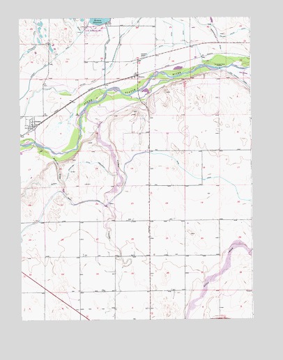
Orchard, CO USGS Topographic Map
Click on map above to begin viewing in our Map Viewer.

This topographic map contains these locations and features:
Feature Name Type Latitude Longitude GNIS ID View Map
Bijou CanalCanalN40.3166°W104.0644°180752View Map
Cottonwood DrawValleyN40.3595°W104.0135°180685View Map
Fort Morgan Canal HeadgateDamN40.3541°W104.0166°180772View Map
GoodrichPopulated PlaceN40.3511°W104.0616°180769View Map
Goodrich SchoolSchoolN40.3589°W104.0591°180768View Map
Jackson LakeReservoirN40.3733°W104.0788°198211View Map
Jackson Lake Census Designated PlaceCensusN40.3642°W104.0719°2583251View Map
Jackson Lake DamDamN40.3733°W104.0788°198210View Map
Jackson Lake OutletCanalN40.3583°W104.0788°180767View Map
Kiowa CreekStreamN40.3364°W104.0897°201758View Map
Kiowa DamDamN40.3366°W104.0905°198214View Map
Kiowa ReservoirReservoirN40.3366°W104.0905°198215View Map
Milliron DrawValleyN40.3187°W104.1058°180765View Map
OrchardPopulated PlaceN40.3311°W104.1183°180764View Map
Orchard Census Designated PlaceCensusN40.3320°W104.1178°2583274View Map
Orchard Post OfficePost OfficeN40.3327°W104.1174°2736034View Map
Putman Irrigation DitchCanalN40.3080°W104.1005°180766View Map
Seiber DairyLocaleN40.2708°W104.1092°2705262View Map
Weldon Valley DitchCanalN40.3694°W104.1005°182898View Map

Note: Coordinates in the location and feature list above are referenced to NAD83 datum.


Copyright (C) 2008-2025 Ryan Niemi / Sunset Dynamics ... All Rights Reserved