TopoQuest Logo
Do you find TopoQuest useful?
Help keep TopoQuest running and adding new maps/features by donating!
Bitcoin:  19c7KJd3qBynnjoSw5npx9KScwjBe4ifkT
Litecoin:  LXs6TkuXGGXo1vDsWCkWVdjQX94eUKd6ui
Home View Maps Find Maps Find Places Resources & Links


Oreana Peak, Nevada Topographic Map

USGS Map Title: Oreana Peak, NV
USGS Map MRC: 38119G4
DRG (GeoTIFF) Download: o38119g4.tif


Neighboring USGS Topographic Map Quads:


  Mount Siegel, NV  
38119H5
 

  Pine Nut Valley, NV  
38119H4
 

  Artesia Lake, NV  
38119H3
 

  Double Spring, NV  
38119G5
 

  Oreana Peak, NV  
38119G4
 

  Smith, NV  
38119G3
 

  Topaz Lake, NV  
38119F5
 

  Long Dry Canyon, NV  
38119F4
 

  Desert Creek Ranch, NV  
38119F3


Map MRC Location:

N39°
W120°
N39°
W119°
H8 H7 H6 H5 H4 H3 H2 H1
G8 G7 G6 G5 G4 G3 G2 G1
F8 F7 F6 F5 F4 F3 F2 F1
E8 E7 E6 E5 E4 E3 E2 E1
D8 D7 D6 D5 D4 D3 D2 D1
C8 C7 C6 C5 C4 C3 C2 C1
B8 B7 B6 B5 B4 B3 B2 B1
A8 A7 A6 A5 A4 A3 A2 A1
N38°
W120°
N38°
W119°

Oreana Peak, NV USGS 1:24K Topographic Map Preview:
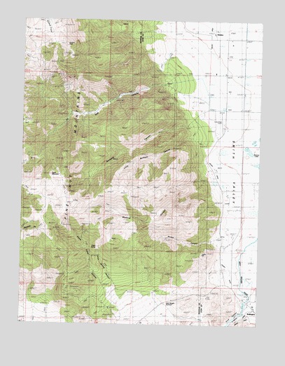
Oreana Peak, NV USGS Topographic Map
Click on map above to begin viewing in our Map Viewer.

This topographic map contains these locations and features:
Feature Name Type Latitude Longitude GNIS ID View Map
Acciari RanchLocaleN38.8144°W119.3993°847950View Map
Beaman LakesLakeN38.8219°W119.3802°863909View Map
Burbank CanyonValleyN38.8327°W119.4107°839198View Map
China SpringSpringN38.7802°W119.4593°839493View Map
China Spring CanyonValleyN38.7660°W119.4499°839497View Map
Colony DitchCanalN38.8177°W119.4029°863914View Map
Eagle MountainSummitN38.8171°W119.4771°848540View Map
Farias Wheel AirportAirportN38.8358°W119.3951°864136View Map
Granton RanchLocaleN38.7969°W119.3921°847951View Map
Hoye (historical)Populated PlaceN38.7605°W119.3832°847925View Map
Hoye CanyonValleyN38.7557°W119.3846°860063View Map
Jack Wright SummitSummitN38.7557°W119.4293°841329View Map
Little Burbank CanyonValleyN38.8274°W119.4107°841669View Map
Lucky Bill MineMineN38.8516°W119.4860°855137View Map
Oreana PeakSummitN38.8649°W119.4782°842633View Map
Red CanyonValleyN38.8488°W119.4257°848626View Map
Red Canyon MineMineN38.8485°W119.4260°853074View Map
Rickey CanyonValleyN38.7852°W119.3974°843217View Map
Silver Glance Mining DistrictCivilN38.7632°W119.4441°848436View Map
SimpsonPopulated PlaceN38.8694°W119.3993°858188View Map
Simpson Post Office (historical)Post OfficeN38.8694°W119.3993°864551View Map
Simpson RanchLocaleN38.8694°W119.4010°847952View Map
Smith Valley Fire Protection District Station 41BuildingN38.7552°W119.3760°2581339View Map
Smith Valley Fire Protection District Station 42BuildingN38.8387°W119.3909°2581340View Map
South Camp CanyonValleyN38.7657°W119.4571°843833View Map
South Camp MineMineN38.7910°W119.4793°863808View Map
Taylor HillSummitN38.7796°W119.4043°845696View Map
Taylor Hill MineMineN38.7782°W119.4093°855138View Map
Valley View Landing Strip (historical)AirportN38.8335°W119.4052°848045View Map
Wedertz CanyonValleyN38.8030°W119.3999°844689View Map
WellingtonPopulated PlaceN38.7563°W119.3760°848674View Map
Wellington Post OfficePost OfficeN38.7563°W119.3763°864552View Map
Winters MineMineN38.8738°W119.4816°845002View Map
Wrights Bridge (historical)BridgeN38.7599°W119.3821°847979View Map
Wyandotte MineMineN38.8363°W119.4774°855151View Map
Yankee Girl MineMineN38.7638°W119.4441°853072View Map

Note: Coordinates in the location and feature list above are referenced to NAD83 datum.


Copyright (C) 2008-2024 Ryan Niemi / Sunset Dynamics ... All Rights Reserved