TopoQuest Logo
Do you find TopoQuest useful?
Help keep TopoQuest running and adding new maps/features by donating!
Bitcoin:  19c7KJd3qBynnjoSw5npx9KScwjBe4ifkT
Litecoin:  LXs6TkuXGGXo1vDsWCkWVdjQX94eUKd6ui
Home View Maps Find Maps Find Places Resources & Links


Oxford, Alabama Topographic Map

USGS Map Title: Oxford, AL
USGS Map MRC: 33085E7
DRG (GeoTIFF) Download: o33085e7.tif


Neighboring USGS Topographic Map Quads:


  Eulaton, AL  
33085F8
 

  Anniston, AL  
33085F7
 

  Choccolocco, AL  
33085F6
 

  Munford, AL  
33085E8
 

  Oxford, AL  
33085E7
 

  Hollis Crossroads, AL  
33085E6
 

  Ironaton, AL  
33085D8
 

  Cheaha Mountain, AL  
33085D7
 

  Delta, AL  
33085D6


Map MRC Location:

N34°
W86°
N34°
W85°
H8 H7 H6 H5 H4 H3 H2 H1
G8 G7 G6 G5 G4 G3 G2 G1
F8 F7 F6 F5 F4 F3 F2 F1
E8 E7 E6 E5 E4 E3 E2 E1
D8 D7 D6 D5 D4 D3 D2 D1
C8 C7 C6 C5 C4 C3 C2 C1
B8 B7 B6 B5 B4 B3 B2 B1
A8 A7 A6 A5 A4 A3 A2 A1
N33°
W86°
N33°
W85°

Oxford, AL USGS 1:24K Topographic Map Preview:
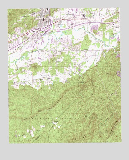
Oxford, AL USGS Topographic Map
Click on map above to begin viewing in our Map Viewer.

This topographic map contains these locations and features:
Feature Name Type Latitude Longitude GNIS ID View Map
Alberts BranchStreamN33.5023°W85.8666°162387View Map
Anniston Fire Department Station 6BuildingN33.5894°W85.8528°2683043View Map
Anniston Regional AirportAirportN33.5903°W85.8525°161281View Map
Anniston SpeedwayLocaleN33.6209°W85.7708°162135View Map
Antioch Baptist ChurchChurchN33.5596°W85.8397°159073View Map
Antioch CemeteryCemeteryN33.5601°W85.8391°162243View Map
Bethlehem CemeteryCemeteryN33.5804°W85.7697°162140View Map
Bethlehem Missionary Baptist ChurchChurchN33.5807°W85.7689°159166View Map
Bible Baptist ChurchChurchN33.6154°W85.8075°162142View Map
Blue MountainSummitN33.5054°W85.7911°159212View Map
Blue PondLakeN33.6102°W85.8052°159213View Map
Blue PondPopulated PlaceN33.6118°W85.8041°162144View Map
Blue SpringSpringN33.6037°W85.8352°162897View Map
Blue Spring Baptist ChurchChurchN33.5973°W85.8414°162145View Map
Boiling SpringPopulated PlaceN33.6148°W85.7927°159230View Map
Boiling SpringSpringN33.6084°W85.7894°162898View Map
Boiling Springs Methodist Church (historical)ChurchN33.6157°W85.7964°162840View Map
Brock MountainSummitN33.5712°W85.8450°159250View Map
Buck Horn ValleyValleyN33.5690°W85.8644°162403View Map
Buckalew BridgeBridgeN33.6001°W85.7575°162841View Map
Calhoun County Training SchoolSchoolN33.6209°W85.8452°162150View Map
Calvary Baptist ChurchChurchN33.6148°W85.8333°162151View Map
Cheaha AcresPopulated PlaceN33.5890°W85.8230°162152View Map
Chinnabee (historical)Populated PlaceN33.5976°W85.8180°162846View Map
Choccolocco Creek Sewage Treatment PlantLocaleN33.6029°W85.8277°162153View Map
Church of GodChurchN33.5979°W85.8458°162158View Map
Church of GodChurchN33.6201°W85.8375°162160View Map
Church of GodChurchN33.6193°W85.8355°162161View Map
City of OxfordCivilN33.5963°W85.8721°2404451View Map
Dodson Memorial Presbyterian ChurchChurchN33.6123°W85.8355°162173View Map
Dry BranchStreamN33.5762°W85.8672°159517View Map
Duck Nest Hunten CampLocaleN33.5073°W85.8316°163109View Map
Duck Nest SpringsLocaleN33.5198°W85.8252°159533View Map
Exit 185CrossingN33.6051°W85.8308°163042View Map
Exit 188CrossingN33.6114°W85.7861°2130655View Map
Faith Childrens Home MissionChurchN33.5884°W85.8727°162175View Map
First Baptist Church of OxfordChurchN33.6165°W85.8339°162177View Map
Forest HillsPopulated PlaceN33.6048°W85.8680°162180View Map
FriendshipPopulated PlaceN33.5848°W85.7902°162181View Map
Friendship Elementary SchoolSchoolN33.5848°W85.7858°159640View Map
Grace Baptist ChurchChurchN33.5948°W85.8155°162184View Map
Grace ChurchChurchN33.6034°W85.8297°159687View Map
Harry M Ayres State Technical SchoolSchoolN33.6229°W85.8022°162186View Map
HicksPopulated PlaceN33.5809°W85.7775°159768View Map
Hillabee CreekStreamN33.5887°W85.7627°159776View Map
Hobson CityPopulated PlaceN33.6215°W85.8441°159780View Map
Hobson City ParkParkN33.6193°W85.8422°162187View Map
House (historical)Populated PlaceN33.5904°W85.8527°162861View Map
Jo DellPopulated PlaceN33.6101°W85.8216°162192View Map
KentuckPopulated PlaceN33.5309°W85.8305°159888View Map
Kentuck Lookout TowerTowerN33.5296°W85.8386°164531View Map
Kentuck MountainRidgeN33.5301°W85.8361°159889View Map
Kentuck Ranger StationLocaleN33.5298°W85.8391°159890View Map
Kilgoe MountainSummitN33.5640°W85.7622°159895View Map
LakeviewPopulated PlaceN33.6134°W85.8216°162194View Map
Lakeview ChurchChurchN33.6132°W85.8205°159908View Map
LardentPopulated PlaceN33.6223°W85.8294°162195View Map
Little Hillabee CreekStreamN33.5879°W85.7558°159971View Map
Marble SpringsSpringN33.6090°W85.8166°162198View Map
McAdingPopulated PlaceN33.5612°W85.8311°160065View Map
McKibbenPopulated PlaceN33.5995°W85.8683°162199View Map
McKibbon (historical)LocaleN33.5848°W85.8666°162480View Map
MeadowbrookPopulated PlaceN33.5932°W85.8644°162200View Map
Meadowbrook Baptist ChurchChurchN33.5973°W85.8639°162201View Map
New Hope Missionary Baptist ChurchChurchN33.6195°W85.8375°162206View Map
Oak HillSummitN33.5034°W85.8022°160273View Map
Oak HillPopulated PlaceN33.5851°W85.8144°162499View Map
Oak Hill ChurchChurchN33.5851°W85.8155°160277View Map
Oak MountainSummitN33.6209°W85.8711°160279View Map
Oak Ridge Baptist ChurchChurchN33.6195°W85.8480°160280View Map
Oconee Baptist Church (historical)ChurchN33.6157°W85.7964°162874View Map
Oconee CemeteryCemeteryN33.6154°W85.7952°162208View Map
Old Mill Mall Shopping CenterLocaleN33.6068°W85.8319°162209View Map
OxfordPopulated PlaceN33.6143°W85.8350°160330View Map
Oxford Church of ChristChurchN33.6154°W85.8325°162210View Map
Oxford Civic CenterBuildingN33.6073°W85.8172°162211View Map
Oxford Elementary SchoolSchoolN33.6115°W85.8316°162212View Map
Oxford Fire Department Station 1BuildingN33.6093°W85.8361°2683010View Map
Oxford Fire Department Station 2BuildingN33.5867°W85.8036°2683085View Map
Oxford Fire Department Station 4BuildingN33.6217°W85.7510°2683111View Map
Oxford High SchoolSchoolN33.6126°W85.8322°162213View Map
Oxford LakeLakeN33.6090°W85.8156°160331View Map
Oxford Memorial Gardens CemeteryCemeteryN33.6176°W85.8422°162214View Map
Oxford Middle SchoolSchoolN33.5945°W85.8683°140995View Map
Oxford Police DepartmentBuildingN33.6000°W85.8631°2751828View Map
Oxford Post OfficePost OfficeN33.5997°W85.8348°2788955View Map
Oxford StadiumParkN33.6095°W85.8314°162215View Map
Parker MineMineN33.5007°W85.8583°162504View Map
Pine MountainSummitN33.5251°W85.7902°160381View Map
Pine Ridge CemeteryCemeteryN33.5857°W85.8019°162509View Map
Pine Ridge ChurchChurchN33.5859°W85.8022°162221View Map
Pure Holiness ChurchChurchN33.5773°W85.8208°160457View Map
Quintard Mall Shopping CenterLocaleN33.6126°W85.8258°162224View Map
Rising Star Methodist ChurchChurchN33.6229°W85.8372°160494View Map
Robertson DamDamN33.6007°W85.7769°161443View Map
Robertsons LakeReservoirN33.6014°W85.7750°161444View Map
Rush DamDamN33.5968°W85.7516°161439View Map
Rushs LakeReservoirN33.5967°W85.7526°161440View Map
Salt Creek ChurchChurchN33.5104°W85.8525°160554View Map
Sky City Shopping CenterLocaleN33.6137°W85.8064°162230View Map
Sunny Eve Baptist ChurchChurchN33.6076°W85.7508°160694View Map
Sweet Rock Baptist ChurchChurchN33.5757°W85.8216°160700View Map
Town of Hobson CityCivilN33.6190°W85.8540°2405845View Map
TrinityPopulated PlaceN33.5895°W85.8689°160755View Map
Trinity Baptist ChurchChurchN33.5893°W85.8730°162234View Map
Trinity Christian AcademySchoolN33.5890°W85.8739°162235View Map
Trinity School (historical)SchoolN33.5893°W85.8730°162882View Map
Welcome Chapel ChurchChurchN33.6209°W85.8369°162236View Map
Wolfskull CreekStreamN33.5965°W85.8189°162241View Map

Note: Coordinates in the location and feature list above are referenced to NAD83 datum.


Copyright (C) 2008-2024 Ryan Niemi / Sunset Dynamics ... All Rights Reserved