TopoQuest Logo
Do you find TopoQuest useful?
Help keep TopoQuest running and adding new maps/features by donating!
Bitcoin:  19c7KJd3qBynnjoSw5npx9KScwjBe4ifkT
Litecoin:  LXs6TkuXGGXo1vDsWCkWVdjQX94eUKd6ui
Home View Maps Find Maps Find Places Resources & Links


Benton, Alabama Topographic Map

USGS Map Title: Benton, AL
USGS Map MRC: 32086C7
DRG (GeoTIFF) Download: o32086c7.tif


Neighboring USGS Topographic Map Quads:


  Burnsville, AL  
32086D8
 

  Durant Bend, AL  
32086D7
 

  Autaugaville, AL  
32086D6
 

  Sardis, AL  
32086C8
 

  Benton, AL  
32086C7
 

  White Hall, AL  
32086C6
 

  Pleasant Hill, AL  
32086B8
 

  Collirene, AL  
32086B7
 

  Gordonsville, AL  
32086B6


Map MRC Location:

N33°
W87°
N33°
W86°
H8 H7 H6 H5 H4 H3 H2 H1
G8 G7 G6 G5 G4 G3 G2 G1
F8 F7 F6 F5 F4 F3 F2 F1
E8 E7 E6 E5 E4 E3 E2 E1
D8 D7 D6 D5 D4 D3 D2 D1
C8 C7 C6 C5 C4 C3 C2 C1
B8 B7 B6 B5 B4 B3 B2 B1
A8 A7 A6 A5 A4 A3 A2 A1
N32°
W87°
N32°
W86°

Benton, AL USGS 1:24K Topographic Map Preview:
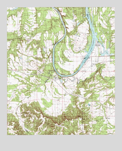
Benton, AL USGS Topographic Map
Click on map above to begin viewing in our Map Viewer.

This topographic map contains these locations and features:
Feature Name Type Latitude Longitude GNIS ID View Map
B C Rhyne DamDamN32.3051°W86.8116°130396View Map
B C Rhyne LakeReservoirN32.3031°W86.8120°130397View Map
Bar Below BentonBarN32.3204°W86.8219°136315View Map
BentonPopulated PlaceN32.3068°W86.8178°113937View Map
Benton LandingLocaleN32.3090°W86.8111°147526View Map
Benton Post OfficePost OfficeN32.3057°W86.8178°168215View Map
Big Elam Church (historical)ChurchN32.3546°W86.7939°147529View Map
Big Swamp CreekStreamN32.3074°W86.8125°149933View Map
Camp CreekStreamN32.3626°W86.8128°115457View Map
Camp Creek ChurchChurchN32.3385°W86.8514°115458View Map
Days BendBendN32.3326°W86.7953°117150View Map
Dulaney SchoolSchoolN32.2890°W86.7905°117645View Map
EdsonsPopulated PlaceN32.3182°W86.7753°117874View Map
Elam Church (historical)ChurchN32.3404°W86.7986°147554View Map
Ellwood ChurchChurchN32.2932°W86.8667°155059View Map
Ellwood School (historical)SchoolN32.2929°W86.8669°144557View Map
Good Hope CemeteryCemeteryN32.2662°W86.7883°136360View Map
Good Hope ChurchChurchN32.2707°W86.7719°136361View Map
Gunters FarmLocaleN32.3154°W86.8072°147574View Map
J Smiths Landing (historical)LocaleN32.3071°W86.8091°136376View Map
M A Richard DamDamN32.3485°W86.7933°130470View Map
Mount Gilead CemeteryCemeteryN32.2715°W86.7603°136410View Map
Mount Gillard CemeteryCemeteryN32.2718°W86.7603°164083View Map
Mount Nebo ChurchChurchN32.2624°W86.8366°123270View Map
Mount Sinai ChurchChurchN32.2885°W86.7903°136415View Map
New Mount Moriah ChurchChurchN32.3657°W86.8589°123867View Map
Old Town CreekStreamN32.3129°W86.8194°124262View Map
PetroniaPopulated PlaceN32.2660°W86.7886°152879View Map
Pilgrim Church (historical)ChurchN32.3132°W86.8430°136426View Map
Prairie CreekStreamN32.3454°W86.7722°136434View Map
Prairie Creek Public Land UseParkN32.3376°W86.7694°136435View Map
Richard LakeReservoirN32.3470°W86.7936°130469View Map
Robert F Henry Lock and DamDamN32.3245°W86.7846°120977View Map
Robert Rives CemeteryCemeteryN32.2651°W86.8019°136440View Map
Talisi (historical)LocaleN32.3043°W86.8166°136460View Map
Town of BentonCivilN32.3078°W86.8180°2405243View Map
Upchurch Lake DamDamN32.3485°W86.8016°130471View Map
Valley CreekStreamN32.3013°W86.8311°136470View Map
Weeping Willow ChurchChurchN32.3454°W86.8539°153918View Map
Wood LandingLocaleN32.3549°W86.8069°147677View Map

Note: Coordinates in the location and feature list above are referenced to NAD83 datum.


Copyright (C) 2008-2025 Ryan Niemi / Sunset Dynamics ... All Rights Reserved