TopoQuest Logo
Do you find TopoQuest useful?
Help keep TopoQuest running and adding new maps/features by donating!
Bitcoin:  19c7KJd3qBynnjoSw5npx9KScwjBe4ifkT
Litecoin:  LXs6TkuXGGXo1vDsWCkWVdjQX94eUKd6ui
Home View Maps Find Maps Find Places Resources & Links


Palmer Lake, Colorado Topographic Map

USGS Map Title: Palmer Lake, CO
USGS Map MRC: 39104A8
DRG (GeoTIFF) Download: o39104a8.tif


Neighboring USGS Topographic Map Quads:


  Dakan Mountain, CO  
39105B1
 

  Larkspur, CO  
39104B8
 

  Greenland, CO  
39104B7
 

  Mount Deception, CO  
39105A1
 

  Palmer Lake, CO  
39104A8
 

  Monument, CO  
39104A7
 

  Woodland Park, CO  
38105H1
 

  Cascade, CO  
38104H8
 

  Pikeview, CO  
38104H7


Map MRC Location:

N40°
W105°
N40°
W104°
H8 H7 H6 H5 H4 H3 H2 H1
G8 G7 G6 G5 G4 G3 G2 G1
F8 F7 F6 F5 F4 F3 F2 F1
E8 E7 E6 E5 E4 E3 E2 E1
D8 D7 D6 D5 D4 D3 D2 D1
C8 C7 C6 C5 C4 C3 C2 C1
B8 B7 B6 B5 B4 B3 B2 B1
A8 A7 A6 A5 A4 A3 A2 A1
N39°
W105°
N39°
W104°

Palmer Lake, CO USGS 1:24K Topographic Map Preview:
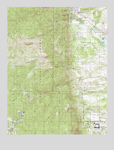
Palmer Lake, CO USGS Topographic Map
Click on map above to begin viewing in our Map Viewer.

This topographic map contains these locations and features:
Feature Name Type Latitude Longitude GNIS ID View Map
Air Force Academy Recreation AreaParkN39.0105°W104.9953°193223View Map
Aspen LakeReservoirN39.0127°W104.9850°198915View Map
Aspen Lake DamDamN39.0133°W104.9855°198914View Map
Balanced Rock TrailTrailN39.0936°W104.9469°193239View Map
Beaver Creek RanchLocaleN39.0614°W104.9011°193255View Map
Ben Lomand MountainSummitN39.1217°W104.9036°193241View Map
Boulder LakeReservoirN39.0156°W104.9849°193228View Map
Cadet Post OfficePost OfficeN39.0097°W104.8866°2759216View Map
Carrol LakesReservoirN39.0139°W104.9844°193224View Map
Cathedral RockSummitN39.0294°W104.9014°193261View Map
Chautauqua MountainSummitN39.1128°W104.9303°193234View Map
Columbine DamDamN39.0183°W104.9855°198928View Map
Columbine LakeReservoirN39.0179°W104.9842°198929View Map
Cononame 4 DamDamN39.0150°W104.8922°200487View Map
Crystal CreekStreamN39.0928°W104.8780°193265View Map
Deadmans LakeLakeN39.0242°W104.8993°197434View Map
Dirty Woman CreekStreamN39.0825°W104.8764°193269View Map
Elephant RockSummitN39.1186°W104.8905°193242View Map
Elephant Rock ArchArchN39.1186°W104.8908°1678977View Map
Ensign GulchValleyN39.0403°W104.9780°183875View Map
Gem LakeReservoirN39.0193°W104.9826°193230View Map
Glen ParkPopulated PlaceN39.1144°W104.9203°193235View Map
Goat Camp CreekStreamN39.0175°W104.8766°193260View Map
Grace LakeReservoirN39.0123°W104.9946°193226View Map
Green Mountain RanchLocaleN39.0486°W104.9000°193254View Map
Hell CreekStreamN39.0592°W104.9019°193256View Map
Ice Cave CreekStreamN39.1164°W104.9336°183876View Map
Lake LodgeReservoirN39.0117°W104.9885°193222View Map
Leo LakeReservoirN39.0088°W104.9931°193225View Map
Limbaugh CanyonValleyN39.0836°W104.9407°193232View Map
Lower ReservoirReservoirN39.1169°W104.9321°193237View Map
McShane HomeLocaleN39.0986°W104.8766°193248View Map
Monument DivisionCivilN39.0180°W104.9265°1935528View Map
Monument LakeReservoirN39.0904°W104.8804°193245View Map
Monument Lake DamDamN39.0886°W104.8800°198958View Map
Monument Nursery HeadquartersLocaleN39.0850°W104.9053°193247View Map
Monument RockSummitN39.0880°W104.9044°193246View Map
Mount HermanSummitN39.0814°W104.9255°193253View Map
Non Potable Reservoir 4ReservoirN39.0150°W104.8922°200488View Map
North Beaver CreekStreamN39.0589°W104.9011°193250View Map
North Monument CreekStreamN39.1150°W104.9111°183877View Map
Old Stone FortLocaleN39.0969°W104.8764°193249View Map
Palmer LakeReservoirN39.1233°W104.9118°205020View Map
Palmer LakePopulated PlaceN39.1222°W104.9172°204794View Map
Palmer Lake Elementary SchoolSchoolN39.1216°W104.9186°1988354View Map
Palmer Lake LibraryBuildingN39.1200°W104.9144°1990241View Map
Palmer Lake Number 2ReservoirN39.1114°W104.9402°198971View Map
Palmer Lake Number 2 DamDamN39.1133°W104.9405°198970View Map
Palmer Lake Police DepartmentBuildingN39.1199°W104.9165°2757307View Map
Palmer Lake Post OfficePost OfficeN39.1240°W104.9142°2734590View Map
Palmer Lake Volunteer Fire DepartmentBuildingN39.1204°W104.9167°2666839View Map
Pine CrestPopulated PlaceN39.1125°W104.9083°193243View Map
Rainbow DamDamN39.0217°W104.9839°198982View Map
Rainbow LakeReservoirN39.0206°W104.9813°198983View Map
Raspberry MountainSummitN39.0919°W104.9278°193233View Map
Reservoir Number FourReservoirN39.0106°W104.8972°197435View Map
Sapphire LakeReservoirN39.0067°W104.9951°197584View Map
Schubarth TrailTrailN39.0053°W104.9694°203672View Map
South Beaver CreekStreamN39.0589°W104.9011°183873View Map
Sundance MountainSummitN39.1214°W104.9291°193236View Map
Town of Palmer LakeCivilN39.1156°W104.9051°2413103View Map
Tri - Lakes / Monument Fire Rescue Authority Station 1BuildingN39.0992°W104.8763°2666844View Map
Twin Pines RanchLocaleN39.1078°W104.8903°193244View Map
United States Air Force AcademySchoolN39.0089°W104.8854°193259View Map
United States Air Force Academy Cadet AreaMilitaryN39.0086°W104.8903°2559514View Map
Upper ReservoirReservoirN39.1130°W104.9380°193238View Map
Winding Stairs TrailTrailN39.1133°W104.9644°193240View Map

Note: Coordinates in the location and feature list above are referenced to NAD83 datum.


Copyright (C) 2008-2025 Ryan Niemi / Sunset Dynamics ... All Rights Reserved