TopoQuest Logo
Do you find TopoQuest useful?
Help keep TopoQuest running and adding new maps/features by donating!
Bitcoin:  19c7KJd3qBynnjoSw5npx9KScwjBe4ifkT
Litecoin:  LXs6TkuXGGXo1vDsWCkWVdjQX94eUKd6ui
Home View Maps Find Maps Find Places Resources & Links


Palmyra, Indiana Topographic Map

USGS Map Title: Palmyra, IN
USGS Map MRC: 38086D1
DRG (GeoTIFF) Download: o38086d1.tif


Neighboring USGS Topographic Map Quads:


  Becks Mill, IN  
38086E2
 

  Salem, IN  
38086E1
 

  South Boston, IN  
38085E8
 

  Fredericksburg, IN  
38086D2
 

  Palmyra, IN  
38086D1
 

  Borden, IN  
38085D8
 

  Depauw, IN  
38086C2
 

  Crandall, IN  
38086C1
 

  Georgetown, IN  
38085C8


Map MRC Location:

N39°
W87°
N39°
W86°
H8 H7 H6 H5 H4 H3 H2 H1
G8 G7 G6 G5 G4 G3 G2 G1
F8 F7 F6 F5 F4 F3 F2 F1
E8 E7 E6 E5 E4 E3 E2 E1
D8 D7 D6 D5 D4 D3 D2 D1
C8 C7 C6 C5 C4 C3 C2 C1
B8 B7 B6 B5 B4 B3 B2 B1
A8 A7 A6 A5 A4 A3 A2 A1
N38°
W87°
N38°
W86°

Palmyra, IN USGS 1:24K Topographic Map Preview:
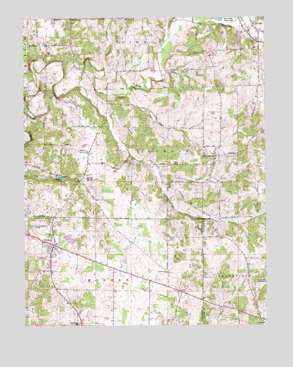
Palmyra, IN USGS Topographic Map
Click on map above to begin viewing in our Map Viewer.

This topographic map contains these locations and features:
Feature Name Type Latitude Longitude GNIS ID View Map
Bear CreekStreamN38.4726°W86.0969°430621View Map
Bethlehem ChurchChurchN38.4320°W86.0491°430978View Map
Big Springs ChurchChurchN38.4848°W86.1139°431067View Map
Crusade SchoolSchoolN38.4120°W86.1114°433228View Map
Dutch CreekStreamN38.4687°W86.0722°433816View Map
Goss CemeteryCemeteryN38.4648°W86.0047°435240View Map
Greenville Water Supply DamDamN38.3926°W86.0008°447203View Map
Hiestand CemeteryCemeteryN38.4612°W86.0259°436128View Map
Jackson Township Fire DepartmentBuildingN38.4407°W86.0272°2626274View Map
Little Bear CreekStreamN38.4376°W86.0553°437987View Map
MartinsburgPopulated PlaceN38.4440°W86.0261°438682View Map
Martinsburg CemeteryCemeteryN38.4437°W86.0211°438683View Map
Morgan Elementary SchoolSchoolN38.3759°W86.0989°447042View Map
Mount Washington ChurchChurchN38.4859°W86.0308°439723View Map
Old PekinPopulated PlaceN38.4973°W86.0033°449044View Map
PalmyraPopulated PlaceN38.4078°W86.1100°440849View Map
Palmyra CemeteryCemeteryN38.4028°W86.1155°440850View Map
Palmyra Fire DepartmentBuildingN38.4084°W86.1124°2701388View Map
Palmyra LakeLakeN38.4357°W86.1066°440851View Map
Palmyra Volunteer Fire DepartmentBuildingN38.4084°W86.1124°2626204View Map
Punch RunStreamN38.4789°W86.0833°441645View Map
Rickerd CemeteryCemeteryN38.4642°W86.0994°441982View Map
Shorts CornerPopulated PlaceN38.4998°W86.1003°443457View Map
Snyders ChapelChurchN38.3970°W86.0516°443750View Map
South Liberty ChurchChurchN38.4453°W86.0922°443828View Map
Town of PalmyraCivilN38.4081°W86.1086°2396845View Map
Township of JacksonCivilN38.4450°W86.0582°453472View Map
Township of MorganCivilN38.3751°W86.0874°453653View Map
Vincennes TrailTrailN38.4420°W86.0594°445302View Map
Voyles CemeteryCemeteryN38.4712°W86.1247°445323View Map

Note: Coordinates in the location and feature list above are referenced to NAD83 datum.


Copyright (C) 2008-2024 Ryan Niemi / Sunset Dynamics ... All Rights Reserved