TopoQuest Logo
Do you find TopoQuest useful?
Help keep TopoQuest running and adding new maps/features by donating!
Bitcoin:  19c7KJd3qBynnjoSw5npx9KScwjBe4ifkT
Litecoin:  LXs6TkuXGGXo1vDsWCkWVdjQX94eUKd6ui
Home View Maps Find Maps Find Places Resources & Links


Pandale, Texas Topographic Map

USGS Map Title: Pandale, TX
USGS Map MRC: 30101B5
DRG (GeoTIFF) Download: o30101b5.tif


Neighboring USGS Topographic Map Quads:


  Post Canyon, TX  
30101C6
 

  Antone Canyon, TX  
30101C5
 

  Howards Well SW, TX  
30101C4
 

  Hackberry Crossing, TX  
30101B6
 

  Pandale, TX  
30101B5
 

  Divide Well Draw, TX  
30101B4
 

  Roundhill Ranch, TX  
30101A6
 

  Little Fielder Draw, TX  
30101A5
 

  Everett Canyon, TX  
30101A4


Map MRC Location:

N31°
W102°
N31°
W101°
H8 H7 H6 H5 H4 H3 H2 H1
G8 G7 G6 G5 G4 G3 G2 G1
F8 F7 F6 F5 F4 F3 F2 F1
E8 E7 E6 E5 E4 E3 E2 E1
D8 D7 D6 D5 D4 D3 D2 D1
C8 C7 C6 C5 C4 C3 C2 C1
B8 B7 B6 B5 B4 B3 B2 B1
A8 A7 A6 A5 A4 A3 A2 A1
N30°
W102°
N30°
W101°

Pandale, TX USGS 1:24K Topographic Map Preview:
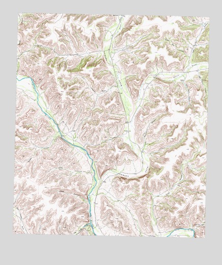
Pandale, TX USGS Topographic Map
Click on map above to begin viewing in our Map Viewer.

This topographic map contains these locations and features:
Feature Name Type Latitude Longitude GNIS ID View Map
Arledge RanchLocaleN30.2141°W101.5162°1329674View Map
Big Fielder DrawValleyN30.1319°W101.5751°1330594View Map
Brushy CanyonValleyN30.1832°W101.5973°1331415View Map
Bunger RanchLocaleN30.2496°W101.5587°1331652View Map
Cash CanyonValleyN30.1438°W101.5771°1332287View Map
Davis CanyonValleyN30.1607°W101.5740°1334082View Map
Devils DrawValleyN30.1995°W101.5479°1334298View Map
Everett RanchLocaleN30.1255°W101.5365°1335566View Map
Howard DrawValleyN30.1536°W101.5719°1374165View Map
Howard SpringsSpringN30.1585°W101.5421°1998240View Map
John Davis CanyonValleyN30.2170°W101.5174°1338755View Map
Kid CanyonValleyN30.2099°W101.5595°1339088View Map
Mills RanchLocaleN30.2069°W101.5660°1341690View Map
New Well CanyonValleyN30.2215°W101.5129°1342523View Map
PandalePopulated PlaceN30.1844°W101.5510°1378828View Map
Perkins DrawValleyN30.2421°W101.5586°1343858View Map
Slick Rock CanyonValleyN30.2271°W101.5123°1347233View Map
Spring CanyonValleyN30.1297°W101.5083°1347698View Map
Tardy CanyonValleyN30.1252°W101.5276°1348246View Map
Two Section CanyonValleyN30.1733°W101.5428°1348983View Map
Will Davis CanyonValleyN30.2184°W101.5068°1350103View Map

Note: Coordinates in the location and feature list above are referenced to NAD83 datum.


Copyright (C) 2008-2025 Ryan Niemi / Sunset Dynamics ... All Rights Reserved