TopoQuest Logo
Do you find TopoQuest useful?
Help keep TopoQuest running and adding new maps/features by donating!
Bitcoin:  19c7KJd3qBynnjoSw5npx9KScwjBe4ifkT
Litecoin:  LXs6TkuXGGXo1vDsWCkWVdjQX94eUKd6ui
Home View Maps Find Maps Find Places Resources & Links


Pando, Colorado Topographic Map

USGS Map Title: Pando, CO
USGS Map MRC: 39106D3
DRG (GeoTIFF) Download: o39106d3.tif


Neighboring USGS Topographic Map Quads:


  Minturn, CO  
39106E4
 

  Red Cliff, CO  
39106E3
 

  Vail Pass, CO  
39106E2
 

  Mount of the Holy Cross, CO  
39106D4
 

  Pando, CO  
39106D3
 

  Copper Mountain, CO  
39106D2
 

  Homestake Reservoir, CO  
39106C4
 

  Leadville North, CO  
39106C3
 

  Climax, CO  
39106C2


Map MRC Location:

N40°
W107°
N40°
W106°
H8 H7 H6 H5 H4 H3 H2 H1
G8 G7 G6 G5 G4 G3 G2 G1
F8 F7 F6 F5 F4 F3 F2 F1
E8 E7 E6 E5 E4 E3 E2 E1
D8 D7 D6 D5 D4 D3 D2 D1
C8 C7 C6 C5 C4 C3 C2 C1
B8 B7 B6 B5 B4 B3 B2 B1
A8 A7 A6 A5 A4 A3 A2 A1
N39°
W107°
N39°
W106°

Pando, CO USGS 1:24K Topographic Map Preview:
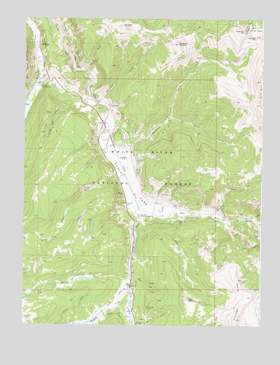
Pando, CO USGS Topographic Map
Click on map above to begin viewing in our Map Viewer.

This topographic map contains these locations and features:
Feature Name Type Latitude Longitude GNIS ID View Map
Bennet GulchValleyN39.3930°W106.3207°179517View Map
Blodgett CampgroundLocaleN39.4719°W106.3667°179545View Map
Camp HaleLocaleN39.4430°W106.3228°179555View Map
Camp Hole Recreation AreaLocaleN39.4428°W106.3220°197222View Map
Cataract CreekStreamN39.4203°W106.2836°179568View Map
Eagle ParkFlatN39.4286°W106.3161°179556View Map
East Fork Eagle RiverStreamN39.4217°W106.3134°179570View Map
El Capitan MineMineN39.3825°W106.3097°179561View Map
Fiddler CreekStreamN39.3942°W106.3178°179559View Map
Homestake CampgroundLocaleN39.4953°W106.3695°179542View Map
Hornsilver CampgroundLocaleN39.4889°W106.3678°179543View Map
Hornsilver MountainSummitN39.4969°W106.3250°179548View Map
Jones GulchValleyN39.4193°W106.2943°179562View Map
McAllister GulchValleyN39.4662°W106.3355°179549View Map
Mill CreekStreamN39.3914°W106.3728°175931View Map
MitchellPopulated PlaceN39.3917°W106.3192°179560View Map
Mitchell CreekStreamN39.3908°W106.3200°179564View Map
No Name GulchValleyN39.4659°W106.3493°179546View Map
PandoPopulated PlaceN39.4572°W106.3336°179547View Map
Pearl CreekStreamN39.4597°W106.2986°179554View Map
Piney GulchValleyN39.3909°W106.3200°179566View Map
Ptarmigan HillSummitN39.4950°W106.2595°179551View Map
Ptarmigan PassGapN39.4930°W106.2534°179552View Map
Ranch CreekStreamN39.4200°W106.3070°179557View Map
Resolution CreekStreamN39.4480°W106.3278°179553View Map
Resolution MountainSummitN39.4925°W106.2945°179550View Map
Rule GulchValleyN39.4222°W106.3201°179558View Map
Sheep GulchValleyN39.4176°W106.2592°179569View Map
Silver GulchValleyN39.4789°W106.3434°179544View Map
South Fork Eagle RiverStreamN39.4217°W106.3134°179567View Map
Taylor HillSummitN39.3855°W106.2886°179563View Map
Wurts DitchCanalN39.4214°W106.3428°202666View Map
Yoder GulchValleyN39.4372°W106.3256°179541View Map

Note: Coordinates in the location and feature list above are referenced to NAD83 datum.


Copyright (C) 2008-2025 Ryan Niemi / Sunset Dynamics ... All Rights Reserved