TopoQuest Logo
Do you find TopoQuest useful?
Help keep TopoQuest running and adding new maps/features by donating!
Bitcoin:  19c7KJd3qBynnjoSw5npx9KScwjBe4ifkT
Litecoin:  LXs6TkuXGGXo1vDsWCkWVdjQX94eUKd6ui
Home View Maps Find Maps Find Places Resources & Links


Passapatanzy, Virginia Topographic Map

USGS Map Title: Passapatanzy, VA
USGS Map MRC: 38077C3
DRG (GeoTIFF) Download: o38077c3.tif


Neighboring USGS Topographic Map Quads:


  Stafford, VA  
38077D4
 

  Widewater, VA  
38077D3
 

  Nanjemoy, MD  
38077D2
 

  Fredericksburg, VA  
38077C4
 

  Passapatanzy, VA  
38077C3
 

  King George, VA  
38077C2
 

  Guinea, VA  
38077B4
 

  Rappahannock Academy, VA  
38077B3
 

  Port Royal, VA  
38077B2


Map MRC Location:

N39°
W78°
N39°
W77°
H8 H7 H6 H5 H4 H3 H2 H1
G8 G7 G6 G5 G4 G3 G2 G1
F8 F7 F6 F5 F4 F3 F2 F1
E8 E7 E6 E5 E4 E3 E2 E1
D8 D7 D6 D5 D4 D3 D2 D1
C8 C7 C6 C5 C4 C3 C2 C1
B8 B7 B6 B5 B4 B3 B2 B1
A8 A7 A6 A5 A4 A3 A2 A1
N38°
W78°
N38°
W77°

Passapatanzy, VA USGS 1:24K Topographic Map Preview:
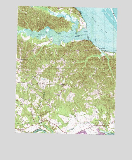
Passapatanzy, VA USGS Topographic Map
Click on map above to begin viewing in our Map Viewer.

This topographic map contains these locations and features:
Feature Name Type Latitude Longitude GNIS ID View Map
Accokeek CreekStreamN38.3501°W77.3050°1462350View Map
Battery Ridge EstatesPopulated PlaceN38.3144°W77.3538°2458876View Map
Beaverdam RunStreamN38.3390°W77.3297°1462968View Map
Belle Harbor Yacht ClubLocaleN38.3423°W77.3302°2458534View Map
Belle PlainsLocaleN38.3423°W77.3308°1463045View Map
Belvedere BeachPopulated PlaceN38.3351°W77.2711°1496799View Map
Bethel Baptist Church CemeteryCemeteryN38.2995°W77.3578°1749079View Map
Bethel ChurchChurchN38.2990°W77.3580°1463200View Map
Bethlehem CemeteryCemeteryN38.2936°W77.3568°1749080View Map
Bethlehem ChurchChurchN38.2940°W77.3578°1463243View Map
Big MarshSwampN38.3449°W77.3414°1463381View Map
Birchwood RunStreamN38.2510°W77.2578°1463450View Map
BiscoePopulated PlaceN38.3560°W77.2893°2458891View Map
Black SwampSwampN38.3374°W77.3229°1463511View Map
Black Swamp BranchStreamN38.3385°W77.3211°1463512View Map
Boykins IslandIslandN38.3487°W77.3233°1463735View Map
Bull BluffCliffN38.3426°W77.2844°1464058View Map
Butzner CornerPopulated PlaceN38.2557°W77.3575°1496824View Map
Chapel HeightsPopulated PlaceN38.2851°W77.3513°2458932View Map
Colbert Walker EstatesPopulated PlaceN38.2960°W77.3547°2458952View Map
Cox CornerPopulated PlaceN38.2987°W77.3594°1496859View Map
Crows Nest HarborPopulated PlaceN38.3671°W77.3682°2458968View Map
Crows Nest PointCapeN38.3523°W77.3064°1465492View Map
DartmoorPopulated PlaceN38.3620°W77.2917°2458970View Map
Dirt Bridge RunStreamN38.3304°W77.2661°1465817View Map
Fines CornerPopulated PlaceN38.3221°W77.3686°1496895View Map
Fletchers ChapelChurchN38.2968°W77.3150°1466711View Map
Fletchers Chapel CemeteryCemeteryN38.2974°W77.3153°1749180View Map
FoxberryPopulated PlaceN38.3187°W77.3580°2459005View Map
GaylesPopulated PlaceN38.2971°W77.3147°1749181View Map
GobyPopulated PlaceN38.3137°W77.2741°1496925View Map
Graves CornerPopulated PlaceN38.2568°W77.2811°1496927View Map
Howes BluffPopulated PlaceN38.3007°W77.3657°2459059View Map
IgoLocaleN38.2893°W77.2705°1468447View Map
Indian PointCapeN38.3498°W77.3014°1468480View Map
James Madison DistrictCivilN38.2645°W77.2594°1927355View Map
JapazawsPopulated PlaceN38.3354°W77.3306°2459070View Map
Johnsons CornerPopulated PlaceN38.2768°W77.3308°1496956View Map
Knotsmythes LandingPopulated PlaceN38.3314°W77.3720°2459085View Map
Lambs CreekPopulated PlaceN38.2637°W77.2691°1496975View Map
Lambs CreekStreamN38.2510°W77.2580°1469113View Map
Lambs Creek ChurchChurchN38.2643°W77.2689°1749190View Map
Lambs Creek School (historical)SchoolN38.2765°W77.2755°1749191View Map
Lyons DenPopulated PlaceN38.3718°W77.3134°2459104View Map
MarlboroPopulated PlaceN38.3601°W77.2987°2459115View Map
Marlboro PointCapeN38.3515°W77.2875°1470100View Map
Marlborough NeckCapeN38.3585°W77.3247°1749125View Map
Marshall WoodsPopulated PlaceN38.3226°W77.3344°2459118View Map
Montague LandingPopulated PlaceN38.3674°W77.3086°2459133View Map
Mount Moriah Church (historical)ChurchN38.2915°W77.2655°1749199View Map
Mountain View ChurchChurchN38.3215°W77.3147°1471200View Map
MustoePopulated PlaceN38.3087°W77.2797°1497032View Map
Oakland CemeteryCemeteryN38.2876°W77.3205°1471775View Map
Old Landing PointCapeN38.3454°W77.3303°1471850View Map
PassapatanzyPopulated PlaceN38.2973°W77.3141°1497075View Map
Passapatanzy Census Designated PlaceCensusN38.2942°W77.3266°2629843View Map
Passapatanzy CreekStreamN38.3337°W77.2686°1472095View Map
Popcastle CreekStreamN38.2593°W77.2605°1472623View Map
Potomac CreekStreamN38.3473°W77.2864°1472708View Map
Potomac Creek EstatesPopulated PlaceN38.3399°W77.3582°2459177View Map
Potomac KnollsPopulated PlaceN38.3660°W77.2956°2459179View Map
Potomac OverlookPopulated PlaceN38.3699°W77.2995°2459180View Map
River BendPopulated PlaceN38.2548°W77.3470°2459197View Map
Sandy RidgePopulated PlaceN38.3062°W77.3593°2459215View Map
SealstonPopulated PlaceN38.2615°W77.3319°1497131View Map
Sealston Elementary SchoolSchoolN38.2649°W77.3337°2465282View Map
Sealston Post OfficePost OfficeN38.2602°W77.3299°2766498View Map
Sealston Station (historical)LocaleN38.2715°W77.3286°1749214View Map
Shea EstatesPopulated PlaceN38.3304°W77.3343°2459227View Map
Spillmans LandingLocaleN38.3451°W77.3511°1497158View Map
Stafford County Fire Department Station 7 White OakBuildingN38.3020°W77.3747°2331641View Map
Stone PointCapeN38.3465°W77.3591°1475183View Map
Sycamore RidgePopulated PlaceN38.3066°W77.3661°2459272View Map
Taylors DamDamN38.2535°W77.2997°1490188View Map
Taylors PondReservoirN38.2535°W77.2997°1490189View Map
The Holly WoodsPopulated PlaceN38.2642°W77.3552°2459282View Map
Union Belle Baptist Church CemeteryCemeteryN38.2774°W77.3669°1749164View Map
Union Belle ChurchChurchN38.2774°W77.3666°1476020View Map
Waugh PointCapeN38.3437°W77.3036°1472763View Map
Waugh Point MarinaHarborN38.3423°W77.3052°2520123View Map
Whipsawason Club HouseBuildingN38.3298°W77.3114°1749222View Map
Whipsawasons PointCapeN38.3423°W77.3175°1476568View Map
WhitakerPopulated PlaceN38.3043°W77.3634°2459312View Map
White Oak RunStreamN38.2612°W77.3455°1476618View Map
Willamsburg on the PotomacPopulated PlaceN38.3748°W77.3092°2459320View Map
Woodlanding VillagePopulated PlaceN38.3168°W77.3390°2459331View Map
Yendor LandingPopulated PlaceN38.3287°W77.3519°2459338View Map

Note: Coordinates in the location and feature list above are referenced to NAD83 datum.


Copyright (C) 2008-2024 Ryan Niemi / Sunset Dynamics ... All Rights Reserved