TopoQuest Logo
Do you find TopoQuest useful?
Help keep TopoQuest running and adding new maps/features by donating!
Bitcoin:  19c7KJd3qBynnjoSw5npx9KScwjBe4ifkT
Litecoin:  LXs6TkuXGGXo1vDsWCkWVdjQX94eUKd6ui
Home View Maps Find Maps Find Places Resources & Links


Pea Ridge, Arkansas Topographic Map

USGS Map Title: Pea Ridge, AR
USGS Map MRC: 36094D1
DRG (GeoTIFF) Download: o36094d1.tif


Neighboring USGS Topographic Map Quads:


  Powell, MO  
36094E2
 

  Jacket, MO  
36094E1
 

  Seligman, MO  
36093E8
 

  Bentonville North, AR  
36094D2
 

  Pea Ridge, AR  
36094D1
 

  Garfield, AR  
36093D8
 

  Bentonville South, AR  
36094C2
 

  Rogers, AR  
36094C1
 

  War Eagle, AR  
36093C8


Map MRC Location:

N37°
W95°
N37°
W94°
H8 H7 H6 H5 H4 H3 H2 H1
G8 G7 G6 G5 G4 G3 G2 G1
F8 F7 F6 F5 F4 F3 F2 F1
E8 E7 E6 E5 E4 E3 E2 E1
D8 D7 D6 D5 D4 D3 D2 D1
C8 C7 C6 C5 C4 C3 C2 C1
B8 B7 B6 B5 B4 B3 B2 B1
A8 A7 A6 A5 A4 A3 A2 A1
N36°
W95°
N36°
W94°

Pea Ridge, AR USGS 1:24K Topographic Map Preview:
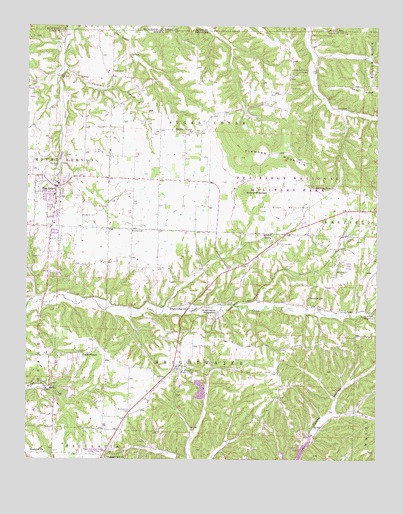
Pea Ridge, AR USGS Topographic Map
Click on map above to begin viewing in our Map Viewer.

This topographic map contains these locations and features:
Feature Name Type Latitude Longitude GNIS ID View Map
AvocaPopulated PlaceN36.4020°W94.0708°45989View Map
Avoca Fire StationBuildingN36.3997°W94.0709°2116104View Map
Avoca Post OfficePost OfficeN36.4045°W94.0714°84522View Map
Banks CemeteryCemeteryN36.4870°W94.0952°46079View Map
BrightwaterPopulated PlaceN36.4179°W94.0569°76418View Map
Brightwater BridgeBridgeN36.4195°W94.0558°75405View Map
Brightwater United Methodist ChurchChurchN36.4187°W94.0671°76419View Map
Buttram CemeteryCemeteryN36.4412°W94.0888°76479View Map
Buttrams Chapel (historical)ChurchN36.4412°W94.0883°75411View Map
Buttrams Chapel School (historical)SchoolN36.4412°W94.0883°75412View Map
Buttry (historical)Populated PlaceN36.4601°W94.0599°75413View Map
Carden BranchStreamN36.4879°W94.1110°47466View Map
City of Pea RidgeCivilN36.4490°W94.1212°2404492View Map
Corinth Community HallLocaleN36.4876°W94.0255°48055View Map
Corinth School (historical)SchoolN36.4873°W94.0252°75448View Map
Dean CemeteryCemeteryN36.4190°W94.0213°76766View Map
Elkhorn MountainSummitN36.4600°W94.0226°76867View Map
Elkhorn TavernPopulated PlaceN36.4537°W94.0158°76868View Map
Ford CemeteryCemeteryN36.4559°W94.0263°49154View Map
Freedom Freewill Baptist ChurchChurchN36.4217°W94.0196°76972View Map
Freedom School (historical)SchoolN36.4195°W94.0194°75518View Map
Hopewell School (historical)SchoolN36.4048°W94.1052°75560View Map
LeetownPopulated PlaceN36.4315°W94.0474°75584View Map
Liberty CemeteryCemeteryN36.4390°W94.0107°51096View Map
Liberty School (historical)SchoolN36.4367°W94.0138°75588View Map
Line Store (historical)Populated PlaceN36.4978°W94.0244°75589View Map
Patterson CemeteryCemeteryN36.4453°W94.1058°53224View Map
Pea RidgePopulated PlaceN36.4540°W94.1152°77964View Map
Pea Ridge Ambulance ServiceBuildingN36.4408°W94.1171°2119210View Map
Pea Ridge BattlefieldLocaleN36.4481°W94.0333°77965View Map
Pea Ridge CemeteryCemeteryN36.4537°W94.1202°75956View Map
Pea Ridge Fire DepartmentBuildingN36.4408°W94.1171°2116944View Map
Pea Ridge High SchoolSchoolN36.4560°W94.1240°75958View Map
Pea Ridge Intermediate SchoolSchoolN36.4549°W94.1132°75957View Map
Pea Ridge Middle SchoolSchoolN36.4540°W94.1233°2038995View Map
Pea Ridge Mill (historical)LocaleN36.4401°W94.0488°75959View Map
Pea Ridge National Military ParkParkN36.4544°W94.0347°53246View Map
Pea Ridge National Military Park Park SecurityBuildingN36.4438°W94.0255°2119017View Map
Pea Ridge Police DepartmentBuildingN36.4408°W94.1170°2119018View Map
Pea Ridge Post OfficePost OfficeN36.4537°W94.1152°84623View Map
Pippin (historical)Populated PlaceN36.4940°W94.0233°75965View Map
Pleasant HillPopulated PlaceN36.3756°W94.1141°75967View Map
Pleasant Hill Baptist ChurchChurchN36.3756°W94.0966°78052View Map
Pleasant Hill School (historical)SchoolN36.3756°W94.1135°75970View Map
Pratt CemeteryCemeteryN36.4376°W94.0338°53779View Map
Rascal Flat School (historical)SchoolN36.3965°W94.0299°75986View Map
Round MountainSummitN36.4526°W94.0478°78221View Map
Saint Vincents CemeteryCemeteryN36.3895°W94.0880°54482View Map
Scott CemeteryCemeteryN36.4823°W94.0316°54643View Map
Snoderley CemeteryCemeteryN36.4173°W94.0013°54983View Map
Town of AvocaCivilN36.3980°W94.0713°2405190View Map
Township of Brightwater (historical)CivilN36.4126°W94.0558°78863View Map
Township of Sugar Creek (historical)CivilN36.4709°W94.0558°69596View Map
Tucks Chapel CemeteryCemeteryN36.4045°W94.1049°76059View Map
Tucks Chapel Methodist ChurchChurchN36.4048°W94.1052°78592View Map
Twelve Corners Baptist ChurchChurchN36.4698°W94.0669°78602View Map
Twelve Corners CemeteryCemeteryN36.4700°W94.0626°76060View Map
Twelve Corners School (historical)SchoolN36.4695°W94.0660°76061View Map
Wesleyan ChurchChurchN36.3767°W94.1185°56160View Map
Williams CemeteryCemeteryN36.4165°W94.0005°56393View Map
Winton SpringSpringN36.4406°W94.0377°78792View Map

Note: Coordinates in the location and feature list above are referenced to NAD83 datum.


Copyright (C) 2008-2025 Ryan Niemi / Sunset Dynamics ... All Rights Reserved