TopoQuest Logo
Do you find TopoQuest useful?
Help keep TopoQuest running and adding new maps/features by donating!
Bitcoin:  19c7KJd3qBynnjoSw5npx9KScwjBe4ifkT
Litecoin:  LXs6TkuXGGXo1vDsWCkWVdjQX94eUKd6ui
Home View Maps Find Maps Find Places Resources & Links


Bernice, Oklahoma Topographic Map

USGS Map Title: Bernice, OK
USGS Map MRC: 36094E8
DRG (GeoTIFF) Download: o36094e8.tif


Neighboring USGS Topographic Map Quads:


  Vinita NE, OK  
36095F1
 

  Afton, OK  
36094F8
 

  Afton NE, OK  
36094F7
 

  Ketchum, OK  
36095E1
 

  Bernice, OK  
36094E8
 

  Grove, OK  
36094E7
 

  Spavinaw, OK  
36095D1
 

  Chloeta, OK  
36094D8
 

  Jay, OK  
36094D7


Map MRC Location:

N37°
W95°
N37°
W94°
H8 H7 H6 H5 H4 H3 H2 H1
G8 G7 G6 G5 G4 G3 G2 G1
F8 F7 F6 F5 F4 F3 F2 F1
E8 E7 E6 E5 E4 E3 E2 E1
D8 D7 D6 D5 D4 D3 D2 D1
C8 C7 C6 C5 C4 C3 C2 C1
B8 B7 B6 B5 B4 B3 B2 B1
A8 A7 A6 A5 A4 A3 A2 A1
N36°
W95°
N36°
W94°

Bernice, OK USGS 1:24K Topographic Map Preview:
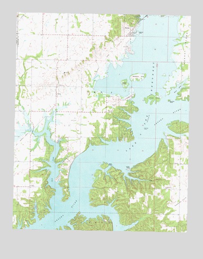
Bernice, OK USGS Topographic Map
Click on map above to begin viewing in our Map Viewer.

This topographic map contains these locations and features:
Feature Name Type Latitude Longitude GNIS ID View Map
BernicePopulated PlaceN36.6159°W94.9177°1090016View Map
Bernice PointCapeN36.6148°W94.9119°1090017View Map
Big HollowValleyN36.5301°W94.9066°1090115View Map
Blackberry IslandIslandN36.5890°W94.9113°1090215View Map
Blue Star IslandIslandN36.5762°W94.8894°1090299View Map
Cherokee Seaplane BaseAirportN36.5834°W94.9169°1102348View Map
City of Bernice Volunteer Fire DepartmentBuildingN36.6212°W94.9187°2656981View Map
CleoraCivilN36.5737°W94.9479°2631090View Map
CleoraPopulated PlaceN36.5790°W94.9711°1100301View Map
Cleora Census Designated PlaceCensusN36.5737°W94.9479°2407633View Map
Cleora Community Fire DepartmentBuildingN36.5753°W94.9712°2656839View Map
Cleora Emergency Medical ServicesBuildingN36.5678°W94.9862°2695922View Map
Cleora Fire Department Station 2BuildingN36.5457°W94.9621°2657499View Map
Cleora Public SchoolSchoolN36.5908°W94.9653°1091454View Map
DennisPopulated PlaceN36.5392°W94.8841°1100349View Map
Duck CreekStreamN36.5140°W94.9680°1092265View Map
Goat IslandIslandN36.5376°W94.9344°1093221View Map
Harbors Inn HeliportAirportN36.5584°W94.9669°1102521View Map
Hiderbrand CemeteryCemeteryN36.5254°W94.8916°1093726View Map
Johnson HollowValleyN36.5342°W94.9341°1094249View Map
Lyon Airport (historical)AirportN36.5229°W94.9605°1763603View Map
McLaughlin CemeteryCemeteryN36.5687°W94.9338°1095264View Map
Monkey IslandIslandN36.6090°W94.8769°1095477View Map
Rabbit IslandIslandN36.5848°W94.9213°1097012View Map
Saddle IslandIslandN36.5359°W94.9175°1097565View Map
Snake IslandIslandN36.5770°W94.9002°1098162View Map
Sweetwater HollowValleyN36.5562°W94.8811°1098696View Map
Town of BerniceCivilN36.6220°W94.9108°2411679View Map
Township 5CivilN36.5834°W94.9169°1824556View Map
Two Tree IslandIslandN36.5598°W94.9072°1099124View Map
Tynon BluffsCliffN36.5398°W94.9580°1099137View Map
Wallen CemeteryCemeteryN36.6059°W94.9188°1099314View Map
West BayBayN36.5823°W94.8836°1099505View Map

Note: Coordinates in the location and feature list above are referenced to NAD83 datum.


Copyright (C) 2008-2024 Ryan Niemi / Sunset Dynamics ... All Rights Reserved