TopoQuest Logo
Do you find TopoQuest useful?
Help keep TopoQuest running and adding new maps/features by donating!
Bitcoin:  19c7KJd3qBynnjoSw5npx9KScwjBe4ifkT
Litecoin:  LXs6TkuXGGXo1vDsWCkWVdjQX94eUKd6ui
Home View Maps Find Maps Find Places Resources & Links


Alamito, New Mexico Topographic Map

USGS Map Title: Alamito, NM
USGS Map MRC: 35104G4
DRG (GeoTIFF) Download: o35104g4.tif


Neighboring USGS Topographic Map Quads:


  Alamosa Creek, NM  
35104H5
 

  Canon Las Cuevas, NM  
35104H4
 

  Beaver Canyon, NM  
35104H3
 

  Canon Ancho, NM  
35104G5
 

  Alamito, NM  
35104G4
 

  Canon Encierro, NM  
35104G3
 

  Maes, NM  
35104F5
 

  Sabinoso, NM  
35104F4
 

  Arroyo Alamocito, NM  
35104F3


Map MRC Location:

N36°
W105°
N36°
W104°
H8 H7 H6 H5 H4 H3 H2 H1
G8 G7 G6 G5 G4 G3 G2 G1
F8 F7 F6 F5 F4 F3 F2 F1
E8 E7 E6 E5 E4 E3 E2 E1
D8 D7 D6 D5 D4 D3 D2 D1
C8 C7 C6 C5 C4 C3 C2 C1
B8 B7 B6 B5 B4 B3 B2 B1
A8 A7 A6 A5 A4 A3 A2 A1
N35°
W105°
N35°
W104°

Alamito, NM USGS 1:24K Topographic Map Preview:
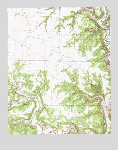
Alamito, NM USGS Topographic Map
Click on map above to begin viewing in our Map Viewer.

This topographic map contains these locations and features:
Feature Name Type Latitude Longitude GNIS ID View Map
AlamitoPopulated PlaceN35.8225°W104.4375°898513View Map
AlamitoLocaleN35.8259°W104.4325°924329View Map
Banco RedondoAreaN35.7923°W104.4700°886035View Map
Caņon AlamitoValleyN35.8664°W104.4183°897782View Map
Caņon de DavidValleyN35.7920°W104.4155°897754View Map
Caņon de LaquestaValleyN35.7717°W104.3811°897758View Map
Caņon Dos NievesValleyN35.7881°W104.3889°898260View Map
Caņon el CapulinValleyN35.8261°W104.3755°897774View Map
Caņon el GachupinValleyN35.7878°W104.3889°897775View Map
Caņon EncierroValleyN35.7575°W104.3783°897804View Map
Caņon HondoValleyN35.7809°W104.3844°897812View Map
Caņon la TinajasValleyN35.7848°W104.4030°897779View Map
Caņon los AlamosValleyN35.7886°W104.4103°897780View Map
Caņon MedinaValleyN35.8620°W104.4539°897828View Map
Caņon OsitoValleyN35.8509°W104.3916°897832View Map
Caņon OsoValleyN35.8536°W104.3850°897833View Map
Carrizo CreekStreamN35.8609°W104.3886°897329View Map
Devils CanyonValleyN35.8734°W104.4055°888347View Map
El OjitoSpringN35.8081°W104.4783°888816View Map
El SierroSummitN35.8081°W104.4603°898653View Map
Las PlacitasAreaN35.7612°W104.4419°890963View Map
Las VentanasAreaN35.7986°W104.4919°890966View Map
LaubhanLocaleN35.8259°W104.4083°924560View Map
Lower Horseshoe BendBendN35.8448°W104.3775°891430View Map
McDanielsLocaleN35.8209°W104.4875°924566View Map
Mensor WindmillLocaleN35.8742°W104.4619°891846View Map
Mexican CanyonValleyN35.8028°W104.4969°891919View Map
Pozo AzulSpringN35.7614°W104.4789°893453View Map
School Section CanyonValleyN35.7923°W104.4903°894632View Map
Tata ViqueStreamN35.7870°W104.4753°895522View Map
West WindmillLocaleN35.8359°W104.4400°896460View Map

Note: Coordinates in the location and feature list above are referenced to NAD83 datum.


Copyright (C) 2008-2025 Ryan Niemi / Sunset Dynamics ... All Rights Reserved