TopoQuest Logo
Do you find TopoQuest useful?
Help keep TopoQuest running and adding new maps/features by donating!
Bitcoin:  19c7KJd3qBynnjoSw5npx9KScwjBe4ifkT
Litecoin:  LXs6TkuXGGXo1vDsWCkWVdjQX94eUKd6ui
Home View Maps Find Maps Find Places Resources & Links


Pigeon Creek, Alabama Topographic Map

USGS Map Title: Pigeon Creek, AL
USGS Map MRC: 31086F5
DRG (GeoTIFF) Download: o31086f5.tif


Neighboring USGS Topographic Map Quads:


  Greenville West, AL  
31086G6
 

  Greenville East, AL  
31086G5
 

  Honoraville, AL  
31086G4
 

  Georgiana East, AL  
31086F6
 

  Pigeon Creek, AL  
31086F5
 

  Moodys Crossroads, AL  
31086F4
 

  McKenzie, AL  
31086E6
 

  Industry, AL  
31086E5
 

  Leon, AL  
31086E4


Map MRC Location:

N32°
W87°
N32°
W86°
H8 H7 H6 H5 H4 H3 H2 H1
G8 G7 G6 G5 G4 G3 G2 G1
F8 F7 F6 F5 F4 F3 F2 F1
E8 E7 E6 E5 E4 E3 E2 E1
D8 D7 D6 D5 D4 D3 D2 D1
C8 C7 C6 C5 C4 C3 C2 C1
B8 B7 B6 B5 B4 B3 B2 B1
A8 A7 A6 A5 A4 A3 A2 A1
N31°
W87°
N31°
W86°

Pigeon Creek, AL USGS 1:24K Topographic Map Preview:
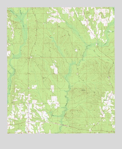
Pigeon Creek, AL USGS Topographic Map
Click on map above to begin viewing in our Map Viewer.

This topographic map contains these locations and features:
Feature Name Type Latitude Longitude GNIS ID View Map
Camp Stanley (historical)LocaleN31.7099°W86.5194°134996View Map
Center Hill School (historical)SchoolN31.6371°W86.5175°154086View Map
Deep Step CreekStreamN31.6999°W86.6180°117193View Map
Ebenezer CemeteryCemeteryN31.6610°W86.5064°117812View Map
F I W Volunteer Fire DepartmentBuildingN31.6364°W86.6037°2691539View Map
Friendship ChurchChurchN31.6549°W86.6002°118666View Map
Friendship ChurchChurchN31.6554°W86.6175°118668View Map
Friendship School (historical)SchoolN31.6535°W86.6002°135011View Map
Halso MillPopulated PlaceN31.7132°W86.5205°156447View Map
Hard Labor CreekStreamN31.7093°W86.5322°119708View Map
Harrigan CreekStreamN31.7254°W86.5097°119785View Map
Hawkins CreekStreamN31.7388°W86.6100°119872View Map
Macedonia ChurchChurchN31.6890°W86.5047°135025View Map
Mercers Bridge (historical)BridgeN31.7127°W86.5097°135028View Map
Mount Carmel CemeteryCemeteryN31.7363°W86.5319°135774View Map
Mount Carmel ChurchChurchN31.7365°W86.5325°123170View Map
Mount Olive East CemeteryCemeteryN31.7004°W86.5969°135778View Map
Mount Olive East ChurchChurchN31.7013°W86.5972°123331View Map
Mount Pleasant Baptist ChurchChurchN31.6454°W86.5994°152490View Map
Mount Pleasant CemeteryCemeteryN31.6454°W86.6044°135032View Map
New Prospect CemeteryCemeteryN31.6796°W86.5833°135782View Map
New Prospect ChurchChurchN31.6799°W86.5839°123883View Map
Pigeon CreekPopulated PlaceN31.6577°W86.5072°156883View Map
Pigeon Creek Lookout TowerTowerN31.6679°W86.5391°164397View Map
SardisPopulated PlaceN31.6799°W86.5066°135789View Map
Sardis Baptist ChurchChurchN31.6804°W86.5069°153334View Map
Sardis CemeteryCemeteryN31.6804°W86.5064°135790View Map
Shiloh CemeteryCemeteryN31.6629°W86.5002°126718View Map
Sims School (historical)SchoolN31.7007°W86.5739°135059View Map
Spring Hill ChurchChurchN31.7349°W86.5800°127252View Map
The Church of the Lord JesusChurchN31.6371°W86.5950°135063View Map

Note: Coordinates in the location and feature list above are referenced to NAD83 datum.


Copyright (C) 2008-2024 Ryan Niemi / Sunset Dynamics ... All Rights Reserved