TopoQuest Logo
Do you find TopoQuest useful?
Help keep TopoQuest running and adding new maps/features by donating!
Bitcoin:  19c7KJd3qBynnjoSw5npx9KScwjBe4ifkT
Litecoin:  LXs6TkuXGGXo1vDsWCkWVdjQX94eUKd6ui
Home View Maps Find Maps Find Places Resources & Links


Pilsen, Kansas Topographic Map

USGS Map Title: Pilsen, KS
USGS Map MRC: 38097D1
DRG (GeoTIFF) Download: o38097d1.tif


Neighboring USGS Topographic Map Quads:


  Tampa, KS  
38097E2
 

  Ramona, KS  
38097E1
 

  Lost Springs, KS  
38096E8
 

  Durham, KS  
38097D2
 

  Pilsen, KS  
38097D1
 

  Lincolnville, KS  
38096D8
 

  Hillsboro, KS  
38097C2
 

  Marion, KS  
38097C1
 

  Lincolnville SW, KS  
38096C8


Map MRC Location:

N39°
W98°
N39°
W97°
H8 H7 H6 H5 H4 H3 H2 H1
G8 G7 G6 G5 G4 G3 G2 G1
F8 F7 F6 F5 F4 F3 F2 F1
E8 E7 E6 E5 E4 E3 E2 E1
D8 D7 D6 D5 D4 D3 D2 D1
C8 C7 C6 C5 C4 C3 C2 C1
B8 B7 B6 B5 B4 B3 B2 B1
A8 A7 A6 A5 A4 A3 A2 A1
N38°
W98°
N38°
W97°

Pilsen, KS USGS 1:24K Topographic Map Preview:
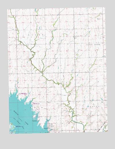
Pilsen, KS USGS Topographic Map
Click on map above to begin viewing in our Map Viewer.

This topographic map contains these locations and features:
Feature Name Type Latitude Longitude GNIS ID View Map
Beauty of the West School (historical)SchoolN38.4495°W97.0220°482926View Map
Belton School (historical)SchoolN38.4933°W97.1147°482929View Map
Clark School (historical)SchoolN38.4492°W97.0953°482939View Map
Cottonwood Point Public Use AreaParkN38.3889°W97.0892°477244View Map
Cross School (historical)SchoolN38.4864°W97.0036°482946View Map
Dobbs School (historical)SchoolN38.3775°W97.0775°482948View Map
EastshorePopulated PlaceN38.3820°W97.0739°484811View Map
Hutchins School (historical)SchoolN38.4933°W97.0772°482972View Map
Kreutziger School (historical)SchoolN38.4206°W97.1045°482975View Map
Marion Cove Public Use AreaParkN38.3806°W97.0756°477242View Map
Mud CreekLocaleN38.4403°W97.0731°482357View Map
PilsenPopulated PlaceN38.4714°W97.0403°477246View Map
Pilsen CemeteryCemeteryN38.4708°W97.0366°2673309View Map
Strassburg Baptist ChurchChurchN38.3992°W97.0775°482740View Map
Strassburg CemeteryCemeteryN38.4059°W97.0769°477243View Map
Township of ClarkCivilN38.4786°W97.0958°477130View Map
Township of GaleCivilN38.3933°W97.0982°477230View Map
Wren School (historical)SchoolN38.4064°W97.0397°483023View Map

Note: Coordinates in the location and feature list above are referenced to NAD83 datum.


Copyright (C) 2008-2025 Ryan Niemi / Sunset Dynamics ... All Rights Reserved