TopoQuest Logo
Do you find TopoQuest useful?
Help keep TopoQuest running and adding new maps/features by donating!
Bitcoin:  19c7KJd3qBynnjoSw5npx9KScwjBe4ifkT
Litecoin:  LXs6TkuXGGXo1vDsWCkWVdjQX94eUKd6ui
Home View Maps Find Maps Find Places Resources & Links


Pine Grove Spring, Nevada Topographic Map

USGS Map Title: Pine Grove Spring, NV
USGS Map MRC: 38119F1
DRG (GeoTIFF) Download: o38119f1.tif


Neighboring USGS Topographic Map Quads:


  Wilson Canyon, NV  
38119G2
 

  Yerington SE, NV  
38119G1
 

  Buck Brush Spring, NV  
38118G8
 

  Mount Etna, NV  
38119F2
 

  Pine Grove Spring, NV  
38119F1
 

  Butler Mountain, NV  
38118F8
 

  Nye Canyon, NV  
38119E2
 

  Wichman Canyon, NV  
38119E1
 

  Mitchell Spring, NV  
38118E8


Map MRC Location:

N39°
W120°
N39°
W119°
H8 H7 H6 H5 H4 H3 H2 H1
G8 G7 G6 G5 G4 G3 G2 G1
F8 F7 F6 F5 F4 F3 F2 F1
E8 E7 E6 E5 E4 E3 E2 E1
D8 D7 D6 D5 D4 D3 D2 D1
C8 C7 C6 C5 C4 C3 C2 C1
B8 B7 B6 B5 B4 B3 B2 B1
A8 A7 A6 A5 A4 A3 A2 A1
N38°
W120°
N38°
W119°

Pine Grove Spring, NV USGS 1:24K Topographic Map Preview:
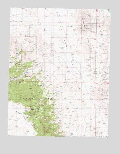
Pine Grove Spring, NV USGS Topographic Map
Click on map above to begin viewing in our Map Viewer.

This topographic map contains these locations and features:
Feature Name Type Latitude Longitude GNIS ID View Map
Cambridge (historical)Populated PlaceN38.6882°W119.0140°848125View Map
Cambridge MineMineN38.6860°W119.0057°859132View Map
Cambridge Post OfficePost OfficeN38.6882°W119.0140°864583View Map
Pine GrovePopulated PlaceN38.6782°W119.1240°860956View Map
Pine Grove CanyonValleyN38.7085°W119.0824°860957View Map
Pine Grove Drift Fence and Cattle GuardLocaleN38.7444°W119.0732°847870View Map
Pine Grove FlatFlatN38.7385°W119.0682°860958View Map
Pine Grove Post Office (historical)Post OfficeN38.6782°W119.1240°864885View Map
Pine Grove SpringSpringN38.6866°W119.1068°860960View Map
RocklandLocaleN38.6521°W119.0943°861154View Map
Rockland CanyonValleyN38.6763°W119.0801°861155View Map
Rockland Mine Post Office (historical)Post OfficeN38.6463°W119.0946°864886View Map
Rockland MinesMineN38.6494°W119.0949°861156View Map
Rockland Post Office (historical)Post OfficeN38.6521°W119.0943°864887View Map
Scotts CanyonValleyN38.7332°W119.0999°861292View Map
Scotts SpringSpringN38.7060°W119.1171°861293View Map
SugarloafSummitN38.6832°W119.1038°861618View Map
Twin SpringsSpringN38.6657°W119.0746°861812View Map
Webster Summit Drift FenceLocaleN38.6832°W119.0215°847872View Map
Webster Summit SpringSpringN38.6624°W119.0688°847874View Map
Webster Water HoleSpringN38.6760°W119.0507°847873View Map
Wheeler Flat DamDamN38.7021°W119.0468°847871View Map
Wheeler MineMineN38.6777°W119.1168°861954View Map
Wilson MinesMineN38.6799°W119.1215°862071View Map

Note: Coordinates in the location and feature list above are referenced to NAD83 datum.


Copyright (C) 2008-2024 Ryan Niemi / Sunset Dynamics ... All Rights Reserved