TopoQuest Logo
Do you find TopoQuest useful?
Help keep TopoQuest running and adding new maps/features by donating!
Bitcoin:  19c7KJd3qBynnjoSw5npx9KScwjBe4ifkT
Litecoin:  LXs6TkuXGGXo1vDsWCkWVdjQX94eUKd6ui
Home View Maps Find Maps Find Places Resources & Links


Pinebluff, North Carolina Topographic Map

USGS Map Title: Pinebluff, NC
USGS Map MRC: 35079A4
DRG (GeoTIFF) Download: o35079a4.tif


Neighboring USGS Topographic Map Quads:


  West End, NC  
35079B5
 

  Southern Pines, NC  
35079B4
 

  Niagara, NC  
35079B3
 

  Hoffman, NC  
35079A5
 

  Pinebluff, NC  
35079A4
 

  McCain, NC  
35079A3
 

  Marston, NC  
34079H5
 

  Silver Hill, NC  
34079H4
 

  Wagram, NC  
34079H3


Map MRC Location:

N36°
W80°
N36°
W79°
H8 H7 H6 H5 H4 H3 H2 H1
G8 G7 G6 G5 G4 G3 G2 G1
F8 F7 F6 F5 F4 F3 F2 F1
E8 E7 E6 E5 E4 E3 E2 E1
D8 D7 D6 D5 D4 D3 D2 D1
C8 C7 C6 C5 C4 C3 C2 C1
B8 B7 B6 B5 B4 B3 B2 B1
A8 A7 A6 A5 A4 A3 A2 A1
N35°
W80°
N35°
W79°

Pinebluff, NC USGS 1:24K Topographic Map Preview:
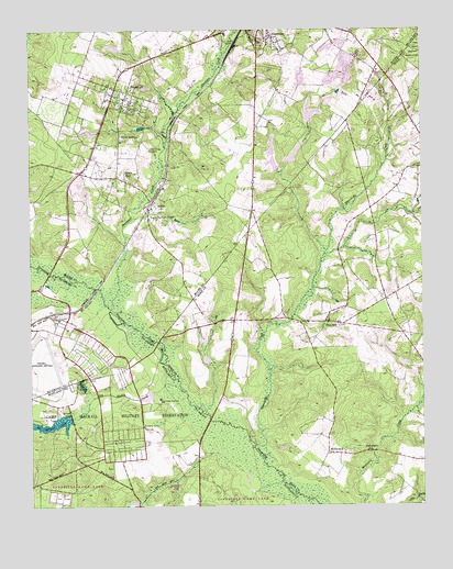
Pinebluff, NC USGS Topographic Map
Click on map above to begin viewing in our Map Viewer.

This topographic map contains these locations and features:
Feature Name Type Latitude Longitude GNIS ID View Map
Aberdeen CreekStreamN35.0521°W79.4742°1018758View Map
Aberdeen Elementary SchoolSchoolN35.1240°W79.4270°1006731View Map
AddorPopulated PlaceN35.0779°W79.4620°1018773View Map
Beaver Dam CreekStreamN35.0149°W79.4420°980811View Map
Big Muddy CreekStreamN35.0304°W79.4523°981427View Map
Big Muddy LakeReservoirN35.0219°W79.4925°981428View Map
Big Muddy Lake DamDamN35.0218°W79.4881°998312View Map
Camp MackallMilitaryN35.0290°W79.4833°2099601View Map
Crestline Volunteer Fire DepartmentBuildingN35.1161°W79.3875°2639317View Map
Hoke County Rescue Squad SubstationBuildingN35.0548°W79.3862°2639630View Map
Holly Hills PondReservoirN35.0777°W79.4823°998364View Map
Holly Hills Pond DamDamN35.0785°W79.4814°998363View Map
Lincoln ParkPopulated PlaceN35.0865°W79.4720°988497View Map
Little Muddy CreekStreamN35.0065°W79.4203°988716View Map
Little Muddy LakeReservoirN35.0302°W79.4581°998319View Map
McFarlandPopulated PlaceN35.0140°W79.4056°989571View Map
McFarland SchoolSchoolN35.0146°W79.3928°989573View Map
Moss Gill LakeReservoirN35.0319°W79.4834°990290View Map
NC Noname Thirty-Eight DamDamN35.0302°W79.4581°998320View Map
Pine Bluff SanatoriumHospitalN35.1035°W79.4723°1024216View Map
Pine HillPopulated PlaceN35.0485°W79.4061°1021906View Map
PinebluffPopulated PlaceN35.1099°W79.4723°1021932View Map
Pinebluff Fire DepartmentBuildingN35.1095°W79.4748°2638735View Map
Pinebluff Post OfficePost OfficeN35.1092°W79.4721°2773781View Map
Pinehill Fire DepartmentBuildingN35.0548°W79.3862°2639632View Map
Poplar Springs ChurchChurchN35.0757°W79.4617°992703View Map
Quewhiffle CreekStreamN35.0163°W79.4287°992950View Map
Silver SpringsPopulated PlaceN35.0963°W79.4711°994822View Map
Silver Springs CemeteryCemeteryN35.0938°W79.4620°994823View Map
Town of PinebluffCivilN35.1088°W79.4713°2407121View Map
Township 8-SandhillsCivilN35.1194°W79.4848°1026974View Map
W C Steinback DamDamN35.0902°W79.4214°998377View Map
WANC-AM (Aberdeen)TowerN35.1224°W79.4156°1018398View Map

Note: Coordinates in the location and feature list above are referenced to NAD83 datum.


Copyright (C) 2008-2025 Ryan Niemi / Sunset Dynamics ... All Rights Reserved