TopoQuest Logo
Do you find TopoQuest useful?
Help keep TopoQuest running and adding new maps/features by donating!
Bitcoin:  19c7KJd3qBynnjoSw5npx9KScwjBe4ifkT
Litecoin:  LXs6TkuXGGXo1vDsWCkWVdjQX94eUKd6ui
Home View Maps Find Maps Find Places Resources & Links


Pinewood, South Carolina Topographic Map

USGS Map Title: Pinewood, SC
USGS Map MRC: 33080F4
DRG (GeoTIFF) Download: o33080f4.tif


Neighboring USGS Topographic Map Quads:


  Poinsett State Park, SC  
33080G5
 

  Privateer, SC  
33080G4
 

  Brogdon, SC  
33080G3
 

  Lone Star, SC  
33080F5
 

  Pinewood, SC  
33080F4
 

  Paxville, SC  
33080F3
 

  Elloree, SC  
33080E5
 

  Saint Paul, SC  
33080E4
 

  Summerton, SC  
33080E3


Map MRC Location:

N34°
W81°
N34°
W80°
H8 H7 H6 H5 H4 H3 H2 H1
G8 G7 G6 G5 G4 G3 G2 G1
F8 F7 F6 F5 F4 F3 F2 F1
E8 E7 E6 E5 E4 E3 E2 E1
D8 D7 D6 D5 D4 D3 D2 D1
C8 C7 C6 C5 C4 C3 C2 C1
B8 B7 B6 B5 B4 B3 B2 B1
A8 A7 A6 A5 A4 A3 A2 A1
N33°
W81°
N33°
W80°

Pinewood, SC USGS 1:24K Topographic Map Preview:
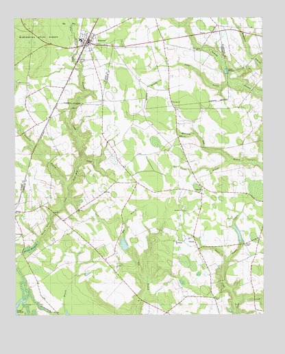
Pinewood, SC USGS Topographic Map
Click on map above to begin viewing in our Map Viewer.

This topographic map contains these locations and features:
Feature Name Type Latitude Longitude GNIS ID View Map
Andrews ChapelChurchN33.6543°W80.3843°1244885View Map
Antioch ChurchChurchN33.6685°W80.4993°1251781View Map
Bacon Hill Church (historical)ChurchN33.7140°W80.4659°1244448View Map
Bacon Hill School (historical)SchoolN33.7143°W80.4656°1244449View Map
Ballard CreekStreamN33.6904°W80.4670°1220309View Map
Belser CreekStreamN33.6288°W80.3890°1220491View Map
Big New Hope ChurchChurchN33.7118°W80.4187°1235886View Map
Brown CemeteryCemeteryN33.6318°W80.3992°1235894View Map
Brown Chapel Union Methodist Episcopal ChurchChurchN33.7079°W80.4837°1244472View Map
Calvary CemeteryCemeteryN33.7004°W80.4170°1235897View Map
Calvary ChurchChurchN33.7004°W80.4173°1247098View Map
Calvary ChurchChurchN33.7371°W80.4092°1247099View Map
Calvary School (historical)SchoolN33.7365°W80.4084°1244479View Map
Chapel CreekStreamN33.6471°W80.3931°1221504View Map
Clarendon County Fire Department Station 14 PanolaBuildingN33.7199°W80.4227°2368073View Map
Clarendon Fire Department Station 14BuildingN33.6778°W80.4225°2578215View Map
Curtis MillpondReservoirN33.7274°W80.3931°1247467View Map
Des Champs BranchStreamN33.6899°W80.3895°1222000View Map
Duckford BranchStreamN33.6796°W80.4740°1222134View Map
Elliott MillpondReservoirN33.6532°W80.4922°1238631View Map
Fox Tindal PondReservoirN33.6547°W80.4451°1238623View Map
G Tindal PondReservoirN33.6423°W80.4636°1240029View Map
George Tindal Pond Dam D-3496DamN33.6435°W80.4615°1240028View Map
Half Way CreekStreamN33.6796°W80.4740°1222974View Map
Hodges CornerPopulated PlaceN33.7407°W80.4248°1244565View Map
Manchester SchoolSchoolN33.7410°W80.4662°1244591View Map
Mount Hope ChurchChurchN33.6691°W80.4162°1224718View Map
Mount Pleasant ChurchChurchN33.6546°W80.4084°1235977View Map
Mount Pleasant ChurchChurchN33.6560°W80.4187°1249652View Map
New Branch ChurchChurchN33.6585°W80.4956°1249786View Map
New Hope ChurchChurchN33.7121°W80.4190°1249817View Map
New Hope School (historical)SchoolN33.7124°W80.4190°1235978View Map
New Panola School (historical)SchoolN33.6554°W80.4193°1251789View Map
PanolaPopulated PlaceN33.6563°W80.4115°1231625View Map
Panole School (historical)SchoolN33.6357°W80.4015°1235992View Map
Paxville DivisionCivilN33.7232°W80.3778°1938381View Map
Pine Tree CreekStreamN33.7279°W80.4668°1220113View Map
PinewoodPopulated PlaceN33.7404°W80.4634°1231662View Map
Pinewood Post OfficePost OfficeN33.7398°W80.4625°2489874View Map
Pisgah ChurchChurchN33.6779°W80.4062°1250140View Map
Richardson BranchStreamN33.6260°W80.4818°1225859View Map
Richardson CemeteryCemeteryN33.6371°W80.4912°1236004View Map
Rockland School (historical)SchoolN33.6896°W80.3776°1236005View Map
Rockmart School (historical)SchoolN33.6763°W80.3970°1236006View Map
Saint James ChurchChurchN33.7374°W80.4687°1244668View Map
Saint Peters ChurchChurchN33.6454°W80.4487°1226256View Map
Saint Peters School (historical)SchoolN33.6554°W80.4623°1236025View Map
Sigmon PondReservoirN33.6590°W80.3874°1238621View Map
South Carolina Noname 14002 D-3498 DamDamN33.6552°W80.3865°1238620View Map
South Carolina Noname 14003 D-3497 DamDamN33.6531°W80.4433°1238622View Map
South Carolina Noname 14008 D-3495 DamDamN33.6535°W80.4948°1238630View Map
Spring Grove Church (historical)ChurchN33.6663°W80.4781°1236037View Map
Spring Grove School (historical)SchoolN33.6613°W80.4712°1236038View Map
Sumter Fire Department Pinewood Station 2BuildingN33.7376°W80.4638°2578205View Map
Taylor BranchStreamN33.6738°W80.4740°1236053View Map
Thomas Chapel (historical)ChurchN33.6263°W80.4795°1236054View Map
Town of PinewoodCivilN33.7396°W80.4620°2407126View Map
Wells School (historical)SchoolN33.6877°W80.4451°1236063View Map

Note: Coordinates in the location and feature list above are referenced to NAD83 datum.


Copyright (C) 2008-2025 Ryan Niemi / Sunset Dynamics ... All Rights Reserved