TopoQuest Logo
Do you find TopoQuest useful?
Help keep TopoQuest running and adding new maps/features by donating!
Bitcoin:  19c7KJd3qBynnjoSw5npx9KScwjBe4ifkT
Litecoin:  LXs6TkuXGGXo1vDsWCkWVdjQX94eUKd6ui
Home View Maps Find Maps Find Places Resources & Links


Pitchfork Flats, Texas Topographic Map

USGS Map Title: Pitchfork Flats, TX
USGS Map MRC: 33100E4
DRG (GeoTIFF) Download: o33100e4.tif


Neighboring USGS Topographic Map Quads:


  East Afton NE, TX  
33100F5
 

  Guthrie NW, TX  
33100F4
 

  Fourmile Hill, TX  
33100F3
 

  Pitchfork Ranch, TX  
33100E5
 

  Pitchfork Flats, TX  
33100E4
 

  Guthrie, TX  
33100E3
 

  Pursley House, TX  
33100D5
 

  Southerland Canyon, TX  
33100D4
 

  Bob Creek, TX  
33100D3


Map MRC Location:

N34°
W101°
N34°
W100°
H8 H7 H6 H5 H4 H3 H2 H1
G8 G7 G6 G5 G4 G3 G2 G1
F8 F7 F6 F5 F4 F3 F2 F1
E8 E7 E6 E5 E4 E3 E2 E1
D8 D7 D6 D5 D4 D3 D2 D1
C8 C7 C6 C5 C4 C3 C2 C1
B8 B7 B6 B5 B4 B3 B2 B1
A8 A7 A6 A5 A4 A3 A2 A1
N33°
W101°
N33°
W100°

Pitchfork Flats, TX USGS 1:24K Topographic Map Preview:
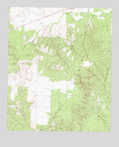
Pitchfork Flats, TX USGS Topographic Map
Click on map above to begin viewing in our Map Viewer.

This topographic map contains these locations and features:
Feature Name Type Latitude Longitude GNIS ID View Map
Brushy CreekStreamN33.5729°W100.4887°1353058View Map
Cedar Point CanyonValleyN33.5378°W100.3822°1354144View Map
Chalk WindmillLocaleN33.5954°W100.4823°1354273View Map
China CreekStreamN33.6104°W100.4473°1354425View Map
Dog Town MountainSummitN33.6170°W100.3901°1356126View Map
Dog Town Mountain WindmillLocaleN33.6065°W100.3868°1356127View Map
Dugout WindmillLocaleN33.5015°W100.4223°1356423View Map
Dugout WindmillLocaleN33.5565°W100.4626°1356424View Map
E Vat WindmillLocaleN33.6106°W100.4823°1356522View Map
F A CanyonValleyN33.6090°W100.4460°1357142View Map
F A WindmillLocaleN33.5951°W100.4412°1357144View Map
Fa WindmillLocaleN33.5773°W100.4168°1357150View Map
Graves HollowValleyN33.5027°W100.4402°1358338View Map
Harper Young CanyonValleyN33.5468°W100.3834°1358828View Map
Hollywood WindmillLocaleN33.5909°W100.3879°1359455View Map
Krit WindmillLocaleN33.6243°W100.4643°1360770View Map
Long Canyon CreekStreamN33.6156°W100.4232°1361714View Map
Lynn CanyonValleyN33.6116°W100.4249°1362002View Map
Lynn Canyon WindmillLocaleN33.6054°W100.4240°1362003View Map
North F A WindmillLocaleN33.6087°W100.4618°1364040View Map
Owens WindmillLocaleN33.5351°W100.4657°1364635View Map
Pitchfork FlatsFlatN33.5359°W100.4418°1365354View Map
Pitchfork Flats WindmillLocaleN33.5365°W100.4254°1365355View Map
Ratliff Pen WindmillLocaleN33.5295°W100.3843°1366027View Map
Ray CanyonValleyN33.6163°W100.3767°1366067View Map
Ray Hollow WindmillLocaleN33.5815°W100.3798°1366068View Map
Rider CreekStreamN33.5218°W100.3940°1366442View Map
Saline CreekStreamN33.6184°W100.4040°1367365View Map
Salt CreekStreamN33.6170°W100.4007°1367390View Map
Salt CreekStreamN33.5773°W100.4859°1367407View Map
Texas No Name Number 20 DamDamN33.5068°W100.4437°1864462View Map
Wall CanyonValleyN33.5380°W100.3923°1370776View Map
Wall Canyon WindmillLocaleN33.5618°W100.4159°1370777View Map

Note: Coordinates in the location and feature list above are referenced to NAD83 datum.


Copyright (C) 2008-2025 Ryan Niemi / Sunset Dynamics ... All Rights Reserved