TopoQuest Logo
Do you find TopoQuest useful?
Help keep TopoQuest running and adding new maps/features by donating!
Bitcoin:  19c7KJd3qBynnjoSw5npx9KScwjBe4ifkT
Litecoin:  LXs6TkuXGGXo1vDsWCkWVdjQX94eUKd6ui
Home View Maps Find Maps Find Places Resources & Links


Pitts Point, Kentucky Topographic Map

USGS Map Title: Pitts Point, KY
USGS Map MRC: 37085H7
DRG (GeoTIFF) Download: o37085h7.tif


Neighboring USGS Topographic Map Quads:


  Kosmosdale, KY  
38085A8
 

  Valley Station, KY  
38085A7
 

  Brooks, KY  
38085A6
 

  Fort Knox, KY  
37085H8
 

  Pitts Point, KY  
37085H7
 

  Shepherdsville, KY  
37085H6
 

  Vine Grove, KY  
37085G8
 

  Colesburg, KY  
37085G7
 

  Lebanon Junction, KY  
37085G6


Map MRC Location:

N38°
W86°
N38°
W85°
H8 H7 H6 H5 H4 H3 H2 H1
G8 G7 G6 G5 G4 G3 G2 G1
F8 F7 F6 F5 F4 F3 F2 F1
E8 E7 E6 E5 E4 E3 E2 E1
D8 D7 D6 D5 D4 D3 D2 D1
C8 C7 C6 C5 C4 C3 C2 C1
B8 B7 B6 B5 B4 B3 B2 B1
A8 A7 A6 A5 A4 A3 A2 A1
N37°
W86°
N37°
W85°

Pitts Point, KY USGS 1:24K Topographic Map Preview:
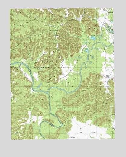
Pitts Point, KY USGS Topographic Map
Click on map above to begin viewing in our Map Viewer.

This topographic map contains these locations and features:
Feature Name Type Latitude Longitude GNIS ID View Map
Anderson CemeteryCemeteryN37.9842°W85.8575°485936View Map
Atherton FlatsFlatN37.8962°W85.8275°486115View Map
Beech GrovePopulated PlaceN37.9340°W85.7558°507476View Map
Bills LakeLakeN37.9864°W85.7514°487313View Map
Carr CemeteryCemeteryN37.9062°W85.8444°488970View Map
Cedar PointCliffN37.9306°W85.8283°489234View Map
Chappel CemeteryCemeteryN37.9609°W85.8730°489359View Map
Congrove CemeteryCemeteryN37.9364°W85.8297°489954View Map
Crandall CemeteryCemeteryN37.9167°W85.8583°490280View Map
Cundiff CemeteryCemeteryN37.9323°W85.7530°490487View Map
Cupio HillSummitN37.9928°W85.8655°490490View Map
Dawson KnobSummitN37.9212°W85.7866°490693View Map
Duck LakeLakeN37.9711°W85.7741°491251View Map
Dunaway HillSummitN37.9956°W85.8530°491282View Map
Flat LickStreamN37.8834°W85.8402°492199View Map
Fort Knox DivisionCivilN37.9345°W85.8174°1937007View Map
Froman CemeteryCemeteryN37.9151°W85.8297°492572View Map
Froman CemeteryCemeteryN37.9659°W85.8177°492573View Map
Froman HollowValleyN37.9206°W85.8380°492575View Map
Froman LakeLakeN37.9784°W85.7532°492577View Map
Glenn CemeteryCemeteryN37.8953°W85.8005°492899View Map
Glenn MeadowsFlatN37.9267°W85.8063°492901View Map
Gray HillSummitN37.8828°W85.8614°493201View Map
Grenwells PondLakeN37.9433°W85.7841°493367View Map
Hardy CemeteryCemeteryN37.9212°W85.8308°493736View Map
Hays CemeteryCemeteryN37.8934°W85.8344°493935View Map
Hays SchoolSchoolN37.8767°W85.8038°493940View Map
Heartfield HollowValleyN37.9999°W85.8275°493978View Map
Holsclaw CemeteryCemeteryN37.9403°W85.8222°494433View Map
Hudic LakeLakeN37.9531°W85.7764°494721View Map
Indian RunStreamN37.8883°W85.8132°2742433View Map
Jeff Lee RidgeRidgeN37.8987°W85.7902°495187View Map
Johnson CemeteryCemeteryN37.9726°W85.7952°495388View Map
Joyce CemeteryCemeteryN37.9470°W85.7822°495534View Map
Lee CemeteryCemeteryN37.8970°W85.8102°496162View Map
Long Lick CreekStreamN37.9642°W85.7533°497124View Map
Marcum LakeLakeN37.9723°W85.7659°497534View Map
Mountain TopSummitN37.9230°W85.7836°2742446View Map
Mud CreekStreamN37.9473°W85.7844°498981View Map
Mumford CemeteryCemeteryN37.8973°W85.7502°499101View Map
Myers CemeteryCemeteryN37.9831°W85.8227°499147View Map
Nichols Fire DepartmentBuildingN37.9986°W85.7621°2636460View Map
Pearl PondLakeN37.9522°W85.7920°500334View Map
Pitts PointPopulated PlaceN37.9167°W85.8261°508831View Map
Raridan HollowValleyN37.9561°W85.8505°501579View Map
Ridgeway CemeteryCemeteryN37.9731°W85.8502°501844View Map
Rising Sun RidgeRidgeN37.9892°W85.8069°501967View Map
Rodgers HollowValleyN37.9486°W85.8463°502268View Map
Rolling ForkStreamN37.9187°W85.8302°502293View Map
Shepherd CemeteryCemeteryN37.9934°W85.7872°503346View Map
Snellen CemeteryCemeteryN37.9073°W85.8177°503850View Map
Suellen CemeteryCemeteryN37.9053°W85.8102°504626View Map
Sugar LoafSummitN37.9012°W85.8427°504671View Map
The Dug HillSummitN37.9478°W85.8172°505119View Map
The KnobsSummitN37.9770°W85.8341°505127View Map
Troutman CemeteryCemeteryN37.9509°W85.8041°505520View Map
Viers CemeteryCemeteryN37.8939°W85.7819°506047View Map
WBUL-AM (Shepherdsville)TowerN37.9245°W85.7550°517901View Map
Wilcox LakeReservoirN37.9595°W85.7826°506721View Map
Wilcox Number 3 LakeLakeN37.9665°W85.7839°509526View Map
Woodland CreekStreamN37.9670°W85.7680°507098View Map
Woods LakeLakeN37.9473°W85.7790°507121View Map
Wooldridge CemeteryCemeteryN37.9051°W85.8527°509878View Map
Zazios PondLakeN37.9617°W85.7728°507269View Map

Note: Coordinates in the location and feature list above are referenced to NAD83 datum.


Copyright (C) 2008-2024 Ryan Niemi / Sunset Dynamics ... All Rights Reserved