TopoQuest Logo
Do you find TopoQuest useful?
Help keep TopoQuest running and adding new maps/features by donating!
Bitcoin:  19c7KJd3qBynnjoSw5npx9KScwjBe4ifkT
Litecoin:  LXs6TkuXGGXo1vDsWCkWVdjQX94eUKd6ui
Home View Maps Find Maps Find Places Resources & Links


Placida, Florida Topographic Map

USGS Map Title: Placida, FL
USGS Map MRC: 26082G3
DRG (GeoTIFF) Download: o26082g3.tif


Neighboring USGS Topographic Map Quads:


  Englewood NW, FL  
26082H4
 

  Englewood, FL  
26082H3
 

  El Jobean, FL  
26082H2


  Placida, FL  
26082G3
 

  Punta Gorda SW, FL  
26082G2


  Port Boca Grande, FL  
26082F3
 

  Bokeelia, FL  
26082F2


Map MRC Location:

N27°
W83°
N27°
W82°
H8 H7 H6 H5 H4 H3 H2 H1
G8 G7 G6 G5 G4 G3 G2 G1
F8 F7 F6 F5 F4 F3 F2 F1
E8 E7 E6 E5 E4 E3 E2 E1
D8 D7 D6 D5 D4 D3 D2 D1
C8 C7 C6 C5 C4 C3 C2 C1
B8 B7 B6 B5 B4 B3 B2 B1
A8 A7 A6 A5 A4 A3 A2 A1
N26°
W83°
N26°
W82°

Placida, FL USGS 1:24K Topographic Map Preview:
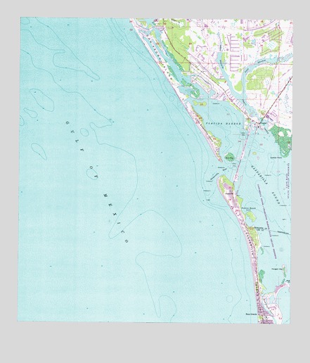
Placida, FL USGS Topographic Map
Click on map above to begin viewing in our Map Viewer.

This topographic map contains these locations and features:
Feature Name Type Latitude Longitude GNIS ID View Map
Amberjack CoveCanalN26.8552°W82.2899°2493889View Map
Bird KeyIslandN26.8187°W82.2784°278810View Map
Blue Heron CoveBayN26.8512°W82.2972°2493892View Map
Boca Grande BayouBayN26.7540°W82.2587°279120View Map
Boca Grande DivisionCivilN26.7520°W82.2681°1935696View Map
Boca Grande Post OfficePost OfficeN26.7503°W82.2618°2768122View Map
Bocilla InletBayN26.8630°W82.3142°2493894View Map
Bocilla IslandIslandN26.8626°W82.3157°300317View Map
Cape HazePopulated PlaceN26.8503°W82.2943°280002View Map
Captains CutBayN26.8516°W82.2917°2493900View Map
Catfish PointCapeN26.8187°W82.2540°280149View Map
Charlotte County Fire and Emergency Medical Services Station 14BuildingN26.8517°W82.2878°2131626View Map
Coral CoveLakeN26.8424°W82.2763°2493902View Map
Coral CreekStreamN26.8278°W82.2601°280798View Map
Coral Creek AirportAirportN26.8576°W82.2503°309830View Map
Don Pedro IslandIslandN26.8634°W82.3159°281671View Map
Don Pedro Island State ParkParkN26.8712°W82.3207°1946066View Map
East Branch Coral CreekStreamN26.8434°W82.2731°281951View Map
Englewood Area Fire Department Control District Station 76BuildingN26.8517°W82.2878°2644242View Map
Galleon CoveCanalN26.8438°W82.2842°2493906View Map
GasparillaPopulated PlaceN26.8048°W82.2768°294783View Map
Gasparilla IslandIslandN26.7723°W82.2662°282961View Map
Gasparilla Island Fire and RescueBuildingN26.8683°W82.3155°2644482View Map
Gasparilla PassBayN26.8130°W82.2851°282962View Map
Gasparilla SoundBayN26.7986°W82.2516°282963View Map
Hoagen KeyIslandN26.7723°W82.2529°284056View Map
Jack PointCapeN26.7670°W82.2509°284662View Map
Kettle HarborHarborN26.8512°W82.3007°300315View Map
Lemon LakeLakeN26.8739°W82.3033°2493916View Map
Little Gasparilla IslandIslandN26.8298°W82.2909°285689View Map
Little Gasparilla Pass (historical)GutN26.8403°W82.2998°297499View Map
Peekins Ranch CoveBayN26.7980°W82.2710°288657View Map
Pelican BayBayN26.8450°W82.2867°2493926View Map
PlacidaPopulated PlaceN26.8323°W82.2648°289015View Map
Placida HarborBayN26.8313°W82.2806°289017View Map
Placida Post OfficePost OfficeN26.8554°W82.2927°2768219View Map
Rambler HoleBayN26.8460°W82.2987°300316View Map
Rotunda-WestPopulated PlaceN26.8578°W82.2948°300314View Map
West Branch Coral CreekStreamN26.8434°W82.2731°293040View Map
WSEB-FM (Englewood)TowerN26.8637°W82.2982°310181View Map

Note: Coordinates in the location and feature list above are referenced to NAD83 datum.


Copyright (C) 2008-2024 Ryan Niemi / Sunset Dynamics ... All Rights Reserved