TopoQuest Logo
Do you find TopoQuest useful?
Help keep TopoQuest running and adding new maps/features by donating!
Bitcoin:  19c7KJd3qBynnjoSw5npx9KScwjBe4ifkT
Litecoin:  LXs6TkuXGGXo1vDsWCkWVdjQX94eUKd6ui
Home View Maps Find Maps Find Places Resources & Links


Plains, Montana Topographic Map

USGS Map Title: Plains, MT
USGS Map MRC: 47114D8
DRG (GeoTIFF) Download: o47114d8.tif


Neighboring USGS Topographic Map Quads:


  Big Hole Peak, MT  
47115E1
 

  Weeksville, MT  
47114E8
 

  Baldy Lake, MT  
47114E7
 

  Sunset Peak, MT  
47115D1
 

  Plains, MT  
47114D8
 

  Paradise, MT  
47114D7
 

  Saint Regis, MT  
47115C1
 

  Keystone Peak, MT  
47114C8
 

  Quinns Hot Springs, MT  
47114C7


Map MRC Location:

N48°
W115°
N48°
W114°
H8 H7 H6 H5 H4 H3 H2 H1
G8 G7 G6 G5 G4 G3 G2 G1
F8 F7 F6 F5 F4 F3 F2 F1
E8 E7 E6 E5 E4 E3 E2 E1
D8 D7 D6 D5 D4 D3 D2 D1
C8 C7 C6 C5 C4 C3 C2 C1
B8 B7 B6 B5 B4 B3 B2 B1
A8 A7 A6 A5 A4 A3 A2 A1
N47°
W115°
N47°
W114°

Plains, MT USGS 1:24K Topographic Map Preview:
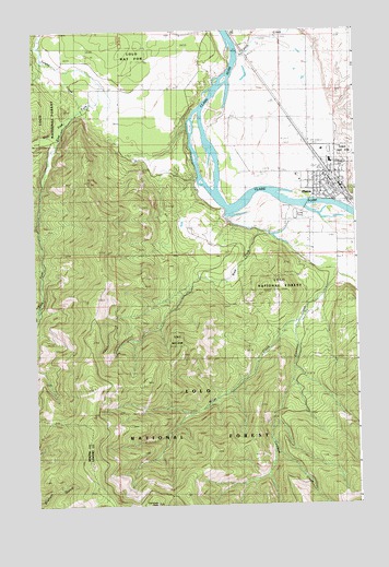
Plains, MT USGS Topographic Map
Click on map above to begin viewing in our Map Viewer.

This topographic map contains these locations and features:
Feature Name Type Latitude Longitude GNIS ID View Map
19N26W03ACBC01 WellWellN47.4372°W114.8940°822916View Map
19N26W03BDAC01 WellWellN47.4374°W114.8957°822920View Map
20N26W15ACAB01 WellWellN47.4944°W114.8910°823383View Map
20N26W15BAAD01 WellWellN47.4972°W114.8943°823397View Map
20N26W16BADA01 WellWellN47.4963°W114.9154°823394View Map
20N26W23CCBA01 WellWellN47.4727°W114.8829°823248View Map
20N26W27DBBC01 WellWellN47.4610°W114.8940°823128View Map
20N26W27DDBC01 WellWellN47.4569°W114.8876°823081View Map
20N27W13DDCD01 WellWellN47.4852°W114.9701°823334View Map
20N27W24BDBC01 WellWellN47.4794°W114.9801°823296View Map
Allen (historical)LocaleN47.4569°W114.8765°1780976View Map
Christian and Missionary Alliance ChurchChurchN47.4602°W114.8968°1780873View Map
Clark Fork Baptist ChurchChurchN47.4602°W114.8829°1780867View Map
Clark Fork Valley ClinicHospitalN47.4683°W114.8882°1780890View Map
Clark Fork Valley HospitalHospitalN47.4685°W114.8882°1780888View Map
Clark Fork Valley Hospital HeliportAirportN47.4680°W114.8896°806500View Map
Clark Fork Valley Nursing HomeHospitalN47.4683°W114.8882°1780889View Map
Combest CreekStreamN47.4505°W114.9254°781536View Map
Combest PeakSummitN47.3752°W114.9543°781537View Map
Crossroads Motel and RV ParkLocaleN47.4577°W114.8782°1780907View Map
East Fork Swamp CreekStreamN47.4724°W114.9899°782910View Map
First Lutheran ChurchChurchN47.4572°W114.8885°1780872View Map
Lower Lettermen MineMineN47.4285°W114.8946°805157View Map
Lynch CemeteryCemeteryN47.4559°W114.8764°1780927View Map
Lynch CreekStreamN47.4935°W114.9204°786731View Map
Miller CreekStreamN47.4238°W114.8979°787401View Map
Montro Gold MineMineN47.4355°W114.9010°805120View Map
Pardee SloughLakeN47.4874°W114.9176°794310View Map
PlainsPopulated PlaceN47.4602°W114.8829°788983View Map
PlainsLocaleN47.4580°W114.8812°1780951View Map
Plains - Paradise Rural Fire DistrictBuildingN47.4742°W114.8992°2546742View Map
Plains AirportAirportN47.4743°W114.9056°806499View Map
Plains Bible ChapelChurchN47.4602°W114.8829°1780868View Map
Plains CemeteryCemeteryN47.4728°W114.8817°1780928View Map
Plains Community AmbulanceBuildingN47.4597°W114.8798°2637889View Map
Plains District Ranger OfficeLocaleN47.4658°W114.8840°794311View Map
Plains Feed and Grain ElevatorLocaleN47.4624°W114.8912°1780882View Map
Plains Golf CourseLocaleN47.4944°W114.9121°1780913View Map
Plains Police DepartmentBuildingN47.4587°W114.8837°2548911View Map
Plains Post OfficePost OfficeN47.4618°W114.8874°1780963View Map
Plains Public LibraryBuildingN47.4602°W114.8829°1780895View Map
Plains Public SchoolsSchoolN47.4652°W114.8849°1780849View Map
Plains United Methodist ChurchChurchN47.4602°W114.8829°1780869View Map
Plains Volunteer Fire DepartmentBuildingN47.4567°W114.8892°2546493View Map
Rittenour ClinicHospitalN47.4569°W114.8904°1780887View Map
Saint James Catholic ChurchChurchN47.4602°W114.8829°1780870View Map
Sanders County FairgroundsLocaleN47.4510°W114.8954°1780883View Map
The Church of Jesus Christ of Latter Day SaintsChurchN47.4602°W114.8829°1780871View Map
Town of PlainsCivilN47.4603°W114.8843°2413141View Map
Upper Lettermen MineMineN47.4283°W114.8968°805156View Map
West Fork Combest CreekStreamN47.4477°W114.9143°793001View Map
West Fork Swamp CreekStreamN47.4727°W114.9899°793084View Map

Note: Coordinates in the location and feature list above are referenced to NAD83 datum.


Copyright (C) 2008-2025 Ryan Niemi / Sunset Dynamics ... All Rights Reserved