TopoQuest Logo
Do you find TopoQuest useful?
Help keep TopoQuest running and adding new maps/features by donating!
Bitcoin:  19c7KJd3qBynnjoSw5npx9KScwjBe4ifkT
Litecoin:  LXs6TkuXGGXo1vDsWCkWVdjQX94eUKd6ui
Home View Maps Find Maps Find Places Resources & Links


Plainville, Kansas Topographic Map

USGS Map Title: Plainville, KS
USGS Map MRC: 39099B3
DRG (GeoTIFF) Download: o39099b3.tif


Neighboring USGS Topographic Map Quads:


  Stockton SW, KS  
39099C4
 

  Stockton SE, KS  
39099C3
 

  Twin Mound, KS  
39099C2
 

  Zurich, KS  
39099B4
 

  Plainville, KS  
39099B3
 

  Codell, KS  
39099B2
 

  Plainville SW, KS  
39099A4
 

  Plainville SE, KS  
39099A3
 

  Turkville, KS  
39099A2


Map MRC Location:

N40°
W100°
N40°
W99°
H8 H7 H6 H5 H4 H3 H2 H1
G8 G7 G6 G5 G4 G3 G2 G1
F8 F7 F6 F5 F4 F3 F2 F1
E8 E7 E6 E5 E4 E3 E2 E1
D8 D7 D6 D5 D4 D3 D2 D1
C8 C7 C6 C5 C4 C3 C2 C1
B8 B7 B6 B5 B4 B3 B2 B1
A8 A7 A6 A5 A4 A3 A2 A1
N39°
W100°
N39°
W99°

Plainville, KS USGS 1:24K Topographic Map Preview:
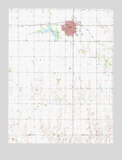
Plainville, KS USGS Topographic Map
Click on map above to begin viewing in our Map Viewer.

This topographic map contains these locations and features:
Feature Name Type Latitude Longitude GNIS ID View Map
City of PlainvilleCivilN39.2313°W99.3012°2396222View Map
First Baptist ChurchChurchN39.2239°W99.2989°2690618View Map
First Christian ChurchChurchN39.2321°W99.3020°2690619View Map
First Lutheran ChurchChurchN39.2279°W99.2991°2690620View Map
Harvest Christian FellowshipChurchN39.2239°W99.2976°2688692View Map
PlainvillePopulated PlaceN39.2347°W99.2982°472441View Map
Plainville Airpark (historical)AirportN39.1945°W99.3034°481317View Map
Plainville Ambulance ServiceBuildingN39.2250°W99.2998°2696565View Map
Plainville CemeteryCemeteryN39.2265°W99.2874°472442View Map
Plainville Church of the NazareneChurchN39.2339°W99.3047°2690390View Map
Plainville City HallBuildingN39.2347°W99.3007°2693072View Map
Plainville Elementary SchoolSchoolN39.2307°W99.2966°480327View Map
Plainville High SchoolSchoolN39.2317°W99.2961°480326View Map
Plainville Memorial LibraryBuildingN39.2337°W99.3000°2694866View Map
Plainville Police DepartmentBuildingN39.2346°W99.3008°2503913View Map
Plainville Post OfficePost OfficeN39.2336°W99.3007°2693921View Map
Plainville Rural Fire DepartmentBuildingN39.2348°W99.3034°2111730View Map
Plainville Saddle Club ArenaLocaleN39.2381°W99.2937°2692593View Map
Plainville Township LakeReservoirN39.2272°W99.3219°472440View Map
Plainville United Methodist ChurchChurchN39.2247°W99.3043°2689523View Map
Plainville Wastewater PlantLocaleN39.2182°W99.2831°2691990View Map
Rooks County Health CenterHospitalN39.2475°W99.2964°2499126View Map
Sacred Heart Catholic ChurchChurchN39.2361°W99.2975°2690656View Map
Sacred Heart Elementary SchoolSchoolN39.2369°W99.2978°480328View Map
Township 11CivilN39.2343°W99.2888°472373View Map

Note: Coordinates in the location and feature list above are referenced to NAD83 datum.


Copyright (C) 2008-2025 Ryan Niemi / Sunset Dynamics ... All Rights Reserved