TopoQuest Logo
Do you find TopoQuest useful?
Help keep TopoQuest running and adding new maps/features by donating!
Bitcoin:  19c7KJd3qBynnjoSw5npx9KScwjBe4ifkT
Litecoin:  LXs6TkuXGGXo1vDsWCkWVdjQX94eUKd6ui
Home View Maps Find Maps Find Places Resources & Links


Plant City West, Florida Topographic Map

USGS Map Title: Plant City West, FL
USGS Map MRC: 28082A2
DRG (GeoTIFF) Download: o28082a2.tif


Neighboring USGS Topographic Map Quads:


  Wesley Chapel, FL  
28082B3
 

  Zephyrhills, FL  
28082B2
 

  Socrum, FL  
28082B1
 

  Thonotosassa, FL  
28082A3
 

  Plant City West, FL  
28082A2
 

  Plant City East, FL  
28082A1
 

  Brandon, FL  
27082H3
 

  Dover, FL  
27082H2
 

  Nichols, FL  
27082H1


Map MRC Location:

N29°
W83°
N29°
W82°
H8 H7 H6 H5 H4 H3 H2 H1
G8 G7 G6 G5 G4 G3 G2 G1
F8 F7 F6 F5 F4 F3 F2 F1
E8 E7 E6 E5 E4 E3 E2 E1
D8 D7 D6 D5 D4 D3 D2 D1
C8 C7 C6 C5 C4 C3 C2 C1
B8 B7 B6 B5 B4 B3 B2 B1
A8 A7 A6 A5 A4 A3 A2 A1
N28°
W83°
N28°
W82°

Plant City West, FL USGS 1:24K Topographic Map Preview:
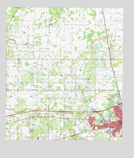
Plant City West, FL USGS Topographic Map
Click on map above to begin viewing in our Map Viewer.

This topographic map contains these locations and features:
Feature Name Type Latitude Longitude GNIS ID View Map
Abraham AcresPopulated PlaceN28.0562°W82.1940°2482138View Map
Aldermans AdditionPopulated PlaceN28.0151°W82.1321°2482158View Map
Alexanders AcresPopulated PlaceN28.0593°W82.1474°2482159View Map
AlfordPopulated PlaceN28.0743°W82.2055°2482162View Map
All GreenPopulated PlaceN28.0234°W82.2236°2482167View Map
Allen PeacockPopulated PlaceN28.0388°W82.1809°2482169View Map
Alligator BobsPopulated PlaceN28.0743°W82.2045°2482175View Map
Ancient OakPopulated PlaceN28.0570°W82.2009°2482196View Map
Ansley TerracePopulated PlaceN28.0591°W82.1715°2482209View Map
AntiochPopulated PlaceN28.0470°W82.2490°294654View Map
Antioch PlacePopulated PlaceN28.0739°W82.2479°2482211View Map
Appling WoodsPopulated PlaceN28.0416°W82.1970°2482215View Map
Arbor AcresPopulated PlaceN28.0074°W82.2344°2482217View Map
Armwood High SchoolSchoolN28.0167°W82.2455°297788View Map
Ashlin EstatesPopulated PlaceN28.0523°W82.1804°2481469View Map
B And J EstatesPopulated PlaceN28.0460°W82.1970°2481493View Map
Baker AcresPopulated PlaceN28.0528°W82.1907°2481496View Map
Bartons Country EstatesPopulated PlaceN28.0569°W82.2099°2481520View Map
Bellehurst HeightsPopulated PlaceN28.0046°W82.1270°2481590View Map
Bennett AcresPopulated PlaceN28.0497°W82.2254°2481603View Map
Bennett RanchPopulated PlaceN28.0416°W82.2104°2481604View Map
Bethlehem ChurchChurchN28.0153°W82.2037°278565View Map
Blain AcresPopulated PlaceN28.0421°W82.1332°2481632View Map
Blue Sky AcresPopulated PlaceN28.0697°W82.1560°2481642View Map
Boone AcresPopulated PlaceN28.0489°W82.1860°2481654View Map
Branch HavenPopulated PlaceN28.0364°W82.1859°2481671View Map
Browning AcresPopulated PlaceN28.0891°W82.1281°2482626View Map
Bryan Plant City Elementary SchoolSchoolN28.0176°W82.1433°279529View Map
BurchwoodPopulated PlaceN28.0125°W82.1562°2482661View Map
Burchwood ParkParkN28.0134°W82.1565°279685View Map
Burton Memorial LibraryBuildingN28.0185°W82.1262°2481142View Map
Campbell Creek WoodsPopulated PlaceN28.0490°W82.2421°2482695View Map
Campbells CovePopulated PlaceN28.0626°W82.2172°2482697View Map
Cannen OaksPopulated PlaceN28.0462°W82.1475°2482707View Map
Carolyn GardensPopulated PlaceN28.0380°W82.1318°2482732View Map
CarylwoodPopulated PlaceN28.0203°W82.2223°2482764View Map
Cattlemans CovePopulated PlaceN28.0859°W82.1558°2482787View Map
Cedar OaksPopulated PlaceN28.0826°W82.2440°2482793View Map
Cedar RunPopulated PlaceN28.0216°W82.1435°2482794View Map
ChadamPopulated PlaceN28.0486°W82.1777°2482802View Map
Cherry HillPopulated PlaceN28.0261°W82.1302°2482819View Map
Church of Christ Palm HarborChurchN28.0767°W82.1387°302972View Map
Cicello EstatesPopulated PlaceN28.0562°W82.2315°2482833View Map
Circle S FarmsLocaleN28.0342°W82.2428°2585747View Map
Citrus LandingPopulated PlaceN28.0026°W82.1257°2482841View Map
Clay GullyValleyN28.1114°W82.2398°280509View Map
Clover Pointe EstatesPopulated PlaceN28.0553°W82.1851°2482866View Map
Connelly EstatePopulated PlaceN28.0684°W82.1517°2482900View Map
Constellation AcresPopulated PlaceN28.0713°W82.1524°2482901View Map
Cooks CovePopulated PlaceN28.0806°W82.1908°2482904View Map
Cooper HollowPopulated PlaceN28.0482°W82.2173°2482906View Map
Cork AcademyLocaleN28.0470°W82.1748°280837View Map
Cork Elementary SchoolSchoolN28.0502°W82.1759°297776View Map
Cork Knights Volunteer Fire Department Station 26BuildingN28.0473°W82.1889°2131653View Map
Cork PrairieFlatN28.0353°W82.1515°280840View Map
Country Oaks EstatesPopulated PlaceN28.0186°W82.2260°2482934View Map
Country TrailsPopulated PlaceN28.0721°W82.2314°2482939View Map
Courier FieldParkN28.0197°W82.1259°280898View Map
Cox AcresPopulated PlaceN28.0626°W82.2429°2482955View Map
CrumleyPopulated PlaceN28.0876°W82.2160°2482983View Map
Cypress ReservePopulated PlaceN28.0743°W82.2204°2482250View Map
DavisPopulated PlaceN28.0177°W82.1322°2482267View Map
Destinys WayPopulated PlaceN28.0211°W82.2071°2482292View Map
Devane EstatesPopulated PlaceN28.0234°W82.1424°2482296View Map
DickeyPopulated PlaceN28.0261°W82.2458°2482301View Map
DilportsPopulated PlaceN28.1112°W82.2275°2482305View Map
Dixie GardensPopulated PlaceN28.0284°W82.1278°2482308View Map
Dormany Country EstatesPopulated PlaceN28.0876°W82.2183°2482327View Map
Dormany EstatesPopulated PlaceN28.0963°W82.2035°2482328View Map
Dormany OaksPopulated PlaceN28.0063°W82.1861°2482329View Map
Dover GrovesPopulated PlaceN28.0123°W82.2347°2482333View Map
Doyer ParkParkN28.0025°W82.2270°281742View Map
El PinarPopulated PlaceN28.0154°W82.1531°2482414View Map
EmpirePopulated PlaceN28.0019°W82.1357°2482436View Map
Eunice EstatesPopulated PlaceN28.0157°W82.1606°2482460View Map
EurcellesPopulated PlaceN28.0857°W82.2344°2482461View Map
Evanell EstatesPopulated PlaceN28.0441°W82.2349°2482465View Map
Family RanchPopulated PlaceN28.1055°W82.2224°2482492View Map
Farkas EstatesPopulated PlaceN28.0064°W82.2039°2482496View Map
Fletcher Country EstatesPopulated PlaceN28.0986°W82.2383°2482523View Map
Fletchers PondPopulated PlaceN28.0977°W82.2388°2482527View Map
FlowersPopulated PlaceN28.0772°W82.2059°2482540View Map
Forbes AcresPopulated PlaceN28.0123°W82.1891°2482541View Map
Forest OakPopulated PlaceN28.0128°W82.1406°2482547View Map
Forest Park EastPopulated PlaceN28.0128°W82.1400°2482550View Map
Four Pine EstatesPopulated PlaceN28.0862°W82.2271°2482557View Map
Franklin Creek EstatesPopulated PlaceN28.0818°W82.2310°2483215View Map
Franklin ReservePopulated PlaceN28.0857°W82.2327°2483217View Map
Franklin WoodlandsPopulated PlaceN28.0818°W82.2306°2483218View Map
Fritzke AcresPopulated PlaceN28.0373°W82.2176°2483227View Map
Fritzke EstatesPopulated PlaceN28.0368°W82.2138°2483228View Map
Fullenkamp AcresPopulated PlaceN28.0514°W82.2060°2483230View Map
Gaineys AcresPopulated PlaceN28.1072°W82.1476°2483236View Map
Gallagher AcresPopulated PlaceN28.0389°W82.2342°2483237View Map
Gallagher EstatesPopulated PlaceN28.0428°W82.2379°2483238View Map
Gamelou EstatesPopulated PlaceN28.0752°W82.1803°2483244View Map
Gator TrailPopulated PlaceN28.0658°W82.1770°2483261View Map
Gavin EstatesPopulated PlaceN28.0026°W82.2270°2483263View Map
Gillett AcresPopulated PlaceN28.0430°W82.2478°2483280View Map
Godins Golden AcresPopulated PlaceN28.0182°W82.2227°2483291View Map
Gough Pless EstatesPopulated PlaceN28.0890°W82.2214°2483316View Map
Grace AcresPopulated PlaceN28.0424°W82.2132°2483317View Map
Green PasturesPopulated PlaceN28.0491°W82.2292°2483336View Map
Green ValleyPopulated PlaceN28.0090°W82.1877°2483338View Map
GreenleafPopulated PlaceN28.0061°W82.1272°2483344View Map
GrimwoldPopulated PlaceN28.0243°W82.1313°2483352View Map
Grove ManorPopulated PlaceN28.0639°W82.1788°2483355View Map
Hales AcresPopulated PlaceN28.0496°W82.2446°2483374View Map
Hales EstatesPopulated PlaceN28.0485°W82.2458°2483375View Map
Hallman EstatesPopulated PlaceN28.1047°W82.2105°2483380View Map
Ham AcresPopulated PlaceN28.0675°W82.1372°2483381View Map
HartlinePopulated PlaceN28.0175°W82.1385°2483425View Map
Harwell EstatesPopulated PlaceN28.0190°W82.2016°2483428View Map
HastingsPopulated PlaceN28.0648°W82.2061°2483429View Map
Hawk WoodsPopulated PlaceN28.0369°W82.1759°2483431View Map
Helen Winter GardensPopulated PlaceN28.0781°W82.1731°2483443View Map
HendersonPopulated PlaceN28.0133°W82.1322°2483445View Map
Herndon EstatesPopulated PlaceN28.0662°W82.2137°2483458View Map
Herndons MillPopulated PlaceN28.0891°W82.1412°2483459View Map
Highland GrovePopulated PlaceN28.0525°W82.2033°2483497View Map
Highland Pines EstatesPopulated PlaceN28.0954°W82.2430°2483504View Map
Highway HeightsPopulated PlaceN28.0156°W82.1420°2483509View Map
Hillsboro ParkPopulated PlaceN28.0308°W82.1283°2483521View Map
Hilltop PreservePopulated PlaceN28.0125°W82.2016°2483530View Map
Holloman Branch EstatesPopulated PlaceN28.1018°W82.2223°2483544View Map
Homeland ParkPopulated PlaceN28.0044°W82.1260°2483554View Map
Horn AcresPopulated PlaceN28.0404°W82.1571°2483561View Map
Huckleberry RanchPopulated PlaceN28.0681°W82.2193°2483567View Map
Hussar AcresPopulated PlaceN28.0196°W82.1840°2483583View Map
Interchange 14CrossingN28.0228°W82.2446°2481849View Map
Interchange 17CrossingN28.0269°W82.1869°2481851View Map
Interchange 18CrossingN28.0272°W82.1531°2481853View Map
Interchange 21CrossingN28.0352°W82.1257°2481858View Map
Island Pond EstatesPopulated PlaceN28.0515°W82.1646°2483616View Map
Jenson HeightsPopulated PlaceN28.0092°W82.1634°2483635View Map
Jerkins AcresPopulated PlaceN28.0096°W82.2468°2483636View Map
Jim Kirkland AcresPopulated PlaceN28.0407°W82.2134°2483641View Map
Julieann AcresPopulated PlaceN28.0901°W82.2066°2483656View Map
Jurnigan AcresPopulated PlaceN28.0508°W82.1522°2483659View Map
KeenePopulated PlaceN28.0961°W82.1516°2483675View Map
Keene Country AcresPopulated PlaceN28.0648°W82.1566°2483676View Map
KellersPopulated PlaceN28.0053°W82.1260°2483680View Map
KennyPopulated PlaceN28.0334°W82.2324°2483685View Map
Key Woods RanchPopulated PlaceN28.0428°W82.1757°2483690View Map
KilgorePopulated PlaceN28.0240°W82.1252°2483713View Map
Kilgore Railroad StationLocaleN28.0653°W82.1340°300082View Map
Kinard CovePopulated PlaceN28.0589°W82.2346°2483720View Map
Kinard EstatesPopulated PlaceN28.0635°W82.2336°2483721View Map
Kingston CityPopulated PlaceN28.1159°W82.2307°2483729View Map
KnightsPopulated PlaceN28.0764°W82.1376°285164View Map
Knights Elementary SchoolSchoolN28.0755°W82.1553°297777View Map
Krause FarmsPopulated PlaceN28.0013°W82.2457°2483749View Map
Lakewood PlacePopulated PlaceN28.0191°W82.1411°2483852View Map
Lanes CornerPopulated PlaceN28.0463°W82.2166°2482993View Map
Law AcresPopulated PlaceN28.0445°W82.2110°2483003View Map
Lazy OaksPopulated PlaceN28.0563°W82.2248°2483008View Map
Leaning PinePopulated PlaceN28.0610°W82.1478°2483011View Map
Lebanon ChurchChurchN28.0039°W82.1868°285419View Map
Leslie AcresPopulated PlaceN28.0635°W82.2295°2483030View Map
Lindow EstatesPopulated PlaceN28.0487°W82.1649°2483051View Map
LindseyPopulated PlaceN28.0052°W82.2114°2483052View Map
Little Bit ManorPopulated PlaceN28.0988°W82.2105°2483063View Map
Lone PinePopulated PlaceN28.0191°W82.2228°2483087View Map
Long FritzkePopulated PlaceN28.0291°W82.2170°2483090View Map
LougamelPopulated PlaceN28.1111°W82.1539°2483099View Map
Lynn OaksPopulated PlaceN28.0233°W82.2216°2483122View Map
Madison ParkPopulated PlaceN28.0091°W82.1313°2483138View Map
Madison Park EastPopulated PlaceN28.0101°W82.1284°2483139View Map
Madison Park SouthPopulated PlaceN28.0055°W82.1317°2483140View Map
Madison Park WestPopulated PlaceN28.0084°W82.1349°2483141View Map
Madison TerracePopulated PlaceN28.0064°W82.1347°2483142View Map
Magnolia ParkPopulated PlaceN28.0209°W82.1324°2483158View Map
Magnolias at DawnPopulated PlaceN28.0020°W82.2476°2483160View Map
ManeePopulated PlaceN28.0516°W82.2182°2483165View Map
Marcia OaksPopulated PlaceN28.0238°W82.2123°2483186View Map
Mark Hall AcresPopulated PlaceN28.0387°W82.1800°2483200View Map
MarriottPopulated PlaceN28.0562°W82.2215°2483205View Map
Martin RanchPopulated PlaceN28.0885°W82.2112°2484189View Map
Marys WoodsPopulated PlaceN28.0822°W82.2419°2484197View Map
Mason EstatesPopulated PlaceN28.0481°W82.2133°2484198View Map
Mayo AcresPopulated PlaceN28.0110°W82.1847°2484212View Map
McElveenPopulated PlaceN28.0387°W82.2048°2484221View Map
McGee EstatesPopulated PlaceN28.0558°W82.1411°2484222View Map
McGee FarmLocaleN28.0569°W82.1372°2585743View Map
McIntosh Country AcresPopulated PlaceN28.0096°W82.2434°2484226View Map
McIntosh Estates WestPopulated PlaceN28.0640°W82.1281°2484227View Map
Meadow OaksPopulated PlaceN28.0205°W82.2042°2484233View Map
Melody AcresPopulated PlaceN28.0456°W82.1387°2484250View Map
Memorial Park CemeteryCemeteryN28.0058°W82.1595°298231View Map
Memorial Park CemeteryCemeteryN28.0371°W82.1283°286707View Map
Merrin AcresPopulated PlaceN28.0776°W82.1435°2484258View Map
MichaelangeloPopulated PlaceN28.0816°W82.2439°2484261View Map
Miley TracePopulated PlaceN28.0785°W82.1418°2484273View Map
Moffitt PlantationLocaleN28.0829°W82.2079°2482027View Map
Moll AcresPopulated PlaceN28.0058°W82.1849°2484300View Map
Money EstatesPopulated PlaceN28.0684°W82.1522°2484303View Map
MonroePopulated PlaceN28.0573°W82.1580°2484305View Map
Moore LakeLakeN28.0090°W82.2215°287105View Map
Moores Lake GrovePopulated PlaceN28.0059°W82.2215°2484315View Map
Morgan MinorPopulated PlaceN28.0683°W82.2060°2484322View Map
MoriczvillePopulated PlaceN28.1195°W82.1498°287137View Map
Morningside HeightsPopulated PlaceN28.0261°W82.1319°2484326View Map
Mount Zion ChurchChurchN28.0292°W82.1573°287339View Map
New HopePopulated PlaceN28.0113°W82.1577°2484369View Map
Newton AcresPopulated PlaceN28.0497°W82.1930°2484375View Map
North PinecrestPopulated PlaceN28.0176°W82.1494°2484402View Map
O'HaraPopulated PlaceN28.0121°W82.2327°2484493View Map
Oak HillPopulated PlaceN28.0264°W82.1293°2484432View Map
Oak Park HeightsPopulated PlaceN28.0285°W82.1334°2484443View Map
Oak PointePopulated PlaceN28.0052°W82.1287°2484445View Map
Oakland HeightsPopulated PlaceN28.0427°W82.1291°2484467View Map
Oaklawn CemeteryCemeteryN28.0320°W82.1254°288019View Map
OakrestPopulated PlaceN28.0380°W82.1649°2484475View Map
Old Fashioned AcresPopulated PlaceN28.0574°W82.2088°2484495View Map
Orange CourtPopulated PlaceN28.0311°W82.1319°2484505View Map
Orange Heights WestPopulated PlaceN28.0280°W82.1320°2484511View Map
Overstreet AcresPopulated PlaceN28.0417°W82.1981°2484535View Map
OvertonPopulated PlaceN28.0165°W82.1334°2484536View Map
Patronelli AcresPopulated PlaceN28.0861°W82.2017°2484595View Map
Pemberton CreekStreamN28.0289°W82.2423°294116View Map
Pemberton TracePopulated PlaceN28.0416°W82.1563°2484612View Map
PiergalliniPopulated PlaceN28.0589°W82.1894°2483863View Map
Pine Dale MeadowsPopulated PlaceN28.0004°W82.1301°2483869View Map
Pine RidgePopulated PlaceN28.0954°W82.2461°2483879View Map
Pippin AcresPopulated PlaceN28.0623°W82.1819°2483896View Map
Plant City AirportAirportN28.0011°W82.1628°309831View Map
Plant City DivisionCivilN28.0339°W82.1415°1935900View Map
Plant City Fire and Rescue Station 2BuildingN28.0217°W82.1379°2131654View Map
Plant City HeightsPopulated PlaceN28.0236°W82.1276°2483903View Map
Plant City Public LibraryBuildingN28.0031°W82.1512°298233View Map
Plant City Shopping CenterLocaleN28.0050°W82.1390°296489View Map
Pless RoadPopulated PlaceN28.0954°W82.2207°2483909View Map
Poinsettia PlacePopulated PlaceN28.0140°W82.1360°2483915View Map
Pondside GardensPopulated PlaceN28.0847°W82.2395°2483923View Map
Poplin AcresPopulated PlaceN28.0783°W82.1897°2483928View Map
Presbyterian Church of Palm HarborChurchN28.0739°W82.1401°302971View Map
Ranchero AcresPopulated PlaceN28.0672°W82.2301°2483981View Map
RayPopulated PlaceN28.0525°W82.2217°2483992View Map
Reeves EstatePopulated PlaceN28.0860°W82.2049°2483997View Map
Renaissance EstatesPopulated PlaceN28.0460°W82.1577°2484005View Map
Renaissance PreservePopulated PlaceN28.0450°W82.1594°2484006View Map
Resting PlacePopulated PlaceN28.0355°W82.2059°2484013View Map
Reynolds RidgePopulated PlaceN28.0133°W82.1673°2484014View Map
Rini RanchPopulated PlaceN28.0484°W82.1898°2484032View Map
RiverleafPopulated PlaceN28.0488°W82.2314°2484073View Map
RoachPopulated PlaceN28.0325°W82.1552°2484092View Map
Robart AcresPopulated PlaceN28.0502°W82.2131°2484094View Map
RobertsPopulated PlaceN28.0370°W82.1686°2484097View Map
Rose ValleyPopulated PlaceN28.0117°W82.1347°2484129View Map
Rustic OaksPopulated PlaceN28.0724°W82.1439°2484157View Map
Rustic Oaks PlantationPopulated PlaceN28.0743°W82.1456°2484159View Map
Salamacha AcresPopulated PlaceN28.0977°W82.2275°2484175View Map
Sam Allen OaksPopulated PlaceN28.0504°W82.1676°2484180View Map
San Juan AcresPopulated PlaceN28.0636°W82.2187°2484183View Map
Sand Hill EstatesPopulated PlaceN28.0706°W82.1906°2484846View Map
SandranitaPopulated PlaceN28.0889°W82.1347°2484850View Map
Sawyers Heavenbound EstatesPopulated PlaceN28.0334°W82.2195°2484858View Map
Saylor EstatesPopulated PlaceN28.0571°W82.1648°2484859View Map
Schiffers AcresPopulated PlaceN28.0816°W82.2255°2484865View Map
School ParkPopulated PlaceN28.0190°W82.1274°2484868View Map
Seminole Lake EstatesPopulated PlaceN28.0178°W82.1541°2484889View Map
SergiPopulated PlaceN28.0696°W82.2467°2484895View Map
SerrallesPopulated PlaceN28.0556°W82.2060°2484896View Map
Shackelford EstatesPopulated PlaceN28.0193°W82.1889°2484901View Map
Shaded StandPopulated PlaceN28.0390°W82.1673°2484903View Map
Sharon ChurchChurchN28.0500°W82.1620°290935View Map
Shelleys CornerPopulated PlaceN28.0333°W82.2477°2484933View Map
ShepherdPopulated PlaceN28.0374°W82.1882°2484935View Map
SherwoodPopulated PlaceN28.1109°W82.1664°2484941View Map
ShilowPopulated PlaceN28.0403°W82.1270°291046View Map
Shirley RanchPopulated PlaceN28.0345°W82.2140°2484943View Map
Simmons SchoolSchoolN28.0045°W82.1340°291152View Map
SingletaryPopulated PlaceN28.0574°W82.2345°2484967View Map
Small FarmsPopulated PlaceN28.0219°W82.1448°2484973View Map
Snowden ParkParkN28.0070°W82.1304°291313View Map
Snows CornerPopulated PlaceN28.0028°W82.2198°295637View Map
Somerlott EstatesPopulated PlaceN28.0369°W82.2387°2484979View Map
Sophie AcresPopulated PlaceN28.0562°W82.1485°2484983View Map
South Florida Baptist HospitalHospitalN28.0156°W82.1385°298715View Map
Sparkman HeightsPopulated PlaceN28.0239°W82.2184°2485009View Map
Spartman BranchStreamN28.0289°W82.1898°291488View Map
Spivey AcresPopulated PlaceN28.0815°W82.2123°2485019View Map
Stafford OaksPopulated PlaceN28.0374°W82.2088°2485029View Map
StallwoodPopulated PlaceN28.0227°W82.1314°2485030View Map
Stewarts Shopping CenterLocaleN28.0170°W82.1370°296488View Map
Stoney CreekPopulated PlaceN28.0290°W82.2345°2485065View Map
Strawberry SquarePopulated PlaceN28.0236°W82.1686°2485071View Map
Strawberry VillagePopulated PlaceN28.0247°W82.1427°2485073View Map
StricklandPopulated PlaceN28.0734°W82.1756°2485075View Map
Sugar CreekPopulated PlaceN28.0159°W82.1653°2485084View Map
Sunny AcresPopulated PlaceN28.0219°W82.1283°2485106View Map
Sunny SlopesPopulated PlaceN28.0480°W82.2476°2485110View Map
Sunset HeightsPopulated PlaceN28.0156°W82.1591°2485121View Map
SvenssonPopulated PlaceN28.0536°W82.1760°2485141View Map
Sweats MillpondLakeN28.0309°W82.1678°298614View Map
The OaksPopulated PlaceN28.0929°W82.1538°2485261View Map
Thonotosassa ChurchChurchN28.0759°W82.2495°292233View Map
Todd AcresPopulated PlaceN28.0635°W82.2315°2485303View Map
Todd EstatesPopulated PlaceN28.0499°W82.2388°2485304View Map
Tomlin Middle SchoolSchoolN28.0180°W82.1469°297775View Map
Tomlinson AcresPopulated PlaceN28.0735°W82.1771°2485305View Map
Townsgate WestLocaleN28.0263°W82.1487°2482094View Map
Varn AcresPopulated PlaceN28.0840°W82.1558°2485409View Map
Village PlacePopulated PlaceN28.0122°W82.1449°2485434View Map
Vuorio EstatesPopulated PlaceN28.0411°W82.1838°2485456View Map
WadePopulated PlaceN28.0947°W82.1498°2485458View Map
Walden Lake Industrial ParkLocaleN28.0026°W82.1487°2482104View Map
Walker EstatesPopulated PlaceN28.0524°W82.1780°2485467View Map
WatkinsPopulated PlaceN28.0746°W82.1638°2484631View Map
Wayne TerracePopulated PlaceN28.0102°W82.1401°2484639View Map
Webb Ranch AcresPopulated PlaceN28.0781°W82.1828°2484642View Map
West AcresPopulated PlaceN28.0502°W82.2289°2484658View Map
West PinecrestPopulated PlaceN28.0123°W82.1521°2484675View Map
West Pines Village Mobile Home ParkPopulated PlaceN28.0233°W82.1594°2484677View Map
Wilson Elementary SchoolSchoolN28.0282°W82.1293°293385View Map
WindcallPopulated PlaceN28.0770°W82.1905°2484769View Map
Woodards ManorPopulated PlaceN28.0224°W82.1889°2484794View Map
Woodside Airport Industrial ParkLocaleN28.0060°W82.1438°2482117View Map
Young AcresPopulated PlaceN28.0577°W82.1634°2484829View Map

Note: Coordinates in the location and feature list above are referenced to NAD83 datum.


Copyright (C) 2008-2025 Ryan Niemi / Sunset Dynamics ... All Rights Reserved