TopoQuest Logo
Do you find TopoQuest useful?
Help keep TopoQuest running and adding new maps/features by donating!
Bitcoin:  19c7KJd3qBynnjoSw5npx9KScwjBe4ifkT
Litecoin:  LXs6TkuXGGXo1vDsWCkWVdjQX94eUKd6ui
Home View Maps Find Maps Find Places Resources & Links


Plum Island, New York Topographic Map

USGS Map Title: Plum Island, NY
USGS Map MRC: 41072B2
DRG (GeoTIFF) Download: o41072b2.tif


Neighboring USGS Topographic Map Quads:


  Old Lyme, CT  
41072C3
 

  Niantic, CT  
41072C2
 

  New London, CT  
41072C1
 

  Orient, NY  
41072B3
 

  Plum Island, NY  
41072B2


  Greenport, NY  
41072A3
 

  Gardiners Island West, NY  
41072A2
 

  Gardiners Island East, NY  
41072A1


Map MRC Location:

N42°
W73°
N42°
W72°
H8 H7 H6 H5 H4 H3 H2 H1
G8 G7 G6 G5 G4 G3 G2 G1
F8 F7 F6 F5 F4 F3 F2 F1
E8 E7 E6 E5 E4 E3 E2 E1
D8 D7 D6 D5 D4 D3 D2 D1
C8 C7 C6 C5 C4 C3 C2 C1
B8 B7 B6 B5 B4 B3 B2 B1
A8 A7 A6 A5 A4 A3 A2 A1
N41°
W73°
N41°
W72°

Plum Island, NY USGS 1:24K Topographic Map Preview:
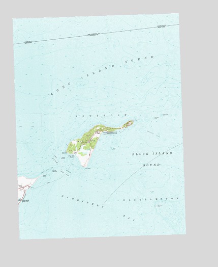
Plum Island, NY USGS Topographic Map
Click on map above to begin viewing in our Map Viewer.

This topographic map contains these locations and features:
Feature Name Type Latitude Longitude GNIS ID View Map
Battery Bogardus Eldridge (historical)MilitaryN41.1689°W72.1961°2090448View Map
Battery Bradford (historical)MilitaryN41.1894°W72.1633°2090449View Map
Battery Edmund Smith (historical)MilitaryN41.1414°W72.1458°2090453View Map
Battery Henry Campbell (historical)MilitaryN41.1897°W72.1617°2090455View Map
Battery James Dalliba (historical)MilitaryN41.1886°W72.1622°2090458View Map
Battery John Greble (historical)MilitaryN41.1892°W72.1656°2090459View Map
Battery Justin Dimick (historical)MilitaryN41.1886°W72.1639°2090460View Map
Battery Kelly (historical)MilitaryN41.1883°W72.1644°2090461View Map
Battery Peter Hagner (historical)MilitaryN41.1711°W72.2036°2090465View Map
Battery Robert Floyd (historical)MilitaryN41.1678°W72.1972°2090464View Map
Battery Steele (historical)MilitaryN41.1850°W72.1808°2090466View Map
Battery Stoneman (historical)MilitaryN41.1889°W72.1647°2090467View Map
Bedford ReefBarN41.1820°W72.1456°943493View Map
East PointCapeN41.1898°W72.1623°949212View Map
Fort Terry (historical)MilitaryN41.1800°W72.1950°2090472View Map
Fort Tyler (historical)MilitaryN41.1411°W72.1458°2090473View Map
Gardiners PointIslandN41.1415°W72.1456°974214View Map
Gardiners Point Island Lighthouse (historical)BuildingN41.1414°W72.1457°2486128View Map
Latham CemeteryCemeteryN41.1539°W72.2485°955068View Map
Middle GroundBarN41.1707°W72.2145°957102View Map
Middle Shoal RockBarN41.1929°W72.1404°957139View Map
Midway ShoalBarN41.1615°W72.2140°957166View Map
Old Silas RockBarN41.1915°W72.1456°959319View Map
Orient PointCapeN41.1604°W72.2337°959475View Map
Orient Point LighthouseLocaleN41.1634°W72.2237°959477View Map
Oyster Pond ReefBarN41.1626°W72.2276°959722View Map
Pine PointCapeN41.1651°W72.1987°960535View Map
Plum GutChannelN41.1659°W72.2156°960762View Map
Plum Gut HarborBayN41.1709°W72.2087°960763View Map
Plum IslandIslandN41.1809°W72.1934°960764View Map
Plum Island LighthouseBuildingN41.1737°W72.2115°960765View Map
Plum Island RockBarN41.1748°W72.1784°960766View Map
The SluicewayChannelN41.1954°W72.1417°971931View Map
United States Department of AgricultureLocaleN41.1843°W72.1881°975711View Map

Note: Coordinates in the location and feature list above are referenced to NAD83 datum.


Copyright (C) 2008-2024 Ryan Niemi / Sunset Dynamics ... All Rights Reserved