TopoQuest Logo
Do you find TopoQuest useful?
Help keep TopoQuest running and adding new maps/features by donating!
Bitcoin:  19c7KJd3qBynnjoSw5npx9KScwjBe4ifkT
Litecoin:  LXs6TkuXGGXo1vDsWCkWVdjQX94eUKd6ui
Home View Maps Find Maps Find Places Resources & Links


Point Cedar, Arkansas Topographic Map

USGS Map Title: Point Cedar, AR
USGS Map MRC: 34093C3
DRG (GeoTIFF) Download: o34093c3.tif


Neighboring USGS Topographic Map Quads:


  Bonnerdale, AR  
34093D4
 

  Pearcy, AR  
34093D3
 

  Hempwallace, AR  
34093D2
 

  Amity, AR  
34093C4
 

  Point Cedar, AR  
34093C3
 

  Bismarck, AR  
34093C2
 

  Chalybeate Mountain West, AR  
34093B4
 

  Chalybeate Mountain East, AR  
34093B3
 

  De Gray, AR  
34093B2


Map MRC Location:

N35°
W94°
N35°
W93°
H8 H7 H6 H5 H4 H3 H2 H1
G8 G7 G6 G5 G4 G3 G2 G1
F8 F7 F6 F5 F4 F3 F2 F1
E8 E7 E6 E5 E4 E3 E2 E1
D8 D7 D6 D5 D4 D3 D2 D1
C8 C7 C6 C5 C4 C3 C2 C1
B8 B7 B6 B5 B4 B3 B2 B1
A8 A7 A6 A5 A4 A3 A2 A1
N34°
W94°
N34°
W93°

Point Cedar, AR USGS 1:24K Topographic Map Preview:
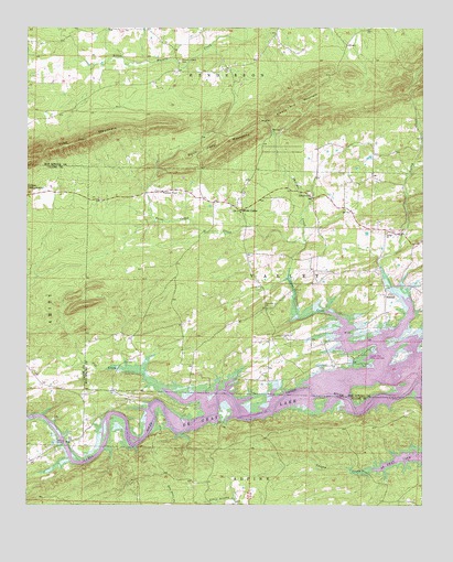
Point Cedar, AR USGS Topographic Map
Click on map above to begin viewing in our Map Viewer.

This topographic map contains these locations and features:
Feature Name Type Latitude Longitude GNIS ID View Map
Amity Landing Recreation AreaParkN34.2626°W93.3555°65003View Map
BeatonPopulated PlaceN34.3054°W93.2616°57350View Map
Cox CreekStreamN34.2807°W93.3324°48127View Map
Cox Creek Landing Recreation AreaParkN34.2770°W93.3210°75277View Map
Emory Mill MountainRidgeN34.3559°W93.2888°48895View Map
Free Hill CemeteryCemeteryN34.3020°W93.2988°66100View Map
Free Hill ChurchChurchN34.3015°W93.2993°49230View Map
Mazarn Chapel CemeteryCemeteryN34.3665°W93.3274°51771View Map
Philippi ChurchChurchN34.3315°W93.2857°53326View Map
Philippi CreekStreamN34.3184°W93.2874°53327View Map
Point CedarPopulated PlaceN34.3276°W93.3074°53639View Map
Point Cedar CreekStreamN34.2931°W93.2652°53640View Map
Point Cedar MountainsRidgeN34.3445°W93.3099°53641View Map
Point Cedar Picinic AreaParkN34.2801°W93.2946°66132View Map
Point Cedar United Methodist ChurchChurchN34.3268°W93.3077°66133View Map
Point Cedar Volunteer Fire StationBuildingN34.3307°W93.3003°2116992View Map
Shouse Ford Public Use AreaParkN34.2895°W93.2680°78359View Map
Township of Alpine (historical)CivilN34.2515°W93.3016°67186View Map
Township of HendersonCivilN34.3716°W93.3328°66662View Map
Township of ValleyCivilN34.3171°W93.3011°66670View Map
Trap MountainRidgeN34.3448°W93.3594°73888View Map
Valley CemeteryCemeteryN34.3212°W93.2602°75287View Map
Valley ChurchChurchN34.3215°W93.2613°55873View Map
Valley CreekStreamN34.2865°W93.2630°55874View Map
Wayside (historical)Populated PlaceN34.3515°W93.3118°66145View Map
Wesleyan ChapelChurchN34.3323°W93.3324°56159View Map
Yancey CreekStreamN34.2593°W93.2660°56579View Map

Note: Coordinates in the location and feature list above are referenced to NAD83 datum.


Copyright (C) 2008-2025 Ryan Niemi / Sunset Dynamics ... All Rights Reserved