TopoQuest Logo
Do you find TopoQuest useful?
Help keep TopoQuest running and adding new maps/features by donating!
Bitcoin:  19c7KJd3qBynnjoSw5npx9KScwjBe4ifkT
Litecoin:  LXs6TkuXGGXo1vDsWCkWVdjQX94eUKd6ui
Home View Maps Find Maps Find Places Resources & Links


Point Comfort, Texas Topographic Map

USGS Map Title: Point Comfort, TX
USGS Map MRC: 28096F5
DRG (GeoTIFF) Download: o28096f5.tif


Neighboring USGS Topographic Map Quads:


  La Salle, TX  
28096G6
 

  Lolita, TX  
28096G5
 

  La Ward, TX  
28096G4
 

  Kamey, TX  
28096F6
 

  Point Comfort, TX  
28096F5
 

  Olivia, TX  
28096F4
 

  Port Lavaca West, TX  
28096E6
 

  Port Lavaca East, TX  
28096E5
 

  Keller Bay, TX  
28096E4


Map MRC Location:

N29°
W97°
N29°
W96°
H8 H7 H6 H5 H4 H3 H2 H1
G8 G7 G6 G5 G4 G3 G2 G1
F8 F7 F6 F5 F4 F3 F2 F1
E8 E7 E6 E5 E4 E3 E2 E1
D8 D7 D6 D5 D4 D3 D2 D1
C8 C7 C6 C5 C4 C3 C2 C1
B8 B7 B6 B5 B4 B3 B2 B1
A8 A7 A6 A5 A4 A3 A2 A1
N28°
W97°
N28°
W96°

Point Comfort, TX USGS 1:24K Topographic Map Preview:
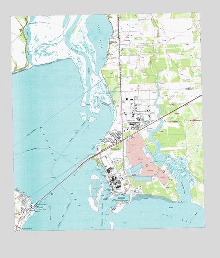
Point Comfort, TX USGS Topographic Map
Click on map above to begin viewing in our Map Viewer.

This topographic map contains these locations and features:
Feature Name Type Latitude Longitude GNIS ID View Map
Catfish BayouChannelN28.7058°W96.5625°1372973View Map
City of Point ComfortCivilN28.6715°W96.5591°2411451View Map
Clear LakeReservoirN28.6573°W96.5445°1863785View Map
Clear Lake LeveeDamN28.6569°W96.5436°1863784View Map
Cox BayBayN28.6306°W96.5194°1355241View Map
Cox CreekStreamN28.6528°W96.5155°1359808View Map
Cox PointCapeN28.6406°W96.5178°1355257View Map
Coxs Creek DamDamN28.6637°W96.5257°1861508View Map
Coxs Creek ReservoirReservoirN28.6653°W96.5297°1861509View Map
Dredge Spoil LakeReservoirN28.6549°W96.5271°1863791View Map
Dredge Spoil Lake LeveeDamN28.6586°W96.5253°1863790View Map
Evaporation LakeReservoirN28.6653°W96.5297°1863787View Map
Evaporation Lake DamDamN28.6669°W96.5336°1863786View Map
Evaporation Lake Number 1ReservoirN28.6636°W96.5319°1863777View Map
Evaporation Lake Number 1 LeveeDamN28.6636°W96.5319°1863776View Map
Evaporation Lake Number 2ReservoirN28.6636°W96.5336°1863779View Map
Evaporation Lake Number 2 LeveeDamN28.6636°W96.5336°1863778View Map
Evaporation Lake Number 3ReservoirN28.6669°W96.5369°1863781View Map
Evaporation Lake Number 3 LeveeDamN28.6669°W96.5369°1863780View Map
Fishing Pier ParkParkN28.6356°W96.6139°2028354View Map
Huisache CoveBarN28.6472°W96.5130°1359807View Map
Lavaca BayBayN28.6600°W96.5947°1360981View Map
Lavaca Causeway MarinaLocaleN28.6394°W96.6125°2030461View Map
Lavaca RiverStreamN28.6972°W96.5755°1374489View Map
Mud Lake Number 4ReservoirN28.6661°W96.5425°1863783View Map
Mud Lake Number 4 LeveeDamN28.6669°W96.5403°1863782View Map
Noble PointCapeN28.6375°W96.6111°1363944View Map
Point ComfortCapeN28.6431°W96.5633°1365499View Map
Point ComfortPopulated PlaceN28.6797°W96.5603°1365500View Map
Point Comfort City HallBuildingN28.6771°W96.5551°2753162View Map
Point Comfort Police DepartmentBuildingN28.6771°W96.5551°2335005View Map
Point Comfort Volunteer Fire DepartmentBuildingN28.6773°W96.5548°2552280View Map
Port Comfort Elementary SchoolSchoolN28.6777°W96.5575°2434338View Map
Raw Water LakeReservoirN28.6607°W96.5444°1861511View Map
Raw Water Lake LeveeDamN28.6619°W96.5436°1861510View Map
Smugglers BayouBayN28.7339°W96.6000°1368524View Map
Storm LakeReservoirN28.6581°W96.5496°1863789View Map
Storm Lake LeveeDamN28.6569°W96.5486°1863788View Map
Swam Lake Oil FieldOilfieldN28.7330°W96.5447°1369441View Map
Swan LakeLakeN28.7370°W96.5669°1369444View Map
Venado LakesLakeN28.7465°W96.6084°1370615View Map

Note: Coordinates in the location and feature list above are referenced to NAD83 datum.


Copyright (C) 2008-2025 Ryan Niemi / Sunset Dynamics ... All Rights Reserved