TopoQuest Logo
Do you find TopoQuest useful?
Help keep TopoQuest running and adding new maps/features by donating!
Bitcoin:  19c7KJd3qBynnjoSw5npx9KScwjBe4ifkT
Litecoin:  LXs6TkuXGGXo1vDsWCkWVdjQX94eUKd6ui
Home View Maps Find Maps Find Places Resources & Links


Point No Point, Maryland Topographic Map

USGS Map Title: Point No Point, MD
USGS Map MRC: 38076B3
DRG (GeoTIFF) Download: o38076b3.tif


Neighboring USGS Topographic Map Quads:


  Solomons Island, MD  
38076C4


  St. Marys City, MD  
38076B4
 

  Point No Point, MD  
38076B3


  Saint George Island, MD  
38076A4
 

  Point Lookout, MD  
38076A3
 

  Chesapeake Bay 3 (All Water), MD  
38076A2


Map MRC Location:

N39°
W77°
N39°
W76°
H8 H7 H6 H5 H4 H3 H2 H1
G8 G7 G6 G5 G4 G3 G2 G1
F8 F7 F6 F5 F4 F3 F2 F1
E8 E7 E6 E5 E4 E3 E2 E1
D8 D7 D6 D5 D4 D3 D2 D1
C8 C7 C6 C5 C4 C3 C2 C1
B8 B7 B6 B5 B4 B3 B2 B1
A8 A7 A6 A5 A4 A3 A2 A1
N38°
W77°
N38°
W76°

Point No Point, MD USGS 1:24K Topographic Map Preview:
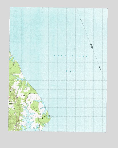
Point No Point, MD USGS Topographic Map
Click on map above to begin viewing in our Map Viewer.

This topographic map contains these locations and features:
Feature Name Type Latitude Longitude GNIS ID View Map
Bay ForestPopulated PlaceN38.1871°W76.3608°1697771View Map
Biscoe PondLakeN38.1962°W76.3692°594594View Map
Blue Gull HillSummitN38.1301°W76.3716°594596View Map
Carroll PondLakeN38.1768°W76.3565°594633View Map
DameronPopulated PlaceN38.1523°W76.3694°594687View Map
Dameron HouseBuildingN38.1621°W76.3513°1697786View Map
Dameron Post OfficePost OfficeN38.1526°W76.3698°1697787View Map
Elms BeachPopulated PlaceN38.1912°W76.3627°1697790View Map
Filbert PondLakeN38.1398°W76.3234°594706View Map
Fishers PointCapeN38.1276°W76.3452°598321View Map
Howleys ManorLocaleN38.1282°W76.3444°1697805View Map
Malone BayBayN38.1279°W76.3380°594813View Map
Peters PondLakeN38.1320°W76.3285°594872View Map
Point No PointCapeN38.1379°W76.3211°594883View Map
Saint Clarence CreekBayN38.1507°W76.3288°594913View Map
Saint Jerome BeachBeachN38.1307°W76.3352°594931View Map
Saint Jerome CreekBayN38.1329°W76.3488°594932View Map
Saint Jerome NeckCapeN38.1426°W76.3327°594933View Map
Saint Jerome ShoresPopulated PlaceN38.1293°W76.3330°1697845View Map
Saint Jeromes LandingPopulated PlaceN38.1340°W76.3544°1697846View Map
Saint Jeromes ManorLocaleN38.1298°W76.3305°1697847View Map
Taylor CoveBayN38.1276°W76.3549°594979View Map
Wingfield AirportAirportN38.1434°W76.3576°598352View Map

Note: Coordinates in the location and feature list above are referenced to NAD83 datum.


Copyright (C) 2008-2024 Ryan Niemi / Sunset Dynamics ... All Rights Reserved