TopoQuest Logo
Do you find TopoQuest useful?
Help keep TopoQuest running and adding new maps/features by donating!
Bitcoin:  19c7KJd3qBynnjoSw5npx9KScwjBe4ifkT
Litecoin:  LXs6TkuXGGXo1vDsWCkWVdjQX94eUKd6ui
Home View Maps Find Maps Find Places Resources & Links


Pollocksville, North Carolina Topographic Map

USGS Map Title: Pollocksville, NC
USGS Map MRC: 35077A2
DRG (GeoTIFF) Download: o35077a2.tif


Neighboring USGS Topographic Map Quads:


  Cove City, NC  
35077B3
 

  Jasper, NC  
35077B2
 

  Askin, NC  
35077B1
 

  Trenton, NC  
35077A3
 

  Pollocksville, NC  
35077A2
 

  New Bern, NC  
35077A1
 

  Jacksonville NE, NC  
34077H3
 

  Maysville, NC  
34077H2
 

  Catfish Lake, NC  
34077H1


Map MRC Location:

N36°
W78°
N36°
W77°
H8 H7 H6 H5 H4 H3 H2 H1
G8 G7 G6 G5 G4 G3 G2 G1
F8 F7 F6 F5 F4 F3 F2 F1
E8 E7 E6 E5 E4 E3 E2 E1
D8 D7 D6 D5 D4 D3 D2 D1
C8 C7 C6 C5 C4 C3 C2 C1
B8 B7 B6 B5 B4 B3 B2 B1
A8 A7 A6 A5 A4 A3 A2 A1
N35°
W78°
N35°
W77°

Pollocksville, NC USGS 1:24K Topographic Map Preview:
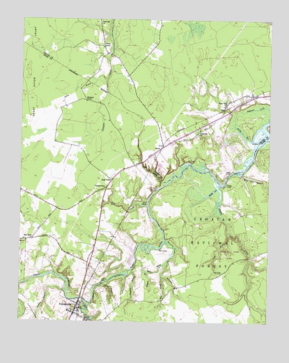
Pollocksville, NC USGS Topographic Map
Click on map above to begin viewing in our Map Viewer.

This topographic map contains these locations and features:
Feature Name Type Latitude Longitude GNIS ID View Map
Beaver BranchStreamN35.0240°W77.1772°1009070View Map
Bells LandingLocaleN35.0302°W77.1794°1019077View Map
Canaan Air BaseAirportN35.0871°W77.1625°1016907View Map
Clayhill BranchStreamN35.0215°W77.1936°1010305View Map
Debruhls LandingPopulated PlaceN35.0557°W77.1808°1019933View Map
Deep GullyValleyN35.0582°W77.1787°1010762View Map
Goshen BranchStreamN35.0129°W77.2258°1011569View Map
Hayward CreekStreamN35.0788°W77.1258°1011940View Map
Hollis BranchStreamN35.1010°W77.2066°1012133View Map
Island CreekStreamN35.0568°W77.1497°1012378View Map
Island Creek Fire TowerTowerN35.0207°W77.1477°1023647View Map
Jones CornerPopulated PlaceN35.0588°W77.2041°1020978View Map
Long BranchStreamN35.0371°W77.1447°1013093View Map
Mill CreekStreamN35.0077°W77.2141°1025534View Map
Miry Hole BranchStreamN35.0618°W77.1388°1013626View Map
Muddy CoveBayN35.0546°W77.1525°1013822View Map
Oak GrovePopulated PlaceN35.0340°W77.2436°1014049View Map
PollocksvillePopulated PlaceN35.0060°W77.2211°1014565View Map
Pollocksville Elementary SchoolSchoolN35.0048°W77.2254°1017586View Map
Pollocksville Police DepartmentBuildingN35.0068°W77.2235°2130872View Map
Pollocksville Post OfficePost OfficeN35.0080°W77.2196°2766597View Map
Pollocksville Rescue SquadBuildingN35.0067°W77.2234°2720659View Map
Pollocksville Volunteer Fire DepartmentBuildingN35.0068°W77.2234°2638177View Map
Raccoon CreekStreamN35.0335°W77.1766°1014701View Map
RhemsPopulated PlaceN35.0727°W77.1780°1022235View Map
Rhems LandingLocaleN35.0618°W77.1444°1022236View Map
Rhems Volunteer Fire DepartmentBuildingN35.0761°W77.1513°2638333View Map
Rhems Volunteer Fire DepartmentBuildingN35.0717°W77.1809°2638590View Map
River BendPopulated PlaceN35.0690°W77.1469°1017440View Map
River Bend Police DepartmentBuildingN35.0728°W77.1485°2130991View Map
River Bend Wastewater Treatment PlantLocaleN35.0705°W77.1351°2506016View Map
Rocky RunStreamN35.0807°W77.1286°1015054View Map
Rocky Run ChurchChurchN35.0907°W77.1466°1015055View Map
Rocky Run SchoolSchoolN35.0790°W77.1602°1015056View Map
Scott CreekStreamN35.0482°W77.1858°1015334View Map
Scott LandingLocaleN35.0493°W77.1861°1022522View Map
Simmons CornerPopulated PlaceN35.0915°W77.2172°1015540View Map
Skinners BranchStreamN35.0210°W77.1855°1015564View Map
Spoil BankLeveeN35.0182°W77.2008°1017985View Map
Tar LandingLocaleN35.0665°W77.1650°1022884View Map
Taylor LandingAreaN35.0349°W77.1766°1017583View Map
Tenmile ForkPopulated PlaceN35.0563°W77.2061°1022904View Map
Town of PollocksvilleCivilN35.0056°W77.2211°2407143View Map
Town of River BendCivilN35.0717°W77.1504°2407222View Map
Township 2-PollocksvilleCivilN35.0111°W77.2085°1026861View Map
Trent BridgeBridgeN35.0099°W77.2191°1008026View Map
Virgil Hill ChurchChurchN35.1240°W77.2102°1016380View Map
Wesley ChapelChurchN35.1149°W77.2091°1016509View Map
West BranchStreamN35.0160°W77.2072°1016520View Map
West Prong Raccoon CreekStreamN35.0238°W77.1769°1016552View Map
White Rock LandingLocaleN35.0527°W77.1830°1017582View Map
WhitfordLocaleN35.0457°W77.1386°1017585View Map
Whitford LandingLocaleN35.0574°W77.1463°1023227View Map

Note: Coordinates in the location and feature list above are referenced to NAD83 datum.


Copyright (C) 2008-2025 Ryan Niemi / Sunset Dynamics ... All Rights Reserved