TopoQuest Logo
Do you find TopoQuest useful?
Help keep TopoQuest running and adding new maps/features by donating!
Bitcoin:  19c7KJd3qBynnjoSw5npx9KScwjBe4ifkT
Litecoin:  LXs6TkuXGGXo1vDsWCkWVdjQX94eUKd6ui
Home View Maps Find Maps Find Places Resources & Links


Porter Mountain, Colorado Topographic Map

USGS Map Title: Porter Mountain, CO
USGS Map MRC: 39107B6
DRG (GeoTIFF) Download: o39107b6.tif


Neighboring USGS Topographic Map Quads:


  South Mamm Peak, CO  
39107C7
 

  Hightower Mountain, CO  
39107C6
 

  Flatiron Mountain, CO  
39107C5
 

  Vega Reservoir, CO  
39107B7
 

  Porter Mountain, CO  
39107B6
 

  Spruce Mountain, CO  
39107B5
 

  Leon Peak, CO  
39107A7
 

  Chalk Mountain, CO  
39107A6
 

  Electric Mountain, CO  
39107A5


Map MRC Location:

N40°
W108°
N40°
W107°
H8 H7 H6 H5 H4 H3 H2 H1
G8 G7 G6 G5 G4 G3 G2 G1
F8 F7 F6 F5 F4 F3 F2 F1
E8 E7 E6 E5 E4 E3 E2 E1
D8 D7 D6 D5 D4 D3 D2 D1
C8 C7 C6 C5 C4 C3 C2 C1
B8 B7 B6 B5 B4 B3 B2 B1
A8 A7 A6 A5 A4 A3 A2 A1
N39°
W108°
N39°
W107°

Porter Mountain, CO USGS 1:24K Topographic Map Preview:
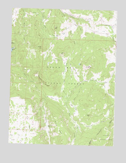
Porter Mountain, CO USGS Topographic Map
Click on map above to begin viewing in our Map Viewer.

This topographic map contains these locations and features:
Feature Name Type Latitude Longitude GNIS ID View Map
Baldridge PointSummitN39.2141°W107.7142°175111View Map
Bear Den DitchCanalN39.2447°W107.7126°202297View Map
Bronco KnobSummitN39.1528°W107.6548°175095View Map
Bull Elk DitchCanalN39.1700°W107.6837°175098View Map
Buzzard ParkFlatN39.1430°W107.6531°175094View Map
Carnahan Ditch Number 1CanalN39.2478°W107.7373°169483View Map
Castle CreekStreamN39.2466°W107.6909°175116View Map
Castle DitchCanalN39.2339°W107.7151°175118View Map
Dead Mare ParkFlatN39.1916°W107.6714°175106View Map
Deep Creek MineMineN39.1416°W107.7006°1684117View Map
East Porter CreekStreamN39.2058°W107.6803°175103View Map
Elizabethe DitchCanalN39.2030°W107.6909°175109View Map
Elk LakeLakeN39.1997°W107.6684°175107View Map
Gander PondLakeN39.2246°W107.6977°175114View Map
Grass ParkFlatN39.1936°W107.7312°175101View Map
Hanson DrawValleyN39.2375°W107.6764°175117View Map
High TrailTrailN39.1369°W107.7212°202294View Map
Lenna PeakSummitN39.2325°W107.6984°175113View Map
Lowell FlatFlatN39.2305°W107.6448°175119View Map
McKelvie ReservoirReservoirN39.2105°W107.7488°202293View Map
Owens CreekStreamN39.2353°W107.6326°174929View Map
Owens Creek CorralLocaleN39.2347°W107.6306°197466View Map
Plateau ParkFlatN39.1672°W107.6970°175097View Map
Plateau RidgeRidgeN39.1897°W107.7195°175100View Map
Porter CreekStreamN39.2441°W107.6823°175104View Map
Porter FlatFlatN39.2025°W107.6851°175105View Map
Porter MountainSummitN39.1975°W107.6587°175108View Map
Silver Spruce TrailTrailN39.2405°W107.7084°202291View Map
Steep CreekStreamN39.1594°W107.7109°175099View Map
Stillwater ParkFlatN39.1419°W107.7020°175093View Map
Stubb CreekStreamN39.2350°W107.6789°175115View Map
The Flat TopsSummitN39.1347°W107.7217°202290View Map
Two PeakSummitN39.2097°W107.6878°175110View Map
Wagon ParkFlatN39.1597°W107.6728°175096View Map
Walt CreekStreamN39.1828°W107.6359°175112View Map
West Porter CreekStreamN39.2058°W107.6803°175102View Map
Willow RidgeRidgeN39.1261°W107.6878°202296View Map

Note: Coordinates in the location and feature list above are referenced to NAD83 datum.


Copyright (C) 2008-2024 Ryan Niemi / Sunset Dynamics ... All Rights Reserved