TopoQuest Logo
Do you find TopoQuest useful?
Help keep TopoQuest running and adding new maps/features by donating!
Bitcoin:  19c7KJd3qBynnjoSw5npx9KScwjBe4ifkT
Litecoin:  LXs6TkuXGGXo1vDsWCkWVdjQX94eUKd6ui
Home View Maps Find Maps Find Places Resources & Links


Portsmouth, North Carolina Topographic Map

USGS Map Title: Portsmouth, NC
USGS Map MRC: 35076A1
DRG (GeoTIFF) Download: o35076a1.tif


Neighboring USGS Topographic Map Quads:


  Howard Reef, NC  
35075B8


  Portsmouth, NC  
35076A1
 

  Ocracoke, NC  
35075A8


Map MRC Location:

N36°
W77°
N36°
W76°
H8 H7 H6 H5 H4 H3 H2 H1
G8 G7 G6 G5 G4 G3 G2 G1
F8 F7 F6 F5 F4 F3 F2 F1
E8 E7 E6 E5 E4 E3 E2 E1
D8 D7 D6 D5 D4 D3 D2 D1
C8 C7 C6 C5 C4 C3 C2 C1
B8 B7 B6 B5 B4 B3 B2 B1
A8 A7 A6 A5 A4 A3 A2 A1
N35°
W77°
N35°
W76°

Portsmouth, NC USGS 1:24K Topographic Map Preview:
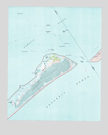
Portsmouth, NC USGS Topographic Map
Click on map above to begin viewing in our Map Viewer.

This topographic map contains these locations and features:
Feature Name Type Latitude Longitude GNIS ID View Map
Amity Shoal (historical)BarN35.0571°W76.0268°1018686View Map
Ayers RockPillarN35.0866°W76.0699°1008341View Map
Babb-Dixon CemeteryCemeteryN35.0713°W76.0616°1002775View Map
Bay Marsh (historical)SwampN35.0696°W76.0741°1002787View Map
Baymarsh ThorofareGutN35.0677°W76.0705°980666View Map
Beacon IslandIslandN35.0982°W76.0468°980679View Map
Beacon Island RoadsIslandN35.0985°W76.0455°1002789View Map
Blair ChannelBayN35.0891°W76.0413°1023377View Map
Casey BayBayN35.0660°W76.0738°982726View Map
Casey IslandIslandN35.0774°W76.0677°982728View Map
Community CemeteryCemeteryN35.0704°W76.0652°1002772View Map
Daniel SwashBayN35.0341°W76.1027°983940View Map
Evergreen IslandIslandN35.0574°W76.0766°984881View Map
Evergreen SloughGutN35.0613°W76.0746°984885View Map
Ferry LandingLocaleN35.0724°W76.0627°1002770View Map
Flounder RockBarN35.1002°W76.0955°1023378View Map
Haulover PointCapeN35.0729°W76.0646°986500View Map
High Hills InletChannelN35.0196°W76.1152°986750View Map
Horse Island ChannelChannelN35.0752°W76.0552°1002792View Map
Life Saving Service Station (historical)BuildingN35.0702°W76.0607°1002773View Map
Methodist ChurchChurchN35.0704°W76.0621°1002774View Map
Mount Vernon RockBarN35.0793°W76.0968°1023699View Map
North RockIslandN35.1057°W76.0718°991268View Map
Ocracoke InletChannelN35.0641°W76.0160°991514View Map
Oyster RocksBarN35.0891°W76.0580°1002795View Map
PortsmouthPopulated PlaceN35.0696°W76.0638°1022050View Map
Portsmouth IslandIslandN35.0485°W76.0724°992730View Map
Portsmouth VillagePopulated PlaceN35.0685°W76.0635°1002761View Map
Portsmouth Village Ranger StationLocaleN35.0710°W76.0632°1002777View Map
Royal PointCapeN35.0527°W76.0874°993789View Map
Royal Point BayBayN35.0532°W76.0855°993790View Map
SchoolhouseSchoolN35.0685°W76.0680°1002776View Map
Sheep IslandIslandN35.0694°W76.0722°994614View Map
Sheep Island Slue LightTowerN35.0754°W76.1055°994616View Map
Sheep Island Slue LightTowerN35.0818°W76.0560°994617View Map
Shell CastleIslandN35.0977°W76.0685°994635View Map
The HauloverGutN35.0549°W76.0810°995981View Map
The High HillsIslandN35.0207°W76.1110°995982View Map
Vera Cruz ShoalBarN35.0663°W76.0249°996606View Map
Wallace ChannelChannelN35.0877°W76.0468°1002782View Map
Wallace Channel BeaconTowerN35.0849°W76.0493°996719View Map
Wallace Channel LightTowerN35.0721°W76.0468°996720View Map
Wallace Channel LightTowerN35.1171°W76.1124°996721View Map
Warren Gilgos CreekGutN35.0682°W76.0691°1002786View Map
Whalebone InletGutN35.0174°W76.1143°1002788View Map
Whalebone IslandIslandN35.0193°W76.1171°997096View Map

Note: Coordinates in the location and feature list above are referenced to NAD83 datum.


Copyright (C) 2008-2024 Ryan Niemi / Sunset Dynamics ... All Rights Reserved