TopoQuest Logo
Do you find TopoQuest useful?
Help keep TopoQuest running and adding new maps/features by donating!
Bitcoin:  19c7KJd3qBynnjoSw5npx9KScwjBe4ifkT
Litecoin:  LXs6TkuXGGXo1vDsWCkWVdjQX94eUKd6ui
Home View Maps Find Maps Find Places Resources & Links


Big Basin, California Topographic Map

USGS Map Title: Big Basin, CA
USGS Map MRC: 37122B2
DRG (GeoTIFF) Download: o37122b2.tif


Neighboring USGS Topographic Map Quads:


  La Honda, CA  
37122C3
 

  Mindego Hill, CA  
37122C2
 

  Cupertino, CA  
37122C1
 

  Franklin Point, CA  
37122B3
 

  Big Basin, CA  
37122B2
 

  Castle Rock Ridge, CA  
37122B1
 

  Point Ano Nuevo, CA  
37122A3
 

  Davenport, CA  
37122A2
 

  Felton, CA  
37122A1


Map MRC Location:

N38°
W123°
N38°
W122°
H8 H7 H6 H5 H4 H3 H2 H1
G8 G7 G6 G5 G4 G3 G2 G1
F8 F7 F6 F5 F4 F3 F2 F1
E8 E7 E6 E5 E4 E3 E2 E1
D8 D7 D6 D5 D4 D3 D2 D1
C8 C7 C6 C5 C4 C3 C2 C1
B8 B7 B6 B5 B4 B3 B2 B1
A8 A7 A6 A5 A4 A3 A2 A1
N37°
W123°
N37°
W122°

Big Basin, CA USGS 1:24K Topographic Map Preview:
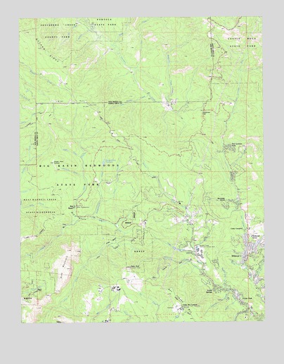
Big Basin, CA USGS Topographic Map
Click on map above to begin viewing in our Map Viewer.

This topographic map contains these locations and features:
Feature Name Type Latitude Longitude GNIS ID View Map
Basin TrailTrailN37.2077°W122.2094°1872633View Map
Ben Lomond MountainSummitN37.1311°W122.1680°219029View Map
Ben Lomond Youth Conservation CampSchoolN37.1304°W122.1689°2504423View Map
Big BasinBasinN37.1674°W122.2225°219126View Map
Big Basin Post OfficePost OfficeN37.1724°W122.2219°1662288View Map
Big Basin Redwoods State ParkParkN37.1852°W122.2297°233497View Map
Big Basin Redwoods State Park HeadquartersLocaleN37.1724°W122.2216°1872636View Map
Blooms CreekStreamN37.1652°W122.2250°219471View Map
Blooms Creek CampgroundLocaleN37.1680°W122.2180°1872637View Map
Blooms Creek TrailTrailN37.1669°W122.2200°1872638View Map
Boulder Creek Census Designated PlaceCensusN37.1341°W122.1272°2407892View Map
Boulder Creek Fire Protection District SubstationBuildingN37.1460°W122.1585°2624050View Map
Boulder Creek Golf and Country ClubLocaleN37.1536°W122.1594°219692View Map
Bracken BraePopulated PlaceN37.1394°W122.1439°1872641View Map
Bracken Brae CreekStreamN37.1388°W122.1455°219754View Map
Bulls SpringSpringN37.2011°W122.1977°1872643View Map
Butano RidgeRidgeN37.2299°W122.2282°220268View Map
Butano Ridge Loop TrailTrailN37.2436°W122.2300°1786317View Map
Buzzards RoostSummitN37.1547°W122.2269°1872644View Map
Camp Ben LomondLocaleN37.1308°W122.1694°220442View Map
Camp CampbellLocaleN37.1630°W122.1369°220445View Map
Circle Group CampLocaleN37.2494°W122.2147°1786321View Map
Creeping Forest TrailTrailN37.1805°W122.2239°1872646View Map
Dool TrailTrailN37.1761°W122.2291°1872649View Map
Eagle RockSummitN37.1474°W122.1950°222827View Map
Eagle Rock LookoutTowerN37.1474°W122.1952°1872650View Map
East Ridge TrailTrailN37.1647°W122.2047°1872651View Map
Fall CreekStreamN37.2494°W122.2177°223364View Map
Foreman CreekStreamN37.1302°W122.1336°223672View Map
Forest ParkPopulated PlaceN37.1338°W122.1386°1658562View Map
Forest SpringsPopulated PlaceN37.1388°W122.1489°1658563View Map
Forest Swimming PoolParkN37.1358°W122.1405°1872652View Map
Governors CampLocaleN37.1716°W122.2216°1872654View Map
Hare CreekStreamN37.1530°W122.1616°224931View Map
Hilton Airport (historical)AirportN37.1527°W122.1594°1872657View Map
Hollow Tree TrailTrailN37.2074°W122.2316°1872658View Map
Huckleberry CampgroundLocaleN37.1755°W122.2064°1872660View Map
Iverson CreekStreamN37.2458°W122.2139°226024View Map
Iverson TrailTrailN37.2469°W122.2166°1786333View Map
Jamison CreekStreamN37.1463°W122.1569°226139View Map
Jay Trail CampLocaleN37.1688°W122.2211°1872661View Map
Kings CreekStreamN37.1552°W122.1341°226601View Map
Lane Trail CampLocaleN37.2141°W122.2214°1872663View Map
Little BasinBasinN37.1577°W122.2033°227188View Map
Little Boulder CreekStreamN37.2186°W122.1852°227199View Map
Locatelli RanchLocaleN37.1422°W122.1958°227450View Map
Lockheed Martin Space Systems CompanyBuildingN37.1399°W122.2023°2624059View Map
Maddocks CreekStreamN37.1849°W122.2191°227903View Map
McAbee MountainSummitN37.1613°W122.2450°1872664View Map
Meteor TrailTrailN37.1952°W122.2261°1872666View Map
Mount McAbee OverlookLocaleN37.1605°W122.2433°1872668View Map
Oak Site 1-065 DamDamN37.1283°W122.1711°1663266View Map
Ocean Grove Charter SchoolSchoolN37.1683°W122.1350°2504468View Map
Ocean View SummitSummitN37.1908°W122.2341°229927View Map
Oil CreekStreamN37.2291°W122.1919°229945View Map
Opal CreekStreamN37.1649°W122.2250°230060View Map
Peavine CreekStreamN37.1380°W122.1430°230449View Map
Pine MountainSummitN37.1547°W122.2266°230707View Map
Pine Mountain TrailTrailN37.1597°W122.2247°1872669View Map
Portola TrailTrailN37.2449°W122.2241°1786344View Map
Redwood GrovePopulated PlaceN37.1574°W122.1341°1659489View Map
Redwood TrailTrailN37.1702°W122.2236°1872670View Map
Rices JunctionPopulated PlaceN37.1527°W122.1341°1702041View Map
Riverside GrovePopulated PlaceN37.1738°W122.1433°1659520View Map
Rogers CreekStreamN37.1924°W122.2191°231818View Map
San Lorenzo ParkPopulated PlaceN37.1961°W122.1455°232436View Map
Sempervirens 1-02 DamDamN37.1899°W122.2077°1663227View Map
Sempervirens CampgroundLocaleN37.1683°W122.2108°1872671View Map
Sempervirens CreekStreamN37.1674°W122.2133°232799View Map
Sempervirens ReservoirReservoirN37.1906°W122.2081°232800View Map
Sequoia Group CampLocaleN37.1747°W122.2183°1872672View Map
Sequoia TrailTrailN37.1752°W122.2114°1872673View Map
Shadowbrook TrailTrailN37.1741°W122.2100°1872674View Map
Silver CreekStreamN37.1336°W122.1405°233124View Map
Slate CreekStreamN37.2386°W122.2036°233236View Map
Spring CreekStreamN37.1480°W122.1366°235234View Map
Sunset TrailTrailN37.1838°W122.2425°1872677View Map
Two Bar CreekStreamN37.1422°W122.1325°236724View Map
Union CreekStreamN37.1749°W122.2089°236789View Map
Wastahi CampgroundLocaleN37.1761°W122.2102°1872680View Map
Waterman CreekStreamN37.2144°W122.1758°237336View Map
Waterman GapGapN37.2119°W122.1566°237338View Map
WildwoodPopulated PlaceN37.1513°W122.1361°1660180View Map

Note: Coordinates in the location and feature list above are referenced to NAD83 datum.


Copyright (C) 2008-2025 Ryan Niemi / Sunset Dynamics ... All Rights Reserved