TopoQuest Logo
Do you find TopoQuest useful?
Help keep TopoQuest running and adding new maps/features by donating!
Bitcoin:  19c7KJd3qBynnjoSw5npx9KScwjBe4ifkT
Litecoin:  LXs6TkuXGGXo1vDsWCkWVdjQX94eUKd6ui
Home View Maps Find Maps Find Places Resources & Links


Powersburg, Kentucky Topographic Map

USGS Map Title: Powersburg, KY
USGS Map MRC: 36084F8
DRG (GeoTIFF) Download: o36084f8.tif


Neighboring USGS Topographic Map Quads:


  Cumberland City, KY  
36085G1
 

  Parnell, KY  
36084G8
 

  Monticello, KY  
36084G7
 

  Savage, KY  
36085F1
 

  Powersburg, KY  
36084F8
 

  Parmleysville, KY  
36084F7
 

  Moodyville, TN  
36085E1
 

  Pall Mall, TN  
36084E8
 

  Sharp Place, TN  
36084E7


Map MRC Location:

N37°
W85°
N37°
W84°
H8 H7 H6 H5 H4 H3 H2 H1
G8 G7 G6 G5 G4 G3 G2 G1
F8 F7 F6 F5 F4 F3 F2 F1
E8 E7 E6 E5 E4 E3 E2 E1
D8 D7 D6 D5 D4 D3 D2 D1
C8 C7 C6 C5 C4 C3 C2 C1
B8 B7 B6 B5 B4 B3 B2 B1
A8 A7 A6 A5 A4 A3 A2 A1
N36°
W85°
N36°
W84°

Powersburg, KY USGS 1:24K Topographic Map Preview:
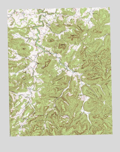
Powersburg, KY USGS Topographic Map
Click on map above to begin viewing in our Map Viewer.

This topographic map contains these locations and features:
Feature Name Type Latitude Longitude GNIS ID View Map
Bearpen HollowValleyN36.6340°W84.9560°486585View Map
Bens CliffCliffN36.6959°W84.9527°486871View Map
Bertram CemeteryCemeteryN36.6582°W84.9765°2569827View Map
Bertram HollowValleyN36.6582°W84.9760°486918View Map
Bills BluffCliffN36.7091°W84.9416°2569834View Map
Bridgeman MountainSummitN36.7134°W84.9347°487890View Map
Browns Mill (historical)LocaleN36.6869°W84.9202°2569844View Map
Buck GraveyardCemeteryN36.7167°W84.9789°2569846View Map
Buck KnobSummitN36.7109°W84.9805°488227View Map
Bucks CemeteryCemeteryN36.6776°W84.9122°488290View Map
Burris CemeteryCemeteryN36.7418°W84.9657°2569853View Map
Carey CemeteryCemeteryN36.7496°W84.9619°2569857View Map
Carpenter ForkStreamN36.7084°W84.9563°488961View Map
Catron CemeteryCemeteryN36.6665°W84.9766°489098View Map
Catron HollowValleyN36.6641°W84.9801°489101View Map
Charley Bridgeman Mill (historical)LocaleN36.7395°W84.9624°2569860View Map
Cherry Gap MountainSummitN36.6823°W84.8916°489402View Map
Chestnut Grove SchoolSchoolN36.6356°W84.9855°489444View Map
Chestnut Grove United Baptist ChurchChurchN36.6417°W84.9794°489435View Map
Chimney Rock RidgeRidgeN36.7218°W84.9221°2569861View Map
Covey CemeteryCemeteryN36.7289°W84.9805°2569870View Map
Dalton CemeteryCemeteryN36.6502°W84.9769°2569878View Map
Denney CemeteryCemeteryN36.7041°W84.9661°2569885View Map
Denney CemeteryCemeteryN36.7097°W84.9770°2569886View Map
Denney HollowValleyN36.6985°W84.9679°485678View Map
Denney Hollow SchoolSchoolN36.7026°W84.9791°490813View Map
Denver-Hoover-Tuggle CemeteryCemeteryN36.6976°W84.9674°2569887View Map
Devils KitchenLocaleN36.7454°W84.9855°2569888View Map
Dishman CemeteryCemeteryN36.6890°W84.9211°490900View Map
Dishman Mill (historical)LocaleN36.6771°W84.9113°2569889View Map
Double Head CreekStreamN36.7462°W84.9533°491043View Map
Doublehead SpringsSpringN36.7127°W84.8922°2569896View Map
Dry HollowValleyN36.6869°W84.9211°511934View Map
Dry Hollow SchoolSchoolN36.6612°W84.9416°491224View Map
Duncan Valley CemeteryCemeteryN36.7343°W84.8968°2569899View Map
Duncan Valley SchoolSchoolN36.7440°W84.8958°491310View Map
Edwards ChapelChurchN36.6956°W84.9655°491581View Map
Edwards MountainSummitN36.7173°W84.9086°491583View Map
Frost HollowValleyN36.7039°W84.9853°492578View Map
Gap Creek Mill (historical)LocaleN36.7437°W84.9955°2569918View Map
Gap Creek School (historical)SchoolN36.7422°W84.9973°2569919View Map
Gap Creek SpringSpringN36.7432°W84.9853°2569920View Map
GapcreekPopulated PlaceN36.7448°W84.9952°508064View Map
Gapcreek Post Office (historical)Post OfficeN36.7444°W84.9954°2569921View Map
Gingercake RidgeRidgeN36.6678°W84.8786°492863View Map
Goff Mill (historical)LocaleN36.7062°W84.9052°2569927View Map
Guffey MountainSummitN36.7187°W84.9472°493461View Map
Gum PondReservoirN36.6965°W84.9079°2569935View Map
Gum Pond CliffCliffN36.6736°W84.9378°2569936View Map
Hall HollowValleyN36.6417°W84.9539°493588View Map
Hancock SchoolSchoolN36.6873°W84.9783°493673View Map
Harmon HollowValleyN36.7373°W84.9583°493755View Map
Harrison RidgeRidgeN36.6648°W84.8897°493818View Map
Hicks MountainSummitN36.7065°W84.9996°2569946View Map
Hicks-Harmon CemeteryCemeteryN36.7415°W84.9719°2569947View Map
HidalgoPopulated PlaceN36.7356°W84.9474°508233View Map
Hidalgo Post Office (historical)Post OfficeN36.7348°W84.9500°2569948View Map
Hidalgo School (historical)SchoolN36.7348°W84.9496°2569949View Map
Hog HollowValleyN36.6911°W84.9293°494343View Map
Hog MountainSummitN36.6781°W84.9416°494347View Map
Hog RockLocaleN36.6589°W84.9983°2569951View Map
Horse CliffCliffN36.6370°W84.9764°2569952View Map
Horse Pound RidgeRidgeN36.6442°W84.9449°494590View Map
Horse RockLocaleN36.6504°W84.9968°2569953View Map
Huffaker-Bridgeman CemeteryCemeteryN36.6948°W84.9020°2569956View Map
Indian GraveyardCemeteryN36.6912°W84.9296°2569961View Map
Indian RockhouseLocaleN36.6945°W84.9298°2569962View Map
Jennings HollowValleyN36.7193°W84.9636°495209View Map
Jennings Hollow SchoolSchoolN36.7209°W84.9738°495210View Map
JimtownPopulated PlaceN36.6445°W84.9322°508345View Map
Keens ChapelChurchN36.7342°W84.9497°495595View Map
Kelsay CemeteryCemeteryN36.7168°W84.9907°2569977View Map
King Green CliffCliffN36.6970°W84.8772°2569982View Map
Lee Mill (historical)LocaleN36.7288°W84.9719°2569983View Map
Lone RockPillarN36.6912°W84.9574°497003View Map
Lone Rock MountainSummitN36.6955°W84.9672°2569986View Map
Lonerock Post Office (historical)Post OfficeN36.6878°W84.9883°2569987View Map
Long CliffCliffN36.6406°W84.9716°497090View Map
Low GapPopulated PlaceN36.6451°W84.9588°508512View Map
Lowe CemeteryCemeteryN36.6338°W84.8859°2569989View Map
Lucky Camp HollowValleyN36.6482°W84.9104°497334View Map
Manning Peercy CemeteryCemeteryN36.6780°W84.9583°2569998View Map
Massengale MountainSummitN36.7096°W84.9902°2570000View Map
Mill PointCliffN36.6906°W84.9105°498290View Map
Mitchell KnobSummitN36.6823°W84.9819°498451View Map
Morgan CemeteryCemeteryN36.6948°W84.9297°498585View Map
Mose PointLocaleN36.7422°W84.9394°2570008View Map
Mountain View Baptist CampLocaleN36.6856°W84.9036°2570013View Map
Mullberry HillSummitN36.7351°W84.9741°2570014View Map
Oil Well HoleLocaleN36.7055°W84.9412°2570023View Map
Peercy CemeteryCemeteryN36.6861°W84.9664°2570034View Map
Peercy HollowValleyN36.6717°W84.9729°2570035View Map
Perdue CemeteryCemeteryN36.7472°W84.9908°2570037View Map
Pleasant Hill ChurchChurchN36.6709°W84.9741°500847View Map
PowersburgPopulated PlaceN36.7042°W84.9652°501260View Map
Powersburg Elementary School (historical)SchoolN36.7074°W84.9596°2570044View Map
Powersburg Post Office (historical)Post OfficeN36.7070°W84.9644°2570045View Map
Pyles CemeteryCemeteryN36.6752°W84.9107°2570047View Map
Raines CemeteryCemeteryN36.7169°W84.9398°2570050View Map
Rains CemeteryCemeteryN36.6944°W84.9913°2570051View Map
Redmond CreekStreamN36.6626°W84.9058°514875View Map
Reuben Dishman Mill (historical)LocaleN36.6904°W84.9817°2570054View Map
Rice CemeteryCemeteryN36.6976°W84.8891°2570055View Map
Round CliffCliffN36.6334°W84.9669°502398View Map
Sand SpringsSpringN36.6436°W84.8983°2570059View Map
Sandy Valley SchoolSchoolN36.6651°W84.9099°502987View Map
Scotts CliffCliffN36.7220°W84.9199°503112View Map
Sheep RockPillarN36.6928°W84.9549°503309View Map
Sidwell CemeteryCemeteryN36.7054°W84.9235°2570067View Map
SlickfordPopulated PlaceN36.6876°W84.9205°509077View Map
Slickford Post Office (historical)Post OfficeN36.6754°W84.9123°2570072View Map
Slickford SchoolSchoolN36.6926°W84.9280°503684View Map
Slobaum WellWellN36.6547°W84.9455°2570075View Map
Stinson-Coil CemeteryCemeteryN36.7433°W84.9325°2570082View Map
SunnybrookPopulated PlaceN36.6578°W84.9758°504797View Map
Sunnybrook Post Office (historical)Post OfficeN36.6498°W84.9776°2570090View Map
Sunnybrook SchoolSchoolN36.6628°W84.9741°504798View Map
Sweet Gum HollowValleyN36.6392°W84.9583°504847View Map
Taylor Grove ChurchChurchN36.7387°W84.9538°505024View Map
Taylor MountainSummitN36.7340°W84.9327°505033View Map
Teacup CliffCliffN36.6417°W84.8827°505052View Map
The ElbowRidgeN36.6395°W84.9136°505120View Map
The Howard HillSummitN36.6576°W84.9736°2570098View Map
The Joe RockPillarN36.6504°W84.9644°2570099View Map
Tuggle HollowValleyN36.6912°W84.9702°505558View Map
Tuggle-Young CemeteryCemeteryN36.7439°W84.9131°2570109View Map
Turkey Ridge School (historical)SchoolN36.7195°W84.8846°2570111View Map
Turkey RockPillarN36.6898°W84.8838°505625View Map
Turkey Rock HollowValleyN36.6829°W84.9136°505626View Map
Union Baptist CemeteryCemeteryN36.6563°W84.9720°2570112View Map
Upchurch HollowValleyN36.6727°W84.8890°505852View Map
Water Rock House MountainSummitN36.6645°W84.8977°506258View Map
Whitson Mill (historical)LocaleN36.6424°W84.9786°2570119View Map
Winding GapLocaleN36.6770°W84.8788°506930View Map
WindyPopulated PlaceN36.7465°W84.9811°506932View Map
Windy High School (historical)SchoolN36.7447°W84.9768°2570123View Map
Windy Post Office (historical)Post OfficeN36.7461°W84.9806°2570124View Map
Yellow CliffCliffN36.6984°W84.9088°507208View Map
Zula-Powersburg DivisionCivilN36.7454°W84.9635°1937331View Map

Note: Coordinates in the location and feature list above are referenced to NAD83 datum.


Copyright (C) 2008-2024 Ryan Niemi / Sunset Dynamics ... All Rights Reserved