TopoQuest Logo
Do you find TopoQuest useful?
Help keep TopoQuest running and adding new maps/features by donating!
Bitcoin:  19c7KJd3qBynnjoSw5npx9KScwjBe4ifkT
Litecoin:  LXs6TkuXGGXo1vDsWCkWVdjQX94eUKd6ui
Home View Maps Find Maps Find Places Resources & Links


Poy Sippi, Wisconsin Topographic Map

USGS Map Title: Poy Sippi, WI
USGS Map MRC: 44088B8
DRG (GeoTIFF) Download: o44088b8.tif


Neighboring USGS Topographic Map Quads:


  Waupaca, WI  
44089C1
 

  Weyauwega, WI  
44088C8
 

  Readfield, WI  
44088C7
 

  Saxeville, WI  
44089B1
 

  Poy Sippi, WI  
44088B8
 

  Lake Poygan, WI  
44088B7
 

  Redgranite, WI  
44089A1
 

  Auroraville, WI  
44088A8
 

  Eureka, WI  
44088A7


Map MRC Location:

N45°
W89°
N45°
W88°
H8 H7 H6 H5 H4 H3 H2 H1
G8 G7 G6 G5 G4 G3 G2 G1
F8 F7 F6 F5 F4 F3 F2 F1
E8 E7 E6 E5 E4 E3 E2 E1
D8 D7 D6 D5 D4 D3 D2 D1
C8 C7 C6 C5 C4 C3 C2 C1
B8 B7 B6 B5 B4 B3 B2 B1
A8 A7 A6 A5 A4 A3 A2 A1
N44°
W89°
N44°
W88°

Poy Sippi, WI USGS 1:24K Topographic Map Preview:
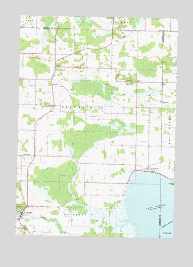
Poy Sippi, WI USGS Topographic Map
Click on map above to begin viewing in our Map Viewer.

This topographic map contains these locations and features:
Feature Name Type Latitude Longitude GNIS ID View Map
BrushvillePopulated PlaceN44.1700°W88.9959°1577528View Map
Christ Lutheran SchoolSchoolN44.2108°W88.9729°1563053View Map
Concordia CemeteryCemeteryN44.2202°W88.9696°1563312View Map
Concordia CemeteryCemeteryN44.2205°W88.9546°1563313View Map
Emmaus ChurchChurchN44.1414°W88.9907°1564637View Map
MetzPopulated PlaceN44.2136°W88.8865°1577727View Map
Poy SippiPopulated PlaceN44.1372°W88.9954°1571861View Map
Poy Sippi 1870C38 DamDamN44.1366°W88.9968°1792098View Map
Poy Sippi Census Designated PlaceCensusN44.1360°W88.9963°2585072View Map
Poy Sippi Elementary SchoolSchoolN44.1365°W88.9907°1845694View Map
Poy Sippi Millpond 131ReservoirN44.1366°W88.9968°1792099View Map
Poy Sippi Volunteer Fire DepartmentBuildingN44.1376°W88.9934°2697761View Map
Prellwitz CemeteryCemeteryN44.1897°W88.8848°1571912View Map
Saint John's Lutheran SchoolSchoolN44.2022°W88.8861°1573137View Map
Saint Johns CemeteryCemeteryN44.2136°W88.9076°1573048View Map
Saint Johns ChurchChurchN44.2022°W88.8862°1573093View Map
Town of BloomfieldCivilN44.1991°W88.9466°1582833View Map
TustinPopulated PlaceN44.1628°W88.8923°1575750View Map
Tustin Census Designated PlaceCensusN44.1696°W88.8963°2586564View Map
Tustin Volunteer Fire DepartmentBuildingN44.1636°W88.8926°2697969View Map
Waushara County Emergency Medical Services Poy Sippi DivisionBuildingN44.1376°W88.9934°2698262View Map
West BloomfieldPopulated PlaceN44.2208°W88.9718°1576454View Map
West Bloomfield Volunteer Fire DepartmentBuildingN44.2210°W88.9709°2698163View Map

Note: Coordinates in the location and feature list above are referenced to NAD83 datum.


Copyright (C) 2008-2024 Ryan Niemi / Sunset Dynamics ... All Rights Reserved