TopoQuest Logo
Do you find TopoQuest useful?
Help keep TopoQuest running and adding new maps/features by donating!
Bitcoin:  19c7KJd3qBynnjoSw5npx9KScwjBe4ifkT
Litecoin:  LXs6TkuXGGXo1vDsWCkWVdjQX94eUKd6ui
Home View Maps Find Maps Find Places Resources & Links


Big Bench, Utah Topographic Map

USGS Map Title: Big Bench, UT
USGS Map MRC: 37109D4
DRG (GeoTIFF) Download: o37109d4.tif


Neighboring USGS Topographic Map Quads:


  Black Mesa Butte, UT  
37109E5
 

  Blanding South, UT  
37109E4
 

  Bradford Canyon, UT  
37109E3
 

  No-Mans Island, UT  
37109D5
 

  Big Bench, UT  
37109D4
 

  McCracken Spring, UT  
37109D3
 

  Bluff, UT  
37109C5
 

  Recapture Pocket, UT  
37109C4
 

  Montezuma Creek, UT  
37109C3


Map MRC Location:

N38°
W110°
N38°
W109°
H8 H7 H6 H5 H4 H3 H2 H1
G8 G7 G6 G5 G4 G3 G2 G1
F8 F7 F6 F5 F4 F3 F2 F1
E8 E7 E6 E5 E4 E3 E2 E1
D8 D7 D6 D5 D4 D3 D2 D1
C8 C7 C6 C5 C4 C3 C2 C1
B8 B7 B6 B5 B4 B3 B2 B1
A8 A7 A6 A5 A4 A3 A2 A1
N37°
W110°
N37°
W109°

Big Bench, UT USGS 1:24K Topographic Map Preview:
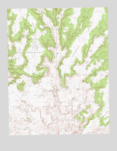
Big Bench, UT USGS Topographic Map
Click on map above to begin viewing in our Map Viewer.

This topographic map contains these locations and features:
Feature Name Type Latitude Longitude GNIS ID View Map
Big BenchBenchN37.4183°W109.4576°1425457View Map
Corral CanyonValleyN37.4972°W109.4590°1450311View Map
Corral CreekStreamN37.4964°W109.4590°1426881View Map
Cowboy PastureFlatN37.3858°W109.4740°1427022View Map
Fiddlers GreenBasinN37.4542°W109.4376°1427916View Map
Horse CanyonValleyN37.3789°W109.4387°1428831View Map
Horse Canyon ReservoirReservoirN37.4201°W109.4167°1435016View Map
Horse CreekStreamN37.3792°W109.4357°1435705View Map
Road CanyonValleyN37.4750°W109.4396°1431870View Map
Road Canyon PointCapeN37.4969°W109.4476°1431872View Map
Shumway PointRidgeN37.4717°W109.4104°1432430View Map
Trail of the AncientsTrailN37.4167°W109.4796°1455553View Map
Ute CanyonValleyN37.4583°W109.4298°1433845View Map
Ute PointCapeN37.4814°W109.4262°1433850View Map
White MesaPopulated PlaceN37.4658°W109.4676°1852450View Map
White Mesa Census Designated PlaceCensusN37.4596°W109.4600°2409583View Map

Note: Coordinates in the location and feature list above are referenced to NAD83 datum.


Copyright (C) 2008-2025 Ryan Niemi / Sunset Dynamics ... All Rights Reserved