TopoQuest Logo
Do you find TopoQuest useful?
Help keep TopoQuest running and adding new maps/features by donating!
Bitcoin:  19c7KJd3qBynnjoSw5npx9KScwjBe4ifkT
Litecoin:  LXs6TkuXGGXo1vDsWCkWVdjQX94eUKd6ui
Home View Maps Find Maps Find Places Resources & Links


Big Bend, California Topographic Map

USGS Map Title: Big Bend, CA
USGS Map MRC: 41121A8
DRG (GeoTIFF) Download: o41121a8.tif


Neighboring USGS Topographic Map Quads:


  Lake McCloud, CA  
41122B1
 

  Grizzly Peak, CA  
41121B8
 

  Dead Horse Summit, CA  
41121B7
 

  Shoeinhorse Mountain, CA  
41122A1
 

  Big Bend, CA  
41121A8
 

  Skunk Ridge, CA  
41121A7
 

  Goose Gap, CA  
40122H1
 

  Roaring Creek, CA  
40121H8
 

  Chalk Mountain, CA  
40121H7


Map MRC Location:

N42°
W122°
N42°
W121°
H8 H7 H6 H5 H4 H3 H2 H1
G8 G7 G6 G5 G4 G3 G2 G1
F8 F7 F6 F5 F4 F3 F2 F1
E8 E7 E6 E5 E4 E3 E2 E1
D8 D7 D6 D5 D4 D3 D2 D1
C8 C7 C6 C5 C4 C3 C2 C1
B8 B7 B6 B5 B4 B3 B2 B1
A8 A7 A6 A5 A4 A3 A2 A1
N41°
W122°
N41°
W121°

Big Bend, CA USGS 1:24K Topographic Map Preview:
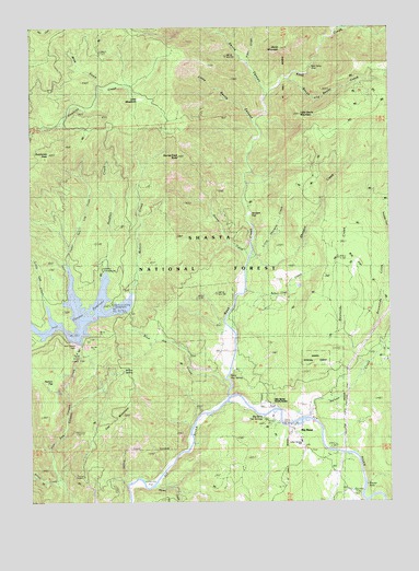
Big Bend, CA USGS Topographic Map
Click on map above to begin viewing in our Map Viewer.

This topographic map contains these locations and features:
Feature Name Type Latitude Longitude GNIS ID View Map
Alder CreekStreamN41.1152°W121.9261°266373View Map
Arvison FlatFlatN41.0757°W121.9253°256338View Map
Arvison Flat Guard Station (historical)LocaleN41.0749°W121.9247°1682358View Map
Baker CreekStreamN41.0554°W121.9269°256439View Map
Bear CampLocaleN41.1143°W121.9039°256626View Map
Big BendPopulated PlaceN41.0207°W121.9111°256886View Map
Big Bend Census Designated PlaceCensusN41.0108°W121.9240°2407839View Map
Big Bend Hot SpringsSpringN41.0227°W121.9202°253111View Map
Big Bend Hot SpringsLocaleN41.0243°W121.9253°277130View Map
Big Bend Post OfficePost OfficeN41.0197°W121.9118°2783790View Map
Big Bend RancheriaCivilN41.0264°W121.9189°256889View Map
Big Bend US Forest Service StationLocaleN41.0204°W121.9097°253110View Map
Big Bend Volunteer Fire Company 70BuildingN41.0150°W121.9062°2622087View Map
Big Cedar Camp (historical)LocaleN41.1235°W121.8817°1682360View Map
Big FlatFlatN41.0585°W121.8864°256925View Map
Blue Jay CreekStreamN41.0296°W121.9331°257246View Map
Camp PitLocaleN41.0029°W121.8914°257891View Map
Cedar Salt Log CreekStreamN41.0613°W121.9883°258147View Map
Cox RnachLocaleN41.0324°W121.8933°277126View Map
Deadlun CampgroundLocaleN41.0613°W121.9753°253128View Map
Deadlun CreekStreamN41.0604°W121.9747°259128View Map
Deer RanchLocaleN41.0238°W121.8928°277136View Map
Devils CanyonValleyN41.1099°W121.9211°259302View Map
Devils MountainSummitN41.1193°W121.9144°259323View Map
Dutchman PeakSummitN41.0915°W121.9944°259642View Map
East Fork Nelson CreekStreamN41.0399°W121.8792°259743View Map
Grasshopper FlatFlatN41.0402°W121.8864°251996View Map
Hawkins Landing CampgroundLocaleN41.0518°W121.9728°253137View Map
Hunt Hot SpringSpringN41.0335°W121.9317°261637View Map
Indian Springs Elementary SchoolSchoolN41.0160°W121.9081°261766View Map
Initial CreekStreamN41.0054°W121.9919°261789View Map
Iron Canyon 97-124 DamDamN41.0415°W121.9861°1663680View Map
Kinner FallsFallsN41.0046°W121.8847°262193View Map
Kinner RanchLocaleN41.0204°W121.8856°277127View Map
Kosk CreekStreamN41.0274°W121.9328°262239View Map
Kosk School (historical)SchoolN41.0377°W121.9114°1682382View Map
Lengel PlaceLocaleN41.0371°W121.8767°277124View Map
Little Devils CanyonValleyN41.1010°W121.9247°262586View Map
Little Devils MountainSummitN41.1018°W121.9075°262587View Map
Little Gap CreekStreamN41.0527°W121.9958°262603View Map
Little Joe FlatFlatN41.0040°W121.9606°262646View Map
Little MeadowsFlatN41.1060°W121.9631°262665View Map
Little Shotgun CreekStreamN41.0646°W121.9250°262725View Map
LoftonLocaleN41.0590°W121.9289°277121View Map
McGill CreekStreamN41.0549°W121.9658°263360View Map
Mica GulchValleyN41.1110°W121.9781°263487View Map
Nelson CreekStreamN41.0218°W121.9047°264046View Map
Nelson FlatFlatN41.0304°W121.9936°264048View Map
Nelson Flat TrailTrailN41.0374°W121.9733°264049View Map
Oak MountainSummitN41.0227°W121.9692°264291View Map
PowersLocaleN41.0535°W121.9150°277122View Map
RaynerLocaleN41.0415°W121.9344°277135View Map
Reynolds CreekStreamN41.0365°W121.8861°265383View Map
Rough and Ready CreekStreamN41.1113°W121.9122°265589View Map
Shotgun CreekStreamN41.0643°W121.9253°266141View Map
Smith FlatFlatN41.0527°W121.9661°266323View Map
Snowslide CreekStreamN41.0413°W121.8803°267340View Map
Stump CreekStreamN41.0649°W121.9250°267822View Map
Stump Creek ButteSummitN41.0910°W121.9500°267823View Map
Willow SpringSpringN41.0343°W121.9686°269190View Map
Winston BellLocaleN41.0432°W121.8900°277123View Map

Note: Coordinates in the location and feature list above are referenced to NAD83 datum.


Copyright (C) 2008-2025 Ryan Niemi / Sunset Dynamics ... All Rights Reserved