TopoQuest Logo
Do you find TopoQuest useful?
Help keep TopoQuest running and adding new maps/features by donating!
Bitcoin:  19c7KJd3qBynnjoSw5npx9KScwjBe4ifkT
Litecoin:  LXs6TkuXGGXo1vDsWCkWVdjQX94eUKd6ui
Home View Maps Find Maps Find Places Resources & Links


Presque Isle, Michigan Topographic Map

USGS Map Title: Presque Isle, MI
USGS Map MRC: 45083C4
DRG (GeoTIFF) Download: o45083c4.tif


Neighboring USGS Topographic Map Quads:


  Thompsons Harbor, MI  
45083C5
 

  Presque Isle, MI  
45083C4


  Long Lake West, MI  
45083B5
 

  Long Lake East, MI  
45083B4
 

  Middle Island, MI  
45083B3


Map MRC Location:

N46°
W84°
N46°
W83°
H8 H7 H6 H5 H4 H3 H2 H1
G8 G7 G6 G5 G4 G3 G2 G1
F8 F7 F6 F5 F4 F3 F2 F1
E8 E7 E6 E5 E4 E3 E2 E1
D8 D7 D6 D5 D4 D3 D2 D1
C8 C7 C6 C5 C4 C3 C2 C1
B8 B7 B6 B5 B4 B3 B2 B1
A8 A7 A6 A5 A4 A3 A2 A1
N45°
W84°
N45°
W83°

Presque Isle, MI USGS 1:24K Topographic Map Preview:
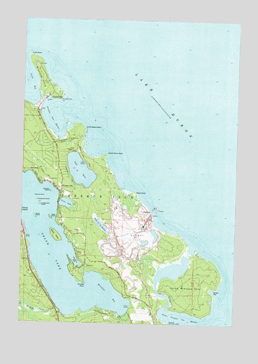
Presque Isle, MI USGS Topographic Map
Click on map above to begin viewing in our Map Viewer.

This topographic map contains these locations and features:
Feature Name Type Latitude Longitude GNIS ID View Map
Adeline Sims GraveCemeteryN45.3378°W83.4915°2374327View Map
Bell RiverStreamN45.2567°W83.4166°621040View Map
Brown IslandIslandN45.2861°W83.4800°622082View Map
Burnt IslandIslandN45.2936°W83.4919°622310View Map
Camp ChickagamiLocaleN45.3211°W83.4703°622548View Map
Cedar IslandIslandN45.2933°W83.4830°622915View Map
Crescent IslandIslandN45.3042°W83.4836°624045View Map
East Grand Lake Fire DepartmentBuildingN45.2939°W83.4758°2374277View Map
False Presque IsleIslandN45.2642°W83.3991°625819View Map
False Presque Isle HarborBarN45.2525°W83.4058°625820View Map
Grand Lake Branch LibraryBuildingN45.2933°W83.4758°2374276View Map
Grand Lake Community ChapelChurchN45.3039°W83.4761°2374275View Map
Harbor ViewPopulated PlaceN45.3428°W83.4869°627759View Map
Horseshoe IslandIslandN45.3006°W83.4911°628604View Map
Kauffman BayBayN45.2747°W83.4678°629474View Map
Knight BayBayN45.2636°W83.3875°629817View Map
Lake EsauLakeN45.3127°W83.4662°625639View Map
Lake of the WoodsLakeN45.2905°W83.4536°1616799View Map
Larks Harbor LodgeLocaleN45.3428°W83.4864°1618820View Map
Lotus LakeLakeN45.2992°W83.4740°631120View Map
Metzelaar BayBayN45.2620°W83.4505°632175View Map
North Albany PointCapeN45.3306°W83.4636°633468View Map
North PointCapeN45.3600°W83.4964°633627View Map
Old LighthouseLocaleN45.3420°W83.4780°634005View Map
Old Presque Isle LighthouseLocaleN45.3419°W83.4781°2374280View Map
Old Presque Isle Lighthouse Historical MarkerParkN45.3422°W83.4781°2374351View Map
Preque Isle LightLocaleN45.3567°W83.4922°1618819View Map
Presque IsleCapeN45.3514°W83.4889°635428View Map
Presque IslePopulated PlaceN45.3042°W83.4769°635430View Map
Presque Isle CemeteryCemeteryN45.3256°W83.4728°635431View Map
Presque Isle CorporationLocaleN45.2981°W83.4303°1618821View Map
Presque Isle HarborBayN45.3345°W83.4819°635432View Map
Presque Isle Harbor Census Designated PlaceCensusN45.3225°W83.4849°2583762View Map
Presque Isle Light Station Historical MarkerParkN45.3567°W83.4939°2374352View Map
Presque Isle LighthouseBuildingN45.3564°W83.4922°2374281View Map
Presque Isle Post OfficePost OfficeN45.3045°W83.4769°1625122View Map
Presque Isle Rear Range LighthouseBuildingN45.3378°W83.4903°2374279View Map
Presque Isle Township MuseumBuildingN45.3564°W83.4919°2374278View Map
Round IslandIslandN45.3025°W83.4925°636269View Map
South Albany PointCapeN45.3200°W83.4511°638257View Map
StoneportPopulated PlaceN45.2961°W83.4241°1617871View Map
Stoneport QuarryMineN45.2800°W83.4300°2726051View Map
Tanglewood IslandIslandN45.2983°W83.4897°1614581View Map
Township of Presque IsleCivilN45.2688°W83.4651°1626943View Map
Warren CreekStreamN45.2542°W83.4755°1615782View Map
Whiskey PointCapeN45.2664°W83.4625°1616286View Map
Wreck PointCapeN45.3039°W83.4336°1616828View Map

Note: Coordinates in the location and feature list above are referenced to NAD83 datum.


Copyright (C) 2008-2025 Ryan Niemi / Sunset Dynamics ... All Rights Reserved