TopoQuest Logo
Do you find TopoQuest useful?
Help keep TopoQuest running and adding new maps/features by donating!
Bitcoin:  19c7KJd3qBynnjoSw5npx9KScwjBe4ifkT
Litecoin:  LXs6TkuXGGXo1vDsWCkWVdjQX94eUKd6ui
Home View Maps Find Maps Find Places Resources & Links


Big Bend Dam, South Dakota Topographic Map

USGS Map Title: Big Bend Dam, SD
USGS Map MRC: 44099A4
DRG (GeoTIFF) Download: o44099a4.tif


Neighboring USGS Topographic Map Quads:


  Lower Brule NE, SD  
44099B5
 

  Stephan, SD  
44099B4
 

  Big Bend Dam NE, SD  
44099B3
 

  Lower Brule, SD  
44099A5
 

  Big Bend Dam, SD  
44099A4
 

  Big Bend Dam SE, SD  
44099A3
 

  Reliance, SD  
43099H5
 

  Short Creek, SD  
43099H4
 

  Bedashosha Lake, SD  
43099H3


Map MRC Location:

N45°
W100°
N45°
W99°
H8 H7 H6 H5 H4 H3 H2 H1
G8 G7 G6 G5 G4 G3 G2 G1
F8 F7 F6 F5 F4 F3 F2 F1
E8 E7 E6 E5 E4 E3 E2 E1
D8 D7 D6 D5 D4 D3 D2 D1
C8 C7 C6 C5 C4 C3 C2 C1
B8 B7 B6 B5 B4 B3 B2 B1
A8 A7 A6 A5 A4 A3 A2 A1
N44°
W100°
N44°
W99°

Big Bend Dam, SD USGS 1:24K Topographic Map Preview:
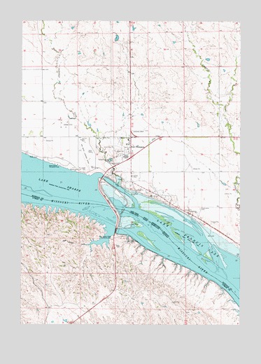
Big Bend Dam, SD USGS Topographic Map
Click on map above to begin viewing in our Map Viewer.

This topographic map contains these locations and features:
Feature Name Type Latitude Longitude GNIS ID View Map
Big Bend DamDamN44.0517°W99.4523°1253908View Map
Big Bend Landing Strip (historical)AirportN44.0700°W99.4646°1260072View Map
Christ Episcopal CemeteryCemeteryN44.0579°W99.4425°2773586View Map
Crow Creek Fire DepartmentBuildingN44.0738°W99.4403°2580666View Map
Crow Creek Police DepartmentBuildingN44.0742°W99.4407°2755453View Map
Crow Creek Sioux Ambulance ServiceBuildingN44.0731°W99.4394°2658958View Map
Fort ThompsonPopulated PlaceN44.0686°W99.4379°1255117View Map
Fort Thompson Census Designated PlaceCensusN44.0527°W99.4079°2393006View Map
Fort Thompson Post OfficePost OfficeN44.0685°W99.4370°2709887View Map
Fort Thompson Recreation AreaParkN44.0611°W99.4473°1263567View Map
Good Soldier CreekStreamN44.0383°W99.4493°1255278View Map
Good Soldier Creek Recreation AreaParkN44.0358°W99.4487°1255279View Map
Lake View CemeteryCemeteryN44.0630°W99.4641°2773585View Map
North Shore Recreation AreaParkN44.0675°W99.4793°1256777View Map
Presbyterian CemeteryCemeteryN44.0477°W99.3981°2773587View Map
Saint Joseph CemeteryCemeteryN44.0633°W99.4649°1257636View Map
Soldier CreekStreamN44.0578°W99.4459°1265377View Map
Tailwaters Recreation AreaParkN44.0344°W99.4398°1258497View Map
Trailwaters Recreation AreaParkN44.0347°W99.4365°1265481View Map

Note: Coordinates in the location and feature list above are referenced to NAD83 datum.


Copyright (C) 2008-2024 Ryan Niemi / Sunset Dynamics ... All Rights Reserved