TopoQuest Logo
Do you find TopoQuest useful?
Help keep TopoQuest running and adding new maps/features by donating!
Bitcoin:  19c7KJd3qBynnjoSw5npx9KScwjBe4ifkT
Litecoin:  LXs6TkuXGGXo1vDsWCkWVdjQX94eUKd6ui
Home View Maps Find Maps Find Places Resources & Links


Pueblo Bonito, New Mexico Topographic Map

USGS Map Title: Pueblo Bonito, NM
USGS Map MRC: 36107A8
DRG (GeoTIFF) Download: o36107a8.tif


Neighboring USGS Topographic Map Quads:


  Pretty Rock, NM  
36108B1
 

  Pueblo Bonito NW, NM  
36107B8
 

  Kimbeto, NM  
36107B7
 

  Kin Klizhin Ruins, NM  
36108A1
 

  Pueblo Bonito, NM  
36107A8
 

  Sargent Ranch, NM  
36107A7
 

  Nose Rock, NM  
35108H1
 

  Seven Lakes NW, NM  
35107H8
 

  Seven Lakes NE, NM  
35107H7


Map MRC Location:

N37°
W108°
N37°
W107°
H8 H7 H6 H5 H4 H3 H2 H1
G8 G7 G6 G5 G4 G3 G2 G1
F8 F7 F6 F5 F4 F3 F2 F1
E8 E7 E6 E5 E4 E3 E2 E1
D8 D7 D6 D5 D4 D3 D2 D1
C8 C7 C6 C5 C4 C3 C2 C1
B8 B7 B6 B5 B4 B3 B2 B1
A8 A7 A6 A5 A4 A3 A2 A1
N36°
W108°
N36°
W107°

Pueblo Bonito, NM USGS 1:24K Topographic Map Preview:
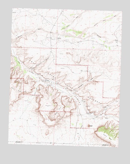
Pueblo Bonito, NM USGS Topographic Map
Click on map above to begin viewing in our Map Viewer.

This topographic map contains these locations and features:
Feature Name Type Latitude Longitude GNIS ID View Map
15R-307 Water WellWellN36.1206°W107.9998°923431View Map
Alto ChjiquitoBuildingN36.0697°W107.9576°939262View Map
Alto GrandeBuildingN36.0697°W107.9576°939261View Map
Betonnie Tsosie WashStreamN36.0997°W107.9237°897311View Map
C C Field Water WellWellN36.0311°W107.9045°923422View Map
Casa Chiquita (historical)LocaleN36.0695°W107.9759°898269View Map
Casa Rinconada (historical)LocaleN36.0539°W107.9581°902199View Map
CC Kernodle Number 1 Water WellWellN36.0313°W107.9045°923421View Map
Chaco CanyonValleyN36.0603°W107.9670°887400View Map
Chaco Canyon Trading PostLocaleN36.0989°W107.9481°901249View Map
Chaco Canyon Weather StationLocaleN36.0583°W107.9590°932439View Map
Chaco Culture National Historical ParkParkN36.0397°W107.9559°936878View Map
Chaco Post Office (historical)Post OfficeN36.0606°W107.9617°938535View Map
Chacra MesaSummitN36.0089°W107.8914°901274View Map
Chettro KettleLocaleN36.0606°W107.9542°898285View Map
Clys CanyonValleyN36.0672°W107.9776°887698View Map
Fajada ButteSummitN36.0189°W107.9098°902244View Map
Fajada WashStreamN36.0256°W107.9178°897364View Map
Gallo CampgroundLocaleN36.0364°W107.8906°889306View Map
Gallo WashStreamN36.0439°W107.9248°889309View Map
Heshoda BitsulliyaLocaleN36.0583°W107.9670°902107View Map
Hungo Pavie (historical)LocaleN36.0500°W107.9301°898339View Map
Kimbeto WashStreamN36.1014°W107.9448°902279View Map
Kin Kletso (historical)LocaleN36.0650°W107.9703°898347View Map
Kin Nahasbasd (historical)LocaleN36.0370°W107.9137°898349View Map
Mockingbird CanyonValleyN36.0464°W107.9265°892134View Map
Pueblo Alto (historical)LocaleN36.0697°W107.9576°898408View Map
Pueblo BonitoLocaleN36.0606°W107.9617°938826View Map
Pueblo Bonito Ranger StationLocaleN36.0597°W107.9609°893511View Map
Pueblo del Arroyo (historical)LocaleN36.0611°W107.9659°902331View Map
PutnamLocaleN36.0606°W107.9617°901400View Map
Putnam Post Office (historical)Post OfficeN36.0606°W107.9617°937679View Map
Sheep Camp CanyonValleyN36.0072°W107.8756°894769View Map
South GapGapN36.0503°W107.9715°895061View Map
South MesaSummitN36.0195°W107.9501°899921View Map
Tsin Kletzin (historical)LocaleN36.0364°W107.9578°898458View Map
Una Vida (historical)LocaleN36.0333°W107.9123°898460View Map
Weritos RinconValleyN36.0533°W107.9426°896321View Map
West MesaSummitN36.0408°W107.9970°896391View Map
Willeto WellWellN36.0965°W107.8802°896621View Map
Yazzi WellWellN36.1075°W107.9401°896807View Map

Note: Coordinates in the location and feature list above are referenced to NAD83 datum.


Copyright (C) 2008-2024 Ryan Niemi / Sunset Dynamics ... All Rights Reserved