TopoQuest Logo
Do you find TopoQuest useful?
Help keep TopoQuest running and adding new maps/features by donating!
Bitcoin:  19c7KJd3qBynnjoSw5npx9KScwjBe4ifkT
Litecoin:  LXs6TkuXGGXo1vDsWCkWVdjQX94eUKd6ui
Home View Maps Find Maps Find Places Resources & Links


Pulaski, Wisconsin Topographic Map

USGS Map Title: Pulaski, WI
USGS Map MRC: 44088F2
DRG (GeoTIFF) Download: o44088f2.tif


Neighboring USGS Topographic Map Quads:


  Krakow, WI  
44088G3
 

  Oconto Falls South, WI  
44088G2
 

  Abrams, WI  
44088G1
 

  Zachow, WI  
44088F3
 

  Pulaski, WI  
44088F2
 

  Suamico, WI  
44088F1
 

  Seymour, WI  
44088E3
 

  Oneida North, WI  
44088E2
 

  Green Bay West, WI  
44088E1


Map MRC Location:

N45°
W89°
N45°
W88°
H8 H7 H6 H5 H4 H3 H2 H1
G8 G7 G6 G5 G4 G3 G2 G1
F8 F7 F6 F5 F4 F3 F2 F1
E8 E7 E6 E5 E4 E3 E2 E1
D8 D7 D6 D5 D4 D3 D2 D1
C8 C7 C6 C5 C4 C3 C2 C1
B8 B7 B6 B5 B4 B3 B2 B1
A8 A7 A6 A5 A4 A3 A2 A1
N44°
W89°
N44°
W88°

Pulaski, WI USGS 1:24K Topographic Map Preview:
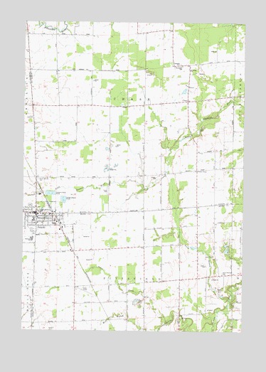
Pulaski, WI USGS Topographic Map
Click on map above to begin viewing in our Map Viewer.

This topographic map contains these locations and features:
Feature Name Type Latitude Longitude GNIS ID View Map
Assumption of the Blessed Virgin Mary Elementary SchoolSchoolN44.6733°W88.2418°1838203View Map
Brown County Library Pulaski Branch LibraryBuildingN44.6722°W88.2456°2709150View Map
Camelot TerracePopulated PlaceN44.6594°W88.2189°2631379View Map
Carter AirportAirportN44.6421°W88.2132°1582166View Map
ChasePopulated PlaceN44.7180°W88.1568°1562960View Map
Chase CemeteryCemeteryN44.7328°W88.1615°1843948View Map
Chase QuarryMineN44.7272°W88.2092°2709837View Map
Franciscan MonasteryChurchN44.6733°W88.2412°1565249View Map
Glenbrook Elementary SchoolSchoolN44.6699°W88.2440°1565566View Map
Good Cheer School (historical)SchoolN44.6875°W88.2018°1843967View Map
New Paramedic RescueBuildingN44.6728°W88.2460°2698446View Map
North Branch Suamico RiverStreamN44.6380°W88.1323°1570395View Map
North Pittsfield CemeteryCemeteryN44.6483°W88.1365°1570481View Map
North Pittsfield School (historical)SchoolN44.6567°W88.1604°1838155View Map
Pittsfield Church (historical)ChurchN44.6480°W88.1368°1838163View Map
Pleasant View Mobile Home ParkPopulated PlaceN44.6819°W88.2022°2631388View Map
Polish National CemeteryCemeteryN44.6862°W88.2416°1571739View Map
Potter CreekStreamN44.6278°W88.1673°1571843View Map
PulaskiPopulated PlaceN44.6722°W88.2426°1581840View Map
Pulaski Community Middle SchoolSchoolN44.6620°W88.2445°2716707View Map
Pulaski High SchoolSchoolN44.6589°W88.2401°1838165View Map
Pulaski Police DepartmentBuildingN44.6686°W88.2429°2759493View Map
Pulaski Tri - County Fire DepartmentBuildingN44.6638°W88.2276°2697950View Map
Saint Joseph CemeteryCemeteryN44.7322°W88.1598°1573153View Map
Saint Joseph ChurchChurchN44.7305°W88.1554°1573163View Map
South ChasePopulated PlaceN44.6900°W88.1512°1577830View Map
Sunnyside Elementary SchoolSchoolN44.6983°W88.1504°2713184View Map
Sunnyside School (historical)SchoolN44.7164°W88.2195°1844026View Map
Town of ChaseCivilN44.7209°W88.1886°1582946View Map
Town of PittsfieldCivilN44.6289°W88.1855°1583928View Map
Village of PulaskiCivilN44.6685°W88.2354°1583988View Map
WQLH-FM (Green Bay)TowerN44.6447°W88.1370°1582599View Map
Zion Church (historical)ChurchN44.7172°W88.1757°1844037View Map

Note: Coordinates in the location and feature list above are referenced to NAD83 datum.


Copyright (C) 2008-2025 Ryan Niemi / Sunset Dynamics ... All Rights Reserved