TopoQuest Logo
Do you find TopoQuest useful?
Help keep TopoQuest running and adding new maps/features by donating!
Bitcoin:  19c7KJd3qBynnjoSw5npx9KScwjBe4ifkT
Litecoin:  LXs6TkuXGGXo1vDsWCkWVdjQX94eUKd6ui
Home View Maps Find Maps Find Places Resources & Links


Big Cedar, Oklahoma Topographic Map

USGS Map Title: Big Cedar, OK
USGS Map MRC: 34094F6
DRG (GeoTIFF) Download: o34094f6.tif


Neighboring USGS Topographic Map Quads:


  Leflore SE, OK  
34094G7
 

  Hodgen, OK  
34094G6
 

  Hontubby, OK  
34094G5
 

  Muse, OK  
34094F7
 

  Big Cedar, OK  
34094F6
 

  Page, OK  
34094F5
 

  Ludlow, OK  
34094E7
 

  Octavia, OK  
34094E6
 

  Lynn Mountain, OK  
34094E5


Map MRC Location:

N35°
W95°
N35°
W94°
H8 H7 H6 H5 H4 H3 H2 H1
G8 G7 G6 G5 G4 G3 G2 G1
F8 F7 F6 F5 F4 F3 F2 F1
E8 E7 E6 E5 E4 E3 E2 E1
D8 D7 D6 D5 D4 D3 D2 D1
C8 C7 C6 C5 C4 C3 C2 C1
B8 B7 B6 B5 B4 B3 B2 B1
A8 A7 A6 A5 A4 A3 A2 A1
N34°
W95°
N34°
W94°

Big Cedar, OK USGS 1:24K Topographic Map Preview:
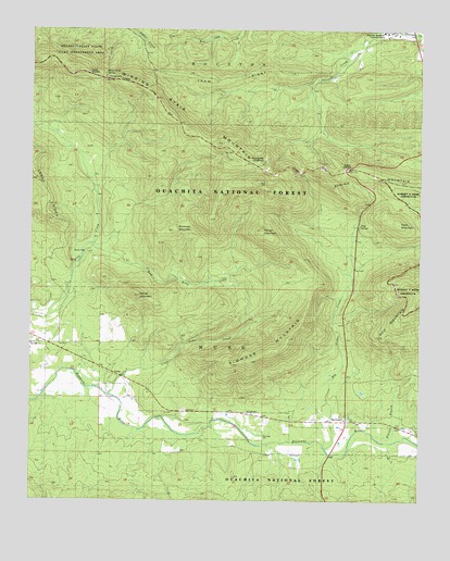
Big Cedar, OK USGS Topographic Map
Click on map above to begin viewing in our Map Viewer.

This topographic map contains these locations and features:
Feature Name Type Latitude Longitude GNIS ID View Map
Big CedarPopulated PlaceN34.6459°W94.6488°1101279View Map
Big Cedar CemeteryCemeteryN34.6459°W94.6458°2711772View Map
Big Cedar CreekStreamN34.6401°W94.6558°1101280View Map
Big Cedar Volunteer Fire Department Station 1 HeadquartersBuildingN34.6460°W94.6553°2657158View Map
Big Cedar Work CenterLocaleN34.6487°W94.7008°1100969View Map
Billy Creek CampgroundLocaleN34.6898°W94.7330°1100967View Map
Billy Creek TrailTrailN34.7137°W94.7044°1100966View Map
Bowman MountainSummitN34.6970°W94.7047°1101305View Map
Carver MountainSummitN34.6795°W94.7161°1101333View Map
Coon MountainSummitN34.6990°W94.6319°1101366View Map
County District 3CivilN34.6515°W94.7017°2418890View Map
East Billy CreekStreamN34.6912°W94.7327°1101406View Map
Elkins BranchStreamN34.6682°W94.6288°1738112View Map
Emerald Vista Recreation SiteLocaleN34.7165°W94.6747°1102136View Map
Horse Thief Spring CampgroundLocaleN34.7376°W94.7266°1763663View Map
Horse Thief SpringsSpringN34.7381°W94.7273°1100971View Map
Jim E Hamilton Correctional CenterBuildingN34.7493°W94.6361°1100972View Map
John F Kennedy MemorialLocaleN34.6457°W94.6533°1100970View Map
Little Cedar CreekStreamN34.6534°W94.7252°1101510View Map
Pipe SpringSpringN34.6979°W94.6447°1101592View Map
Pipe Springs CampgroundLocaleN34.6959°W94.6463°1100968View Map
Robert S Kerr ArboretumParkN34.6940°W94.6316°1747118View Map
Rough MountainSummitN34.6968°W94.6755°1101639View Map
Sallisaw Creek Site 17 DamDamN34.7418°W94.7269°1757927View Map
Sallisaw Creek Site 17 ReservoirReservoirN34.7418°W94.7269°1757928View Map
Simmons MountainSummitN34.6620°W94.6786°1101662View Map
Spring MountainSummitN34.7095°W94.6294°1101672View Map
Township of MuseCivilN34.6584°W94.6919°1824685View Map
Tram RidgeRidgeN34.7376°W94.6763°1101699View Map
Two Mile ChurchChurchN34.6665°W94.7499°1738111View Map
United States Forest Service Big Cedar Work CenterBuildingN34.6489°W94.7005°2657228View Map
Winding Stair MountainRidgeN34.7093°W94.6774°1101742View Map
Winding Star CampgroundLocaleN34.7148°W94.6758°1100965View Map

Note: Coordinates in the location and feature list above are referenced to NAD83 datum.


Copyright (C) 2008-2025 Ryan Niemi / Sunset Dynamics ... All Rights Reserved