TopoQuest Logo
Do you find TopoQuest useful?
Help keep TopoQuest running and adding new maps/features by donating!
Bitcoin:  19c7KJd3qBynnjoSw5npx9KScwjBe4ifkT
Litecoin:  LXs6TkuXGGXo1vDsWCkWVdjQX94eUKd6ui
Home View Maps Find Maps Find Places Resources & Links


Queets, Washington Topographic Map

USGS Map Title: Queets, WA
USGS Map MRC: 47124E3
DRG (GeoTIFF) Download: o47124e3.tif


Neighboring USGS Topographic Map Quads:


  Destruction Island, WA  
47124F4
 

  Kalaloch Ridge, WA  
47124F3
 

  Christmas Creek, WA  
47124F2


  Queets, WA  
47124E3
 

  Salmon River West, WA  
47124E2


  Tunnel Island, WA  
47124D3
 

  O'Took Prairie, WA  
47124D2


Map MRC Location:

N48°
W125°
N48°
W124°
H8 H7 H6 H5 H4 H3 H2 H1
G8 G7 G6 G5 G4 G3 G2 G1
F8 F7 F6 F5 F4 F3 F2 F1
E8 E7 E6 E5 E4 E3 E2 E1
D8 D7 D6 D5 D4 D3 D2 D1
C8 C7 C6 C5 C4 C3 C2 C1
B8 B7 B6 B5 B4 B3 B2 B1
A8 A7 A6 A5 A4 A3 A2 A1
N47°
W125°
N47°
W124°

Queets, WA USGS 1:24K Topographic Map Preview:
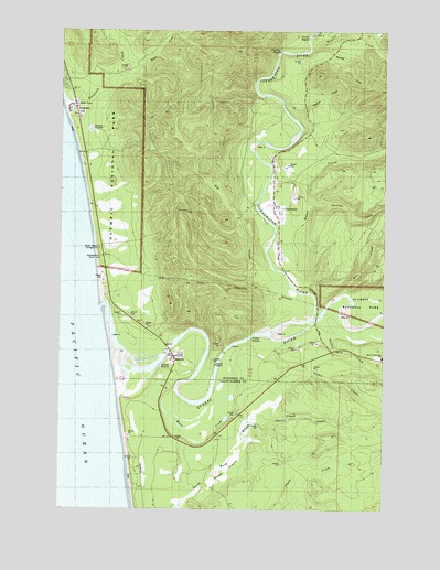
Queets, WA USGS Topographic Map
Click on map above to begin viewing in our Map Viewer.

This topographic map contains these locations and features:
Feature Name Type Latitude Longitude GNIS ID View Map
Ashenbrenner Picnic AreaLocaleN47.5642°W124.3605°1529091View Map
Beach Trail 1TrailN47.5779°W124.3644°1516206View Map
Beach Trail 2TrailN47.5909°W124.3682°1516207View Map
Boulder CreekStreamN47.5784°W124.2807°1516837View Map
ClearwaterPopulated PlaceN47.5776°W124.2946°1517842View Map
Clearwater RiverStreamN47.5462°W124.2919°1517847View Map
Clearwater State ParkParkN47.5742°W124.2910°1529570View Map
East Fork Kalaloch CreekStreamN47.6145°W124.3480°1519104View Map
Elk CreekStreamN47.5473°W124.2966°1519268View Map
Elk Creek LookoutLocaleN47.5498°W124.3091°1519278View Map
Fisher CreekStreamN47.5429°W124.3038°1519602View Map
Fisher RapidsRapidsN47.5442°W124.3027°1519611View Map
Harlow CreekStreamN47.5484°W124.2763°1520550View Map
Hunt CreekStreamN47.6201°W124.2802°1521077View Map
Hurst CreekStreamN47.5726°W124.2932°1521097View Map
Jefferson County Sheriff's Office Forks SubstationBuildingN47.5780°W124.2940°2722027View Map
KalalochPopulated PlaceN47.6045°W124.3724°1521546View Map
Kerr CreekStreamN47.5554°W124.2680°1521629View Map
Moses CreekStreamN47.5326°W124.3291°1523385View Map
Moses PrairieFlatN47.5090°W124.3113°1523389View Map
Parson RapidsRapidsN47.6234°W124.2794°1524225View Map
Preacher RapidsRapidsN47.6187°W124.2927°1524628View Map
QueetsPopulated PlaceN47.5395°W124.3324°1524759View Map
Queets - Clearwater Elementary SchoolSchoolN47.5398°W124.2516°1531080View Map
Queets Census Designated PlaceCensusN47.5315°W124.3384°2585025View Map
Queets RiverStreamN47.5445°W124.3560°1531493View Map
South Beach CampgroundLocaleN47.5679°W124.3613°1529065View Map
Waring CreekStreamN47.6201°W124.2771°1527807View Map
Wildcat CreekStreamN47.6009°W124.2860°1528132View Map

Note: Coordinates in the location and feature list above are referenced to NAD83 datum.


Copyright (C) 2008-2025 Ryan Niemi / Sunset Dynamics ... All Rights Reserved